Counter-UAS anti-drone detection systems
A drone flies over your site. Do you know?
DroneBase C-UAS drone detection systems pick up a drone from up to 10 km away and show, in real time, its model, serial number, altitude, flight path and — in most cases — the position of the person flying it. Fully passive drone radar detection: it receives, it never transmits. Designed for industrial plants, critical infrastructure, military sites, events and private estates.
Maximum values refer to the configurations in the DroneBase catalogue. Real-world performance varies with the model chosen, the radio environment, the layout of the site and the type of drone detected.
In a few years the drone has gone from rare object to everyday presence
It costs a few hundred euros, is sold everywhere, flies twenty minutes out of the box and carries a camera that reads a number plate from two hundred metres. That has changed the way a site is looked at from above — and the way it is observed without permission.
The incidents that brought the subject to the front pages — overflights of airports, industrial plants, military installations and residences — have moved drone detection from niche technology to a recurring item in security plans, alongside video surveillance and access control.
The point is that none of the traditional security systems look up. Fences, cameras, perimeter sensors and guards are designed for ground level. Above three metres, on most sites, there is nothing.
What is a C-UAS drone detection system
A drone detection system (passive counter-UAS) is a receiving device that intercepts and decodes the radio traffic between a drone and its remote controller. From that traffic it derives the model, serial number, position, altitude, speed and flight path of the aircraft and, on most models, the position of the pilot. It transmits no signal and does not interfere with the drone: it detects, identifies and documents. DroneBase offers it in fixed, transportable and handheld configurations.
What a drone nobody saw coming can do
It is not only about footage. An undetected overflight is a matter of security, of industrial confidentiality and — in some contexts — of personal safety. That is why counter-UAS has entered security plans alongside video surveillance and access control.

Unauthorised observation
Plant layout, goods handling, staff shifts, gate positions, storage areas. Information that is protected on the ground and in plain sight from above, captured in minutes and without leaving a trace.

Carrying and dropping objects
A commercial drone carries enough payload to clear any fence. That is why the issue has become central in prisons, military sites and facilities handling sensitive materials.

No evidence, no follow-up
Without detection, a report is just a witness's word. With detection you keep the serial number, time, flight path and pilot position: concrete elements to hand over to the relevant authorities.
It does not look for the drone in the sky.
It listens to its radio.
Every commercial drone is in constant dialogue with its remote controller. That dialogue travels on known frequencies and carries, in the clear or in decodable form, the identity of the aircraft and its flight parameters.
DroneBase systems receive and decode that traffic. No clear line of sight is needed as with a camera, no good weather, no daylight: they work at night, in fog, behind a building.
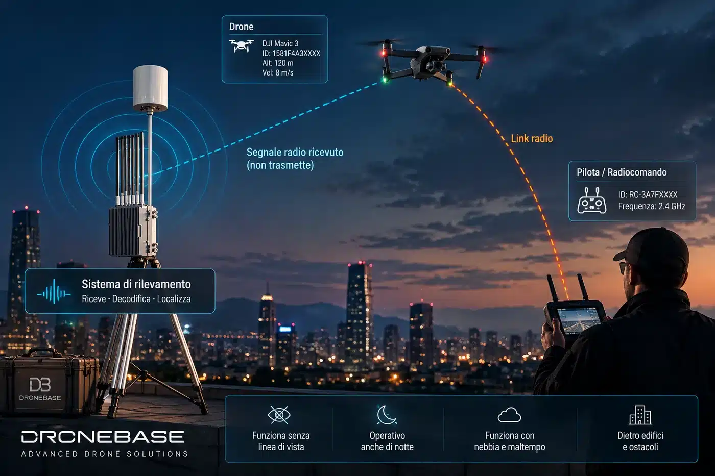
The system receives the radio traffic exchanged between drone and remote controller: from that stream it extracts the identifier, model, altitude and speed of the aircraft and derives the position of whoever is flying it. No signal is transmitted towards the drone.
Passive means it transmits nothing
The system only receives. It emits no signal, does not interfere with the drone and does not disturb nearby communications. That is the substantial difference from jamming equipment, which transmits and is subject to an entirely different set of rules.
Not a generic alarm: an identity with a name and a position
The difference between knowing that «something is flying» and knowing which drone it is, where it came from and where the person controlling it is.

Example of the operating screen: the protected site in the centre, the coverage rings, the flight path of the detected drone and the detail card with serial number, altitude, speed, heading and estimated pilot position. Bottom left, the system status is always visible: passive, receiving, not transmitting.
Serial number and model
Unique identifier of the aircraft and Remote ID fingerprint, useful for documenting recurring incidents.
Position and altitude
Latitude, longitude, altitude and speed in real time, with accuracy down to 3 m on decodable drones.
Pilot position
On most models the system also locates the remote controller: drone and operator on the same map.
Flight path
Full route plotted on the map, up to 11 simultaneous tracks in distinct colours.
Whitelists and blacklists
Authorised drones raise no alarm; unwanted ones are flagged by serial number, automatically if required.
Event history
Configurable archive of up to 365 days of detections and flight paths, with statistics by period.
From the fixed installation to the device that fits in one hand
The choice depends on what you protect: an unchanging perimeter calls for a fixed system, an operation that moves calls for a portable tool. All configurations are passive and work offline, with no internet connection.

Drone Detection Radar Stationary
Permanent coverage for a site that needs protecting every day. Installed once, it stays on 24/7 and integrates with existing security systems through APIs.
- 360° coverage · continuous 24/7 monitoring
- 99% of DJI models, plus Autel, Parrot, Hubsan and Wi-Fi
- Built-in local server: no internet connection required
- Customisable APIs for integration with existing C2 systems
- Weather-resistant housing for permanent outdoor use

Drone Detection Radar Stationary Pro
The most complete configuration: besides drones it receives aircraft transponders and ship signals, and integrates a proximity radar with acoustic and light deterrence. One unit covers the air, maritime and perimeter picture.
- 360° coverage · response in under 1 second
- Receives drones, aircraft and ships (2.4 / 5.8 GHz · 1.09 GHz · 162 MHz)
- 10 m proximity radar with flashing lights and loudspeaker
- Remotely tiltable antenna via internal servo mechanism
- IP66 · 5 kg · −30 / +55 °C · 220 V mains, PoE, power bank or solar

Drone Detection Radar Mobile
The longest range in the line-up, in a 14 kg case. Carry it where it is needed, switch it on, and within two seconds it has already identified what is flying within ten kilometres.
- Universal frequency coverage, 25–6000 MHz
- Success rate >99% · detection in ≤ 2 seconds
- 10-hour battery life, up to 24 h with an external power bank
- Internal server and multi-touch monitor, offline operation
- Real-time GPS tracking of drone and pilot

Drone Detection Radar Mobile — H3 Pro
Fits in a pocket and weighs under 600 grams. CRPC 2.0 technology with Remote ID monitoring: switch it on and it goes straight into detection mode, no set-up required.
- Detects up to 98% of civilian drones · response ≤ 5 s
- Up to 12 drones detected and 11 simultaneous tracks
- 6" Android display, Italian-language interface, offline maps
- 12,000 mAh battery · 3–4 h · IP54 · −20 / +50 °C
- Usable on the move from a vehicle at up to 60 km/h
The configurations are complementary: a large site is often protected with a fixed unit on the perimeter and a handheld unit issued to the security team. Fixed units can be networked to cover very large areas from a single control station.
Not sure which configuration your site needs? We define it together, no obligation.
One station for the air, maritime and perimeter picture
The high-end fixed configurations do not stop at drones. They also receive aircraft transponders and ship identification signals, and watch the ground immediately around the unit. That is why a single installation replaces several separate devices.
Aircraft via ADS-B
Reception of civil aviation transponders with a theoretical range of up to 200 km: useful where manned traffic and drones share the same airspace.
Ships via AIS
Reception of ship identification signals with a theoretical range of up to 100 km, for ports, coastal areas and maritime infrastructure.
Proximity radar
Detection of people or animals within 10 metres of the unit, with red-blue flashing lights and a high-power loudspeaker for immediate deterrence.
Remotely tiltable antenna
Internal servo mechanism: the tilt is adjusted from the platform, to compensate for low-level installations and reduce blind cones.
Networking of multiple units
Several units connected to the same platform cover very large areas and can trigger the automatic dispatch of a drone from the nearest dock to document the event.
Four power options
220 V mains, PoE, 12 V power bank or solar panel, freely switchable: the unit stays operational even where there is no mains supply.
Flexible installation
Tripod, fixed pole, magnetic mount or vehicle mounting. IP66 protection rating and operating range from −30 to +55 °C.
Management platform
Real-time alarms, operating parameters, track playback and report generation, from a browser or a mobile app.
Drone radar detection: which system for which need
Data as declared in the respective datasheets. Correct sizing depends on the extent of the area, the continuity required, the sources to be monitored and whether staff are present on site.
| Feature | Stationary Pro | Stationary | Mobile | H3 Pro |
|---|---|---|---|---|
| Detection range | up to 8 km | 5–8 km | up to 10 km | up to 3 km |
| Deployment | Fixed, vehicle-mounted or on tripod | Permanent fixed installation | Transportable in a case, 14 kg | Handheld, 580 g |
| Sources received | Drones, ADS-B aircraft, AIS ships | Multi-brand drones and Wi-Fi | Drones, 25–6000 MHz | Drones, 900 MHz · 1.4 · 2.4 · 5.8 GHz · Wi-Fi |
| Response time | under 1 second | Real time | ≤ 2 seconds | ≤ 5 seconds |
| Power supply | 220 V, PoE, 12 V power bank or solar | Mains, 24/7 operation | 10 h battery (24 h with power bank) | 12,000 mAh battery, 3–4 h |
| Pilot location | Yes | Yes | Yes, on most models | Yes, accuracy ≤ 3 m |
| Proximity alarm | 10 m radar with flashing lights and loudspeaker | — | — | — |
| Protection and temperatures | IP66 · −30 / +55 °C | Housing for permanent outdoor use | Rugged transport case | IP54 · −20 / +50 °C |
| Offline operation | Yes | Yes, built-in local server | Yes, internal server | Yes, offline maps and database |
| Best suited to | Large sites, ports, areas with air traffic | Industrial plants, barracks, sensitive sites | Events, missions, temporary deployments | Patrols, site surveys, personal use |
Where drone detection is already part of the security plan
Different contexts, the same basic need: knowing what is flying over the site, when, and who is controlling it.
Industrial plants
Protection against unauthorised observation of production lines, layouts and goods handling.
Barracks and military sites
Outposts, bases and restricted areas. Continuous operation and resistance to harsh conditions.
Critical infrastructure
Power stations, refineries, chemical plants, depots and strategic energy hubs.
Events and public gatherings
Concerts, stadiums, trade fairs and rallies: temporary coverage with rapid deployment and multi-unit networking.
Prisons and correctional facilities
Prevention of contraband drops and pilot location for rapid intervention.
Airports and airfields
Airspace protection and prevention of interference with approaching traffic.
Residences and private estates
Airspace control over villas, estates and the homes of high-profile individuals, with data stored locally.
Law enforcement and security
Mobile patrols, escorts, control of sensitive perimeters and support for operations in the field.
A home has airspace above it too
This is not only about barracks and factories. A villa, an isolated property, a fenced garden, the residence of a high-profile person: these are contexts where an overflight with a camera is a matter of personal privacy before it is a matter of security.
Since these are purely receiving devices, detection interferes with nothing and needs no infrastructure: the handheld model switches on and works, the fixed model is installed like any other security control unit.
And the data stays where it is collected: the systems work offline, with local storage and no need for an internet connection or external platforms.
Detecting is not intervening
These systems detect and identify: they do not jam, capture or bring down drones. Active countermeasures that act on the drone are governed by different rules and are reserved for authorised bodies. In the event of a suspicious overflight, the correct use of the data collected is a report to the competent authorities.
No emissions
Receiving devices: they do not transmit and do not interfere with other equipment.
Local data
On-board storage, no mandatory cloud and no internet connection.
Always on
The fixed model works 24/7; the handheld units switch on straight into detection mode.
Whitelist
Authorised drones — your own or your suppliers' — raise no alarm.
Documentation
Serial number, time and flight path: concrete elements for a report.
No infrastructure
The handheld unit needs no installation work: switch it on and it works, on the move too.
Those who sell drones know how drones behave
Sizing a detection system means understanding where a drone would come from, at what altitude, with which aircraft and with what radio range. It is the same trade, seen from the other side.
Site analysis
Extent of the area, plausible take-off points, obstacles and radio environment: this is where the choice between fixed, mobile and handheld starts.
Installation and configuration
Positioning, calibration, definition of thresholds and lists, integration with the security systems already in use through APIs.
Operator training
Reading detections, managing lists, telling legitimate traffic from anomalies, reporting procedures.
Database updates
New models arrive all the time: updates keep recognition aligned, offline too.
Technical support
Dedicated consultant, pre- and after-sales support and on-site demos to evaluate the system in the real environment.
Incentives and MEPA
Iper Ammortamento and Nuova Sabatini (Italy) for businesses, operating lease over 24–60 months, MEPA procurement for Italian public administration.
What we are asked most often
Is this an anti-drone system?
Yes, for the detection part. An anti-drone (C-UAS, counter-UAS) system has two functions: detecting the drone and, for authorised bodies only, countering it. DroneBase systems cover the first: they detect, identify and track drone and pilot in real time, without emitting any signal.
Does the system jam or bring down the drone?
No, and the distinction matters. These devices are purely receivers: they detect, identify and track without transmitting anything towards the drone. Active countermeasures are governed by different rules and are reserved for authorised bodies.
Do I need a permit to install it?
The H3 Pro datasheet states that, being a fully passive system that emits no signal, it can be used without special permits in civilian contexts. For a fixed installation on a site and for the handling of the data collected, a preliminary check of the specific case is still advisable: we do it together during the design phase.
Does it also detect drones that do not use Wi-Fi?
Yes. The Mobile model covers the whole 25–6000 MHz band; the H3 Pro works on 900 MHz, 1.4 GHz, 2.4 GHz, 5.8 GHz and Wi-Fi with CRPC 2.0 decoding. The OC, Mavlink, Parrot and TBS CrossFire protocols are supported, in addition to Remote ID monitoring.
Can it really tell where the pilot is?
On most drones, yes: the system also decodes the remote controller traffic and extracts the operator's coordinates, showing them on the same map as the drone. On the H3 Pro the declared accuracy is 3 metres on decodable models.
Does it need the internet or a cloud subscription?
No. All configurations work offline: local server, maps loadable from file and a database that can also be updated from file. Cloud connectivity is available but optional, for those who need to manage several sites from a single control room.
What do I do when the system flags a drone?
The system provides serial number, time, altitude, flight path and pilot position. These are the elements needed for a detailed report to the competent authorities, and for documenting incidents that recur over time thanks to the on-board history.
Can I see it working before deciding?
Yes, an on-site demo service is available: we bring the system to the actual site and verify effective coverage and behaviour in the specific radio environment. It is the quickest way to understand which configuration you really need.
 Why DroneBase
Since 2012, Europe’s reference point for professional UAV technology
DJI Super Gold Dealer, the only one in Europe. Headquarters, warehouse, service centre and demo area in Rimini, Italy: you see the system working before you buy it, and this is where it comes back for maintenance and updates.
- ISO 9001 certified — certified quality in sales, training and service
- Training with certified instructors — DroneBase Academy, pilot certificates and STS scenarios
- Technical and regulatory consulting on complex scenarios, ENAC and EASA
- R&D for complex projects and tailor-made integrations
- Full support, before and after the sale, with a dedicated technical contact
Let's talk about your site
Describe your site and what concerns you: we will tell you which configuration makes sense, what coverage is realistic in your environment and how it integrates with the security you already have. Fill in the form: one of our specialists will take charge of your request and get back to you with technical and commercial information and, if needed, to arrange a consultation or a demo. No obligation.