
100 km².
Per
day.
Long-range aerial LiDAR system with eye-safe 1535 nm laser technology, dual 100 megapixel RGB camera, and high-precision POS. Turns surveys that previously required weeks into single-day operations. 3 cm vertical accuracy, 950-meter range at 10% reflectivity, up to 16 returns per pulse, and three scan modes. Exclusively compatible with DJI Matrice 400.
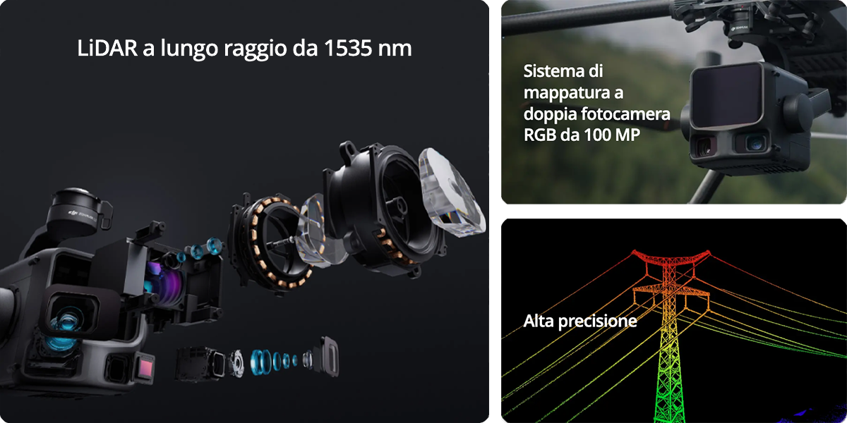
Long-range LiDAR
and dual 100 MP camera
The L3 isn't a simple upgrade: it's a new generation. Laser 1535 nm (not the 905 nm of the L2) for quadrupled range and superior penetration. Dual RGB 100 megapixel camera — not single 20 MP — for tripled photogrammetric resolution and effective coverage. Combined acquisition in flight.
LiDAR 1535 nm + POS
Class 1 eye-safe laser with 1535 nm wavelength and high-precision POS system. Range up to 2000 meters and superior penetration compared to traditional 905 nm LiDAR even in intense ambient light.
- Range 950m (10%) / 2000m (80%)
- Up to 2 million points per second
- Multi-return: up to 16 echoes per pulse
- Beam divergence 0.25 mrad
- POS heading 0.02° post-processed
- Ranging repeatability 5 mm @ 150m
Dual 100 MP camera
CMOS 4/3 dual-camera system with mechanical shutter. Simultaneous acquisition of high-resolution photogrammetric data alongside LiDAR scanning. Colored point clouds with real texture and extended lateral coverage.
- Dual CMOS 4/3 100 MP sensor
- Mechanical shutter (no rolling shutter)
- GSD 3 cm @ 300m nadir altitude
- Combined LiDAR + RGB output
- Photorealistic 3D models
- Integrated DJI Terra workflow
Eye-safe.
Four times farther.
The L3's 1535 nm wavelength is eye-safe (retina insensitive to that frequency) and enables significantly higher emission powers compared to the 905 nm of the L2 — hence range reaching 2000 meters at 80% reflectivity (approximately 4× the L2). In challenging 10% reflectivity conditions it maintains 950 meters. Combined with up to 16 returns per pulse (vs 5 of the L2), it penetrates dense vegetation, multi-layer urban environments, and complex structures like no other DJI Zenmuse payload.
Want to see the L3 on your corridor project?
One LiDAR,
three adaptive patterns
An exclusive novelty of the L3 in the Zenmuse family: three scan modes selectable in flight. Point distribution adapts to the scenario — uniform terrain, forests with dense canopy, complex vertical structures. Get the right geometry on the first acquisition.
Uniform distribution
Regular point distribution on the terrain. The default mode for topographic mapping and modeling of extensive surfaces.
- Uniform terrain mapping
- Precision DTM / DSM
- Construction sites and corridors
- Topographic surveys
Penetration balance
Stellar pattern balancing geometric precision and penetration capacity. Ideal for forestry scenarios — maximizes useful returns through canopies.
- Forestry management
- Canopy penetration
- Vegetation classification
- Biomass inventories
Multi-angle coverage
Non-repetitive pattern with extended multi-angle coverage. Ideal for structures with complex vertical geometry — pylons, transmission towers, bridges.
- Pylons and power lines
- Bridges and vertical infrastructure
- Towers and complex structures
- 360° inspections
Long-range LiDAR
on real projects
The L3 in operation: corridor mapping of long power lines and pipelines, topographic surveys of large areas, multi-layer infrastructure inspection, forest mapping with biomass analysis. Demo at our Rimini office or at your real site with complete processing on DJI Terra.
Six next-generation
technologies
Not an L2 iteration: a category leap. 1535 nm laser instead of 905 nm, 16 returns instead of 5, dual 100 MP camera instead of single 20 MP, certified survey-grade accuracy, professional CFexpress storage. For surveys that previously required planes or helicopters.
1535 nm long-range LiDAR
Class 1 eye-safe 1535 nm laser. Range up to 2000 meters and superior penetration of traditional 905 nm LiDAR even in intense ambient light conditions.
16 returns per pulse
Multi-return up to 16 echoes/pulse — 3× compared to L2. Exceptional penetration of dense vegetation, multi-layer urban environments, structures with complex geometry.
Dual 100 MP camera
Dual RGB CMOS 4/3 100 megapixel camera with mechanical shutter. Photogrammetric acquisition simultaneous with LiDAR scanning for high-resolution textured 3D models.
Survey-grade accuracy
3 cm vertical at 120m, 5 cm at 300m, 10 cm at 500m. Ranging repeatability 5 mm at 150m. POS 0.02° heading, 0.01° pitch post-processed — professional survey standard.
IP54 · 1.60 kg
Resistant to dust and water splashes for field operations. Compact 1.60 kg weight compatible with Matrice 400 operational autonomy. DJI SKYPORT connector on port E1.
CFexpress Type B
CFexpress Type B storage ≥1500 MB/s required to manage combined LiDAR + dual-camera 100 MP data flow. Output in professional formats: LAS, LAZ, PLY, PCD, S3MB, PNTS.
Eight fields
where scale changes everything
Eight Italian fields where 100 km²/day, 16 returns per pulse, and 2000 m range transform weeks of aerial campaigns into single-day operations. Corridor mapping, topography, forestry, critical infrastructure, extractive activities, cultural heritage.
Your project is on this list. Let's talk.
From first flight
to survey-grade deliverable
DJI Gold 5 Dealer, ISO 9001:2015 certified. Advanced training on long-range LiDAR and 3 scan modes, DJI Terra consulting for 1535 nm point cloud post-processing, integration with LiDAR360/Metashape/CAD/GIS, MEPA for Public Administrations, DJI Care Enterprise Plus 1 year included in the price.
Professional LiDAR training
Dedicated training on 1535 nm laser, 3 scan modes (Linear/Stellar/Non-Repetitive), corridor mapping planning, POS post-processing workflow.
DJI Terra consulting
Advanced L3 post-processing setup and optimization on DJI Terra. 2M pts/s point cloud handling, vegetation classification, survey-grade DTM/DSM.
MEPA & Public Administration supply
Available on MEPA for public bodies, forestry consortia, utility and energy networks, cadastre/urban planning PA. Tender support.
24h shipping
Delivery across Italy within 24 hours of order. Professional packaging for safe transport of 1.60 kg IP54 LiDAR payload.
DJI Care Enterprise Plus
Included 1 year in purchase price: protection against accidental damage, unit replacement, priority technical support, rapid repair. Renewable.
CAD/GIS integration
Output LAS/LAZ/PLY/PCD/S3MB/PNTS with workflow integration for LiDAR360, Agisoft Metashape, CloudCompare, Autodesk ReCap, Bentley ContextCapture, ESRI ArcGIS Pro.
Complete pipeline
with D-RTK 3 positioning
DJI Pilot 2 for LiDAR mission planning, RC Plus with 7" HD screen, DJI Terra as photogrammetric and LiDAR post-processing engine, DJI Modify for 3D model editing, D-RTK 3 for high-precision RTK positioning — fundamental to achieve L3 survey-grade accuracy.
DJI Pilot 2
RC Plus
DJI Terra
DJI Modify
D-RTK 3
Let's talk
about your next long-range project
We help you evaluate the L3 for your specific workflow: corridor mapping of power lines and pipelines, extensive topographic surveys, selection of the appropriate scan mode, integration with Matrice 400 fleet and D-RTK 3, DJI Terra consulting and LAS/LAZ output. Demo at our Rimini office or at your real site. Fill out the form and we'll reply within 48h. Or call us at +39 0541.1790411.
Iper-Ammortamento
+ Nuova Sabatini
The Zenmuse L3 qualifies as an eligible Industry 4.0 capital good when paired with an enterprise platform meeting interconnection requirements (Matrice 400). Full cumulability between Iper-Ammortamento and Nuova Sabatini: up to 50-60% total recovery on the integrated drone + LiDAR payload + DJI Terra software + D-RTK 3 system. Technical 4.0 documentation included. Available on MEPA for surveying studios, engineers, forestry consortia, utilities, and public bodies.
Learn moreLease your Zenmuse L3
Zero down payment · Response within 48h · All-Risk insurance included · 24 to 60 month terms · 100% tax deductible on each installment · Final buyout option · Also available on MEPA
Request a personalized quote


