
Fly.
Process.
Deliver.
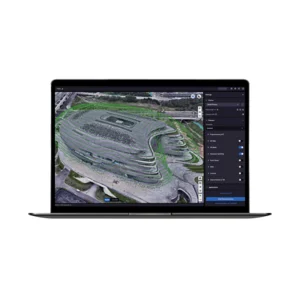
The official DJI software that transforms drone data into 2D orthomosaics, textured 3D models, LiDAR reconstructions, Gaussian Splatting, and multispectral analysis. Complete workflow from flight planning to professional output, natively integrated with Matrice 400, Matrice 4D/4TD, Matrice 350 RTK, Mavic 3 Enterprise, and Zenmuse P1/L2/L3 payloads. From €1,875.99 (Standard annual license) to €13,068.01 (Flagship + Modify Permanent).
Standard, Flagship,
Modify: pick the right tier
DJI Terra is available in three progressive editions: Standard for basic photogrammetry and LiDAR workflows, Flagship for enterprise projects with Gaussian Splatting and Electricity module, Modify for advanced 3D model editing. Annual or permanent licenses, online or offline, multi-device support.
DJI Terra Standard
The base edition for topographic surveys, cadastral mapping, and mid-scale inspections. Covers 2D orthophotos, textured 3D reconstruction, LiDAR processing, and multispectral analysis.
From €1,875.99/1 year- High-resolution 2D orthomosaics
- Textured 3D models (mesh)
- Integrated LiDAR processing
- Multispectral analysis
- Permanent version from €5,323.99
- Offline mode available
DJI Terra Flagship
The top edition for large-scale projects. Standard + Gaussian Splatting (photorealistic neural reconstruction), Electricity module for utility inspection, support for up to 10 concurrent devices.
From €3,812.00/1 year- Everything in Standard
- Gaussian Splatting (AI reconstruction)
- Electricity module (utility inspection)
- Multi-device up to 10 workstations
- Permanent version from €10,910.00
- Upgrade from Standard from €6,151.00
DJI Modify Flagship
Companion editor to Terra for cleanup, optimization, and finalization of 3D models. Automatic tools for noise removal, gap filling, and mesh optimization for final client delivery.
€3,610.00/permanent- Advanced 3D model editing
- Automatic noise removal
- Gap filling and mesh optimization
- Texture cleanup and enhancements
- Lifetime permanent license
- Bundle with Flagship: €13,068.01
From flight plan
to final deliverable
DJI Terra covers the entire pipeline of the survey professional: automated mission planning with waypoints, corridor mapping, oblique, terrain follow; local or dedicated workstation processing of photos and LiDAR point clouds; multi-format export in LAS/LAZ, TIFF, OBJ, PLY, DSM/DTM for direct integration in AutoCAD, QGIS, ArcGIS, Revit, 3DS Max. Natively integrated with DJI Enterprise drones and Zenmuse payloads without intermediate steps.
Not sure which license is right for you? We’ll guide you.
Four outputs,
one unified software
DJI Terra is not a converter: it’s an integrated workflow that produces accurate 2D maps, textured 3D models, classified LiDAR reconstructions, and — with Flagship — neural Gaussian Splatting reconstructions with photographic visual quality. Each output is immediately usable in professional BIM, GIS, and CAD workflows.
High-resolution orthomosaics
Georeferenced orthophotos with centimeter precision via RTK, automatic DSM and DTM, NDVI vegetation index in both Standard and Flagship editions. GeoTIFF outputs ready for QGIS, ArcGIS, AutoCAD Map 3D. Workflow optimized for cadastral surveys, municipal mapping, agricultural inspections.
Textured 3D models
Photorealistic 3D meshes with high-resolution textures. Automated workflow from photo selection to OBJ/PLY/OSGB export. Direct integration in 3DS Max, Blender, Revit, Cesium for digital twins and BIM/AR applications.
Classified point clouds
Native processing of Zenmuse L2 / L3 LiDAR data: density, automatic classification (ground, vegetation, buildings, power lines), RGB coloring from integrated camera. Industry-standard LAS/LAZ output. Photogrammetry + LiDAR data fusion for maximum accuracy.
Photorealistic AI reconstruction
Next-generation neural 3D reconstruction (Flagship novelty). Visual quality superior to traditional mesh methods, perfect for architectural visualizations, cultural heritage, client presentations. Output compatible with modern web viewers.
DJI Terra
in real production
DJI Terra in action on Italian projects: topographic surveys, photogrammetric reconstructions of construction sites, bridge inspections, quarry monitoring, multispectral agricultural mapping, cultural heritage digitization. Operational demo at our Rimini office or personalized webinar with your sample data.
Six technologies
for data professionals
DJI Terra combines proprietary DJI algorithms with modern processing architectures: Gaussian Splatting AI, native LiDAR workflow, integrated multispectral analysis, Electricity module for utility inspections, multi-device support up to 10 workstations, offline mode for remote sites and enterprise data security.
Gaussian Splatting AI
Neural 3D reconstruction with 3D Gaussian Splatting technique (Flagship novelty). Photorealistic visual quality superior to traditional meshes. The future of 3D visualization from drone data — available today on DJI Terra.
Native LiDAR
Direct processing of Zenmuse L2 / L3 point clouds. Automatic ground/vegetation/building classification, ground filtering, DTM generation from point cloud. Photo + LiDAR fusion for ultra-accurate hybrid models.
Multispectral
Native processing of Mavic 3 Multispectral data and compatible sensors. Automatic NDVI, NDRE, GNDVI vegetation indices. Crop status analysis, water stress identification, cultivated area mapping for precision agriculture.
Electricity Module · Flagship
Dedicated module for utility inspection: automatic power line extraction from LiDAR point cloud, safety clearance calculation, identification of vegetation in conflict zones, automatic reports for grid operators. Dedicated workflow for utility grid operators.
Multi-device · 10 workstations
Flagship license with multi-device support up to 10 concurrent workstations. A single license for the entire engineering firm team, GIS department, or construction site survey division. Centralized activation management.
Offline Mode
Offline Standard and Flagship versions for processing in areas without connection, enterprise data sovereignty, operation in remote construction sites. Zero cloud dependency, full control of sensitive data.
Eight sectors
where Terra is the standard
DJI Terra is adopted in Italy by engineering firms, topographic surveying companies, public administrations, cultural heritage authorities, utilities, quarry and mining operators, agricultural consortia, and forensic services. Eight fields where the software is today the professional benchmark for drone data.
Want to see Terra on your real workflow?
License consulting,
training, onboarding
DJI Gold 5 Dealer certified ISO 9001:2015. Terra has 12 license variants across Standard, Flagship, Modify, annual or permanent, online or offline. We help you pick the right combination for your specific workflow, offer operational training on the software, and complete onboarding from first datasets to first production deliverables.
License selection consulting
Analysis of your current workflow and goals: project types, number of operators, offline needs, target outputs. Optimal license proposal among the 12 available variants, without excessive purchases.
Operational training
Software training from flight planning to deliverable export. Dedicated modules for Standard, Flagship, Modify, and Electricity module. In-person training at our office or remote via webinar.
Dataset onboarding
Support on your first real projects: flight plan review, raw dataset validation, processing parameter optimization, review of first deliverables delivered to client.
MEPA & Public Administration supply
Available on MEPA (Italian Public Administration marketplace) for Public Administrations, cadastral offices, cultural heritage authorities, agricultural consortia, utilities. Public tender documentation support and multi-license framework contracts.
Dedicated hardware
Workstations optimized for Terra processing: multi-core CPUs, dedicated GPUs for Gaussian Splatting, high-capacity NVMe storage. We recommend the configuration suited to your project type.
Continuous technical support
Dedicated technical consultant for your account. Assistance on difficult processing, troubleshooting problematic datasets, software version updates, migration from other photogrammetry software.
Natively integrated
with the entire DJI lineup
DJI Terra natively processes data from DJI Enterprise aerial platforms and Zenmuse payloads: Matrice 400 and Matrice 4D/4TD for large-scale projects, Matrice 350 RTK as industry benchmark, Mavic 3 Enterprise for agile surveys, Zenmuse P1/L2/L3 for professional-grade photogrammetry and LiDAR precision.
Matrice 400 / 4D/4TD
Matrice 350 RTK
Zenmuse P1 · L2 · L3
DJI Pilot 2
Multi-device
Let’s talk
about your Terra workflow
We help you choose among the 12 DJI Terra variants on your specific scenario: engineering firm, surveying company, public administration, cultural heritage authority, utility, quarry operator, agricultural consortium, forensic service. Consulting on optimal Standard/Flagship/Modify combination, operational training, onboarding on real datasets. On-site demo at our Rimini office or personalized webinar. Fill out the form and we’ll contact you within 48h. Or call us at +39 0541.1790411.
Italian Hyper-Depreciation
+ Nuova Sabatini
DJI Terra software qualifies as an interconnected Industry 4.0 asset when paired with a DJI Enterprise drone + payload: software-driven system with digitized outputs, integration with corporate BIM/GIS workflows, native data analytics. Cumulability between Hyper-Depreciation and Nuova Sabatini on the integrated drone + payload + Terra system — total recovery up to 50-60% on the investment. Technical 4.0 documentation included. Available on MEPA for Public Administrations, cadastral offices, cultural heritage authorities, utilities, and consortia.
Learn how it worksPick your Terra license
Starting from €1,875.99 for Terra Standard annual, up to €13,068.01 for the Flagship + Modify Permanent bundle. Twelve license variants: Standard/Flagship/Modify, annual or permanent, online or offline, Educational 10-device edition. We help you choose the right one — no excessive purchases, no unnecessary subscriptions.
View all 12 variants Request consulting


