
Plan.
Precise.
First flight.
The most complete solution for professional flight planning — LiDAR, photogrammetry, corridor mapping, vertical scan and much more. Precision data collection on the first flight, no repeats. Compatible with nearly any drone: from DJI to US-made platforms. Enterprise-level customisation and automation. More than 4,000 survey, inspection and mapping teams worldwide rely on UgCS every day.
Open, Pro or Enterprise:
choose the right license.
UgCS is available in three tiers: UgCS Open to get started and experience advanced features with limited usage, UgCS Pro for professional teams with full access to all planning modules, and UgCS Enterprise for enterprise operators with fleet management, APIs and advanced GIS integrations.
UgCS Open
The entry point for those who want to discover UgCS. Flight planning with limited usage — perfect for evaluating features before upgrading to the Pro license.
Available in the shop- Basic area and corridor planning
- Terrain following included
- Limited monthly usage
- DJI and multi-drone compatibility
- Community support
- Ideal for evaluation and testing
UgCS Pro
The license for professional survey and inspection teams: full access to all 12 planning tools, unlimited routes, unlimited segments, KML/CSV import, vertical scan, orbit and Circlegrammetry.
On request/license- All 12 flight planning tools
- Unlimited segments and waypoints per route
- Automatic KML and CSV import
- Vertical scan · Orbit · Circlegrammetry
- Advanced LiDAR planning
- DroneBase technical support included
UgCS Enterprise
For operators with multiple fleets and corporate GIS/BIM integration needs: centralised fleet management, REST API, ArcGIS/QGIS connectors, advanced data analytics and dedicated SLA.
On request/fleet- Centralised fleet management
- REST API for system integration
- ArcGIS · QGIS · AutoCAD connectors
- Multi-user and multi-device
- Dedicated SLA and priority support
- Available on MEPA for Public Admin
The terrain follows
your drone.
Anyone mapping complex terrain knows the challenge is not taking off — it's maintaining constant relative altitude over slopes, canyons, power lines, valleys and steep hillsides. UgCS features the industry's best terrain following algorithm: adjust the resolution and slope of the reference surface, fly near-vertical surfaces using Smart AGL, and ensure consistent data quality over any terrain type. The result: uniform LiDAR point clouds and photogrammetric datasets, with no low-density zones or irregular overlaps. Precision on the first flight — no repeats.
Already using DJI Pilot 2? See what UgCS adds to your workflow.
Six tools.
One platform.
UgCS combines traditional flight planning with advanced tools designed for complex professional use cases: high-density LiDAR, oblique photogrammetry, linear infrastructure inspection, vertical scanning of facades and towers. Every module is optimised to maximise data quality and reduce mission time.
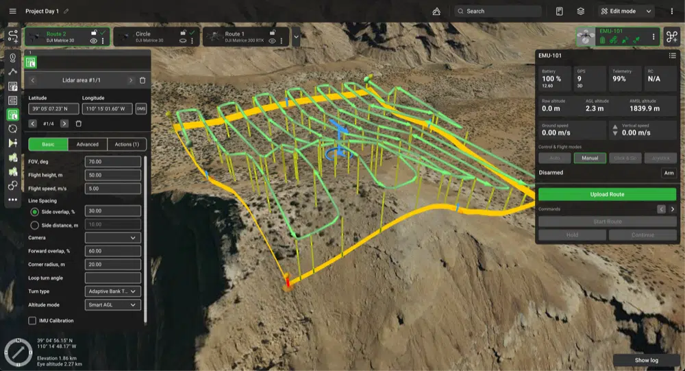
Advanced LiDAR missions
Specialised planning for LiDAR sensors: automatic calculation of the optimal flight pattern for target point density, overlap configuration, speed and altitude based on the specific sensor. Compatible with Zenmuse L2/L3, Hesai, Livox and other professional LiDAR payloads.
Corridor mapping
Optimised routes for linear infrastructure: gas pipelines, power lines, roads, railways, waterways. Direct import from shapefile, KML or CSV. Automatic terrain following along the corridor axis to maintain constant AGL even on sections with significant elevation change.
Vertical scan
Inspection of vertical surfaces: building facades, dams, wind turbines, pylons, rock faces. The flight plan is generated perpendicular to the target surface with configurable overlap and GSD. A tool absent from DJI Pilot 2, exclusive to UgCS Pro.
Photogrammetric orbit
Planning of photogrammetric orbits around isolated subjects (historic buildings, towers, silos, antennas, monumental trees): multiple angles, configurable radius, altitude and overlap. Generates 360° 3D models with full coverage of all facades. Exclusive UgCS tool.
Three times more tools.
Zero compromises.
DJI Pilot 2 is great for standard flights. But for complex projects, professional LiDAR, long corridors, vertical scans and multi-segment routes, UgCS offers a level of control and customisation that DJI Pilot 2 simply cannot match. The recommended workflow for DJI drones: UgCS desktop planning + execution in DJI Pilot 2.
| Feature | UgCS Pro | DJI Pilot 2 |
|---|---|---|
| Basic route creation | ✓ Full | ✓ Basic |
| Suitable for large / complex projects | ✓ Optimised | ✗ Limited |
| Route customisation | Full | Limited |
| Flight planning tools | 12 tool | 4 tool |
| Automatic import from files | KML + CSV | KML only |
| Segments per route | Unlimited | Only 1 |
| Waypoint type | Waypoint, area or linear | Basic area |
| Preview multiple routes side-by-side | ✓ | ✗ |
| Circlegrammetry tool | ✓ | ✗ |
| Vertical scan tool | ✓ | ✗ |
| Orbit flights avanzati | ✓ | ✗ |
| Multi-manufacturer compatibility | DJI · FreeFly · Inspired · Blue UAS | DJI only |
Built for those who
accept no compromises.
UgCS was built from the ground up as a multi-platform solution for professional flight planning. It is not a plugin or extension — it is full desktop software with planning engines, adaptive terrain following, automatic GSD calculation, GIS file import and DJI Pilot 2 integration for direct execution on DJI drones.
Smart AGL Terrain Following
Industry-leading terrain following algorithm. Adjust the resolution and slope of the reference surface, fly near-vertical surfaces with Smart AGL. Maintains constant AGL over any terrain type — slopes, canyons, valleys, cliffs.
LiDAR Mission Planning
Automatic flight plan calculation for LiDAR sensors: target point density, optimal pattern, speed and AGL based on the sensor. Compatible with Zenmuse L2, L3, Hesai, Livox. LAS/LAZ output ready for post-processing.
Import KML · CSV · Shapefile
Automatically generate routes from existing GIS files: polygon shapefiles, area-of-interest KML, CSV with coordinate lists. Zero manual drawing — import the geometry and UgCS calculates the optimal flight plan with the chosen parameters.
Multi-route preview
Compare multiple alternative routes side-by-side before takeoff: view flight time, distance, number of photos, estimated overlap and battery consumption for each option. Choose the optimal plan based on objective data, not guesswork.
DJI Pilot 2 Integration
Plan on UgCS desktop, execute in DJI Pilot 2. The recommended workflow for DJI drones: leverage UgCS planning power (12 tools, unlimited routes, advanced terrain following) and the reliable execution of DJI Pilot 2. The best of both ecosystems.
Multi-platform · Blue UAS
UgCS supports nearly all professional drones: DJI Matrice, FreeFly Alta X, Inspired Flight IF1200A and many others from the Blue UAS list. One software for the entire fleet — regardless of drone manufacturer.
From quarries to coastlines.
UgCS flies everywhere.
UgCS is adopted by topographic survey teams, infrastructure inspection, environmental monitoring, emergency response, archaeology and industrial digital twin operations. Eight sectors where flight plan quality determines data quality — and where getting it wrong means flying again.
Ready to take your flight planning to the next level?
Setup, training &
workflow integration.
DJI Gold 5 Dealer certified ISO 9001:2015. UgCS integrates seamlessly with DJI drones, Zenmuse payloads and DJI Terra processing software. We support you from choosing the right license to full operational readiness on your first real project.
License consulting
Analysis of your scenario: mission types, drone in use, budget, frequency of use. Recommendation of the most suitable license among Open, Pro and Enterprise. Support during trial evaluation before final purchase.
Flight planning training
Hands-on training on UgCS: area and corridor planning, terrain following, LiDAR planning, vertical scan, Circlegrammetry, KML/CSV import, export for DJI Pilot 2. In-person at our Rimini office or remote webinar using your own real dataset.
UgCS + Terra integration
Full workflow setup UgCS → DJI Pilot 2 → DJI Terra: desktop planning, execution in Pilot 2, 3D processing in Terra. The end-to-end pipeline for DJI LiDAR and photogrammetric surveys with maximum quality and zero incompatibilities.
Recommended hardware
Workstations optimised for large-area planning: multi-core CPU for complex route calculation, GPU for 3D terrain rendering, SSD for high-resolution DTM, connectivity for GIS dataset import. Recommended configuration based on your workflow.
MEPA & Public Admin supply
Available on MEPA for Public Administrations, cadastral offices, cultural heritage authorities, Civil Protection, universities and research centres. Support for public tender documentation and multi-license Enterprise framework contracts.
Ongoing technical support
Dedicated consultant for your account. Support on complex missions, terrain following troubleshooting, LiDAR planning configuration, GIS integration, software updates and migration from other platforms (Pix4D, DroneDeploy, Mission Planner).
The complete workflow
from plan to deliverable
UgCS fits as the advanced planning frontend in the DJI Enterprise ecosystem: plan on UgCS desktop, execute in DJI Pilot 2 with a Matrice drone, process data in DJI Terra, and deliver clean outputs with DJI Modify. A seamless flow — zero software incompatibilities, zero data loss between steps. Also available as a standalone platform for non-DJI fleets (FreeFly, Inspired Flight, Blue UAS).
UgCS Desktop Planning
DJI Pilot 2 Execution
Matrice 400 / 350 RTK
DJI Terra Processing
DJI Modify Delivery
Let's talk about your
next flight project.
We help you choose the right UgCS license for your scenario: topography, LiDAR, inspections, corridor mapping, cultural heritage, Civil Protection. We verify compatibility with your drone and recommend the optimal purchase path (Open/Pro/Enterprise). Buy directly from the shop or call us at 0541.1790411 to speak with an expert.
Transition Plan 5.0
+ Nuova Sabatini
UgCS, combined with DJI Enterprise drones and LiDAR/photogrammetric payloads, qualifies for the Italian Transition Plan 5.0 and Nuova Sabatini incentives: software-driven workflows with structured digital outputs, integration with corporate BIM/GIS systems, structured geospatial data collection. Incentives can be combined on the complete system — technical documentation included. Available on MEPA for Public Administrations, cadastral offices, cultural heritage authorities and Civil Protection.
Learn about incentivesUgCS — Buy in the Shop
Choose the UgCS license that best suits your workflow: Open to get started, Pro for professional teams with full access to all 12 tools (LiDAR, corridor, vertical scan, Circlegrammetry, unlimited routes), Enterprise for fleets with fleet management and API. Purchase directly from the DroneBase shop — DJI Gold 5 Dealer certified ISO 9001:2015.
Buy UgCS 📞 0541.1790411


