Public Security

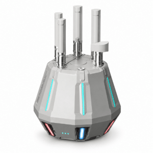
Argus Drone Detection System

Passive station for drone detection, identification and tracking up to 8 km with 360° coverage, based on Remote ID signal reception.

  • Detection on 2.4 and 5.8 GHz with response time under 1 second
  • Brand, model, serial number, coordinates, altitude, speed and pilot position when broadcast
  • ADS-B and AIS reception for a single air and maritime picture
  • Blacklist and whitelist management with targeted alarms
  • Track playback and reconstruction of take-off, landing and pilot position
  • Fully passive detection, no electromagnetic emissions
  • IP66, -30°C to +55°C, powered from 220 V mains, PoE, 12 V power bank or solar
  • Management software included, web and mobile app
Argus Drone Detection System
Price on request
Invoicing available at check-out
VAT-FREE
Tax-Free Shopping For EU businesses registered in VIES
↗
Talk to an expert Dedicated technical consultant — Mon–Fri 9:00 AM–6:00 PM
Call
Register now → ACCESS DISCOUNTS
Register now and get exclusive discounts on all products. Reserved prices are visible only to registered users.
Access the Reserved Pricing
Airspace surveillance · DroneBaseArgus Drone Detection System

Passive station for drone detection, identification and tracking up to 8 km with 360° coverage. It receives Remote ID signals on the 2.4 and 5.8 GHz bands and returns, in under one second, the brand, model, serial number, position, altitude and speed of the drone and, when broadcast, the pilot’s position. It also integrates ADS-B and AIS reception, blacklist and whitelist management and perimeter protection with radar and audio-visual alarm. Management software included.

8 kmDetection Range 360°Omnidirectional Coverage <1 sResponse Time IP66Protection Rating
How it worksDetect, identify, locate, track, alert

The Argus Drone Detection System works in receive mode only: it listens for the Remote ID signals broadcast by drones, decodes them and makes them available in real time in the management software, building a picture of the low-altitude situation across the monitored area.

01 · DetectPassive 360° receptionHigh-gain directional antennas cover the full horizon up to 8 km and flag the presence of a drone in less than one second
02 · IdentifyBrand, model and serial numberDecoded Remote ID data shows which drone is flying and allows it to be checked against the authorisation lists
03 · LocateDrone and pilot on the mapCoordinates, altitude, heading and speed of the drone and, when present in the received signal, the pilot’s position
04 · TrackTracking and playbackReal-time trajectories, playback of recorded tracks and report generation from the management software
05 · AlertTargeted alarmsAlerts on blacklisted drones, no alarm for whitelisted ones, colour-coded map icons for immediate reading
06 · RespondDock linkageWith the optional software platform, an alternative to DJI FlightHub 2, the system points to the nearest dock to send a drone to the pilot’s position and document the event
Why choose itKey benefits

A single compact unit to monitor the low-altitude airspace of airports, critical infrastructure, industrial sites and events: long-range detection, immediate identification of drones broadcasting Remote ID, continuous 24/7 operation and no radio emissions that could interfere with the surrounding electromagnetic environment.

Up to 8 km, 360°Directional antennas with gain up to 12 dBi and omnidirectional coverage to monitor extensive areas with a single station
Fully passive detectionThe unit operates in receive mode only and emits no electromagnetic signals: no impact on the surrounding radio environment
Remotely adjustable antennasAn internal servo mechanism adjusts antenna tilt from 0 to 15° via software, reducing blind spots and compensating for low installations
Protection of the unit itselfMillimetre-wave radar with a 10 m range, red-blue strobe and loudspeaker: anyone approaching the station triggers the audio-visual alarm and a software notification
Drones, aircraft and vesselsBeyond Remote ID it receives ADS-B from manned aircraft and AIS from vessels, for a single picture of the airspace and maritime situation
Deploy anywhere, 24/7Powered from 220 V mains, PoE, a 12 V power bank or a solar panel; mounted on a pole, tripod, magnetic base or suction cup, including on a vehicle
The productArgus Drone Detection System: a passive drone detection system for low-altitude surveillance

The Argus Drone Detection System is a passive drone detection system built for organisations that need to know, at any moment, which drones are flying over or around a sensitive site. The unit receives the Remote ID messages broadcast by drones on the 2.4 GHz and 5.8 GHz bands and, thanks to directional antennas with 360° coverage, detects aircraft up to 8 km away with a response time of less than one second. For every identified drone it provides brand, model, serial number, heading, coordinates, altitude and speed, plus the pilot’s position when this is contained in the received signal.

The included management software, accessible from a web browser and a mobile app, displays drones on the map with colour-coded icons, manages blacklists and whitelists so that alarms are raised only for unauthorised drones, stores the track history and produces reports. The same interface brings together ADS-B data from manned aircraft and AIS data from vessels, with theoretical ranges of 200 km and 100 km respectively, along with environmental data from an optional weather module. With the optional software platform, an alternative to DJI FlightHub 2, the station can be linked to docks to send a drone towards the pilot’s position and gather documentation of the event.

The station is built in ABS with an IP66 protection rating, weighs about 5 kg and operates from -30°C to +55°C. It can be powered from 220 V mains, PoE, a 12 V power bank or a solar panel, and communicates via 4G, Wi-Fi, Ethernet and Bluetooth, with multi-constellation GNSS positioning. A millimetre-wave radar, a red-blue strobe and a loudspeaker protect the unit against unauthorised approaches within 10 m. The system is dedicated to detection, identification and alerting, and can serve as the surveillance layer of a wider counter-drone architecture. Distributed by DroneBase, DJI Gold 5 Dealer certified ISO 9001:2015, with pre- and post-sales technical support, installation and operator training. Explore also the DJI Matrice 400 range available from DroneBase.

The softwareFrom detection to reconstructing the event

The station produces data; the included software turns it into something usable by whoever has to decide and, when needed, document. Accessible from a web browser and a mobile app, with direct access to the unit over the local network even without connectivity.

Real-time alertingThe Remote ID signal is decoded and checked against lists and airspace rules: identity, position and track appear on the map with graded alerts
Track playbackThe drone’s path is replayed on the map along a timeline with coordinates, altitude, speed, heading and timestamp, with fast-forward, slow motion and point-by-point review
Backward reconstructionFrom the recorded track the system works back to the take-off point, the landing point and the pilot’s position, correlating drone identity and recorded history
Authorisation listsAuthorised drones go on the whitelist by serial number and unique identifier and raise no alarm; models and aircraft to be flagged go on the blacklist, with immediate alert and positioning
Analysis and reportsStatistics on unauthorised overflights with pie and bar charts and density maps, to identify the most critical areas and time bands
Mobile app and local accessReal-time data, track history and reports from a smartphone; with no network available the unit remains accessible directly over the local network
Technical specificationsFull technical specifications
DRONE DETECTION
TechnologyPassive reception of Remote ID signals
Detection rangeUp to 8 km
Coverage360° omnidirectional
Response timeLess than 1 s
Data returnedBrand, model, serial number, heading, latitude and longitude, altitude, speed, pilot position when broadcast
Stand-alone detectionSupported, also without connection to other stations
FREQUENCIES AND ANTENNAS
Received frequencies2.4 GHz · 5.8 GHz · 1.09 GHz · 162 MHz
Antenna typeDirectional
Antenna gainUp to 12 dBi
Standing wave ratioNot exceeding 2
Antenna tilt0–15°, remotely adjustable via internal servo mechanism
MULTI-SOURCE RECEPTION
ADS-BSupported — 200 km range (theoretical figure)
AISSupported — 100 km range (theoretical figure)
Weather dataExpansion module interface provided
PERIMETER PROTECTION OF THE UNIT
Proximity radarRange up to 10 m
Proximity alarmSupported, audio and visual with software notification
Strobe lightRed and blue, up to 30 W
Status lightRGB, colour changes according to the detected target
CONNECTIVITY AND SOFTWARE
Communication4G, Wi-Fi, Ethernet, Bluetooth
GNSSGPS, BeiDou, Galileo, GLONASS, QZSS
ControlWeb version and mobile app
Software functionsReal-time map, blacklist and whitelist, alarms, unit operating parameters, track playback, reports
Dock linkageVia optional software platform, an alternative to DJI FlightHub 2
POWER SUPPLY
Modes220 V mains, PoE, 12 V power bank, solar panel
Rated powerUp to 100 W
Surge protectionSupported
PHYSICAL AND ENVIRONMENTAL
Dimensions302 × 311 × 320 mm
Weight5 kg ± 50 g
MaterialABS
Protection ratingIP66
Operating temperature-30°C / +55°C
Storage temperature-35°C / +70°C
INSTALLATION
Deployment modesFixed, mobile, vehicle-mounted
Compatible mountsFixed pole, tripod, magnetic base, suction cup
In the boxWhat’s included
Argus Drone Detection System
IP66 detection unit with integrated directional antennas
220 V power supply unit
For operation from mains power
Connection cables
Cabling for installing the unit
Pole mount
Bracket for fixed pole installation
Software licence
Management software accessible from web and mobile app
Who it is forApplication sectors
Airports and heliportsDetection of drones in approach and take-off areas, with ADS-B aircraft traffic shown on the same map
Critical infrastructurePower plants, substations, water facilities and strategic sites with continuous round-the-clock surveillance
Ports and coastal areasMonitoring of drones over quays and terminals, combined with AIS reception from vessels in transit
Events and public gatheringsTemporary installation on a tripod or vehicle to monitor the airspace during concerts, sporting events and ceremonies
Public safetySupport for security operators in locating drones and pilots and gathering data useful for managing the event
Industrial sites and private perimetersProtection of plants, depots and restricted areas from unauthorised overflights and unwanted filming
Frequently asked questionsFAQ
Which drones does the Argus Drone Detection System detect?
The station detects and identifies drones that broadcast a Remote ID signal on the 2.4 GHz and 5.8 GHz bands. For each one it provides brand, model, serial number, position, altitude, heading and speed, plus the pilot’s position when this is included in the broadcast signal.
How far away can it detect a drone?
The detection range reaches up to 8 km with 360° coverage. The actual distance depends on the strength of the signal emitted by the drone, the installation height of the station, any obstacles present and the radio conditions at the site.
Does it also detect drones that do not broadcast Remote ID?
No. Detection relies on receiving the Remote ID signal the drone broadcasts: an aircraft that does not broadcast it is not detected. That is the trade-off of passive detection, which in exchange emits nothing and does not interfere with the site’s radio environment. Where non-cooperative aircraft also have to be covered, Argus is the identification layer to pair with sensors of a different nature.
Does the station emit signals or disturb communications?
No. Detection is fully passive: the unit works in receive mode only and emits no electromagnetic signals, so it does not interfere with the radios and systems operating in the area.
Can it neutralise a drone?
No. The Argus Drone Detection System handles detection, identification, localisation and alerting. It can act as the surveillance layer of a wider counter-drone architecture, but it performs no jamming or other neutralisation actions.
Is the software included? How does dock linkage work?
The management software licence, usable from a web browser and a mobile app, is included in the supply. Linkage with docks, which allows a drone to be sent towards the pilot’s position, instead requires an optional software platform that replaces DJI FlightHub 2.
How is it powered and installed?
The station can be powered from 220 V mains using the included power supply unit, or via PoE, a 12 V power bank or a solar panel, with rated power up to 100 W. It installs on a pole using the included mount, or on a tripod, magnetic base or suction cup, including on board a vehicle. The IP66 protection rating and the -30°C to +55°C operating range allow continuous outdoor use.
What do ADS-B and AIS reception add?
Beyond drones, the station receives ADS-B signals broadcast by manned aircraft and AIS signals broadcast by vessels, with theoretical ranges of 200 km and 100 km respectively. This data appears in the software alongside detected drones and gives a single picture of the air and maritime situation around the site.
What support does DroneBase provide?
DroneBase, a DJI Gold 5 Dealer and ISO 9001:2015 certified company, provides pre- and post-sales technical support, advice on station positioning, installation, software configuration and operator training.
Argus Drone Detection System — Available from DroneBase

Detection up to 8 km · 360° coverage · Response under 1 s · Remote ID, ADS-B and AIS · Passive detection · IP66 · Management software included

★ DJI Gold 5 DealerISO 9001:2015Passive detectionRemote ID · ADS-B · AIS


Based on 0 reviews

0.0 overall
0
0
0
0
0

Be the first to review “Argus Drone Detection System”

There are no reviews yet.

Why DroneBase

The partner that neverleaves you grounded.

01 — Warranty
Official DJI Warranty
12-month full warranty on original product. Certified purchase from a DJI Gold 5 dealer.
02 — Logistics
24h Express Shipping
Orders placed by 1:00 PM ship the same day. Trackable throughout Italy. Professional packaging.
03 — Support
Dedicated Technical Support
Certified consultant assigned to your account. Unlimited pre- and post-sales support.
04 — Purchase
Free 14-Day Returns
Satisfied or refunded within 14 days of delivery. No-questions-asked policy, full refund.
Tax Incentives 2026

Buy professional drones.Recover up to 60% of your investment.

In 2026, stackable tax tools are active that significantly reduce the effective cost. Available for companies, self-employed professionals and public administration.

01 — Transition 4.0 Plan
Hyper Depreciation
Enhanced tax deduction for technologically advanced capital goods. Directly reduces the IRES/IRPEF taxable base.
+180% deduction up to €2.5M
Learn how it works →
02 — Italian Law Decree 69/2013
Nuova Sabatini
Non-repayable interest contribution on financing or leasing. Reduces credit costs to nearly zero.
Non-repayable grant Active until 2029
Check requirements →
03 — Stackability
Stackable Savings
The two instruments operate on separate levels and can be combined. On a €20,000 enterprise system you can recover up to €10,000–12,000.
50–60% recovery Stackable 2026
Request a simulation →
Technical 4.0 documentation support included. DroneBase assists you with the technical appraisal and interconnection requirements needed to access Hyper Depreciation.
Tax incentive details →
Grenke Leasing
Choose the GrenkeOperating Lease!
  1. 1Add the product to your cart
  2. 2Select Operating Lease as the purchase method
  3. 3Select the monthly payment based on your preferred term (24–60 months)
  4. 4Submit your non-binding request
  5. 5Response within 48h
Discover why leasing makes sense →

Questions about this product?

Fill out the form and one of our experts will get back to you shortly.

Request Information

Option
Privacy Policy
Newsletter

Stay up to date

DJI product news, exclusive offers and tutorials from our experts.

Certified DJI Gold Dealer and ISO 9001:2015. Enterprise drone solutions for Italian professionals.

DroneBase SRL
Via San Giovenale 86
47922 Rimini — Italy
P.IVA IT04456990409 · REA RN-413198
ISO 9001:2015 Certified
DJI Gold Dealer ★★★★★
Trustpilot 4.8/5 Based on real reviews

© 2026 DroneBase SRL — All rights reserved · P.IVA IT04456990409

Visa, Mastercard, PayPal, Bank transfer, GrenkeLeasing