3D Lidar

GoSLAM X1 – Drone SLAM Scanner for Indoor and Confined Space Inspection

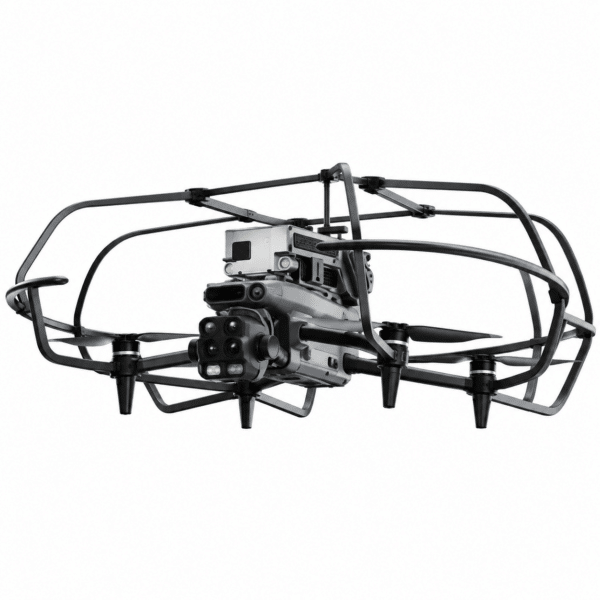
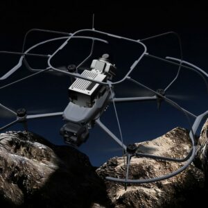
SLAM laser scanner in an anti-collision cage, plug & play on the DJI Matrice 4E and Matrice 4T, for 3D surveying of tunnels, tanks, underground spaces and confined spaces.

  • 360° × 59° scanning field at 200,000 points per second
  • Stated accuracy up to 1 cm, range up to 70 m
  • No GPS required: positioning built by the SLAM algorithm
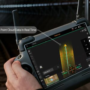
  • Real-time colour point cloud, visible on the remote controller during flight
  • Quick-mount anti-collision cage, 72 × 65 × 23 cm footprint
  • Break-point resume with automatic alignment, unlimited resumes
  • 128 GB TF card and integrated 5G module for remote viewing
  • Post-processing software, 3D Gaussian reconstruction and viewer included
drone slam matrice 4 goslam x1 5g
7.185,80  7.564,00  TAX (22%) Included
Invoicing available at check-out
Yours from 158,91 €/month with Grenke Operating Lease
VAT-FREE
Tax-Free Shopping For EU businesses registered in VIES
Talk to an expert Dedicated technical consultant — Mon–Fri 9:00 AM–6:00 PM
Call
Register now → ACCESS DISCOUNTS
Register now and get exclusive discounts on all products. Reserved prices are visible only to registered users.
Access the Reserved Pricing
Airborne 3D laser scanning · DroneBaseGoSLAM X1 – Drone SLAM Scanner for Indoor and Confined Space Inspection

SLAM laser scanner in an anti-collision cage, plug & play on the DJI Matrice 4E and Matrice 4T: one connector, no external control unit, no second remote controller. Fly inside tunnels, tanks, ducts and underground spaces and come back with a colour point cloud built while you are still flying, with accuracy up to 1 cm and 200,000 points per second. No scaffolding, no personnel entering the confined space.

1 cmScanning Accuracy 200,000 pt/sAcquisition Rate 360°×59°Scanning Field 72 cmWidth with Cage
In depthThe full system presentation

The comparison with a traditional confined space survey, the step-by-step workflow, the data produced and the eight environments where the system is used.

How it worksFrom mounting to point cloud in four steps

The scanner plugs into the drone’s dedicated connector: power, data, scanning commands and the spotlight all run through the aircraft, with no additional control units and no second remote controller to manage.

Step 01Plug in and cage upThe scanner connects to the dedicated port on the Matrice 4E or 4T with no tools and no control units. The quick-mount anti-collision cage brings the overall footprint to 72 × 65 × 23 cm
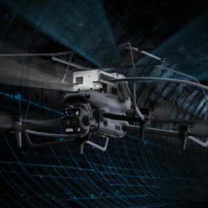
Step 02Fly and scan with SLAMNo GPS required: the SLAM algorithm builds the map as the drone moves, with a 360° × 59° scanning field and 200,000 points per second. The front spotlight is controlled from the remote
Step 03Check coverage on the remoteThe point cloud appears on the remote controller screen during the flight: the pilot judges the coverage achieved and corrects the trajectory on the spot, with no external equipment
Step 04Output and post-processingData is recorded on board on a 128 GB card and, in the connected version, transmitted in real time. Post-processing refines density and accuracy for measurement applications
Why choose itKey benefits

In a confined space the difference is not made by the sensor datasheet. It is made by the footprint, the available light, the freedom to make a mistake without breaking anything, and the certainty that everything has been captured before landing.

Anti-collision cageThe quick-mount frame encloses the drone on every side: in a duct or inside a tank, contact with the wall is designed for rather than feared
360° × 59° coverageThe sensor captures the full ring around the drone as it moves: walls, vault and floor all enter the same pass, where dozens of static stations would otherwise be needed
Colour in real timeA 5 MP global shutter image sensor fused with the laser: the cloud comes out already in colour and at uniform density, with no separate colourisation stage
Break-point resumeWhen the scene cannot be covered in a single flight, scanning resumes from the interruption point: swap batteries without losing alignment, with no manual stitching and no limit on the number of resumes
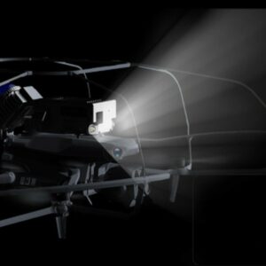
Controllable lightingA dedicated front spotlight, adjustable from the remote controller, serves two purposes at once: seeing where you are flying and producing clean images for the cloud’s colour rendering
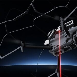
Laser control pointsReference points are captured by laser aiming and used for coordinate conversion: no targets to carry, place and retrieve in an environment nobody enters
The productGoSLAM X1: airborne 3D laser scanning for tunnels, tanks and underground spaces

The GoSLAM X1 is a drone SLAM scanner for the three-dimensional survey of enclosed environments and confined spaces. The laser scanner plugs into the dedicated connector of the DJI Matrice 4E and Matrice 4T: power, data, scanning commands and the spotlight all run through the aircraft, so no external control units, extra cabling or second remote controller are required. The SLAM algorithm reconstructs position from the sensor’s own perception, with no GPS signal needed, which is exactly why the system works inside tunnels, underground spaces and closed structures.

Acquisition runs with a 360° × 59° scanning field and a rate of 200,000 points per second, with stated accuracy up to 1 cm and a range from 40 m at 10% reflectivity to 70 m at 80% reflectivity. A 5 MP global shutter image sensor is fused with the laser and produces a colour point cloud during the flight itself, visible on the remote controller screen: the pilot sees the coverage achieved and corrects the trajectory on the spot. The quick-mount anti-collision cage encloses the drone on every side and brings the overall footprint to 72 × 65 × 23 cm, the dimension that decides whether a passage can be flown. Break-point resume lets the crew stop, change batteries and continue from the interruption point, with automatic alignment and no limit on the number of resumes.

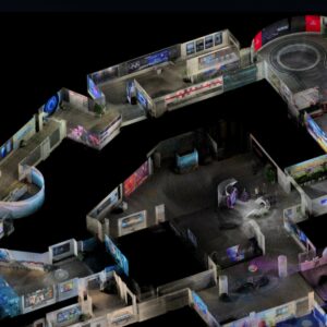
Data is recorded on board on a 128 GB TF card and, in the connected version with integrated 5G module, the cloud can be viewed and measured remotely while acquisition is still under way. The included software covers high-precision post-processing, 3D Gaussian reconstruction and a dedicated viewer; the output is a point cloud that fits into existing CAD and BIM workflows. The system comes in two configurations: the SLAM Scanner Kit for fleets that already operate a Matrice 4E or 4T, or the Matrice 4T Combo with drone, batteries, guards and operational training. Supplied by DroneBase, DJI Gold 5 Dealer certified ISO 9001:2015, with preliminary site assessment, field commissioning, operational training, EASA/ENAC documentation support and ongoing assistance. The DJI Matrice 400 range is also available from DroneBase.

ConfigurationsTwo configurations: with or without the drone

If a DJI Matrice 4E or 4T is already in the fleet, only the scanning kit is needed. Otherwise the starting point is the complete combo with the Matrice 4T, radiometric thermal camera included. During the demo we assess together which of the two suits your environments and your survey frequency.

You already own the droneSLAM Scanner Kit

For fleets that already operate a DJI Matrice 4E or 4T. It plugs into the drone’s dedicated connector and adds 3D laser scanning capability in confined spaces, with all the processing software included. Drone not included.

  • 1× 3D SLAM LiDAR scanner with integrated 5G module
  • 1× Quick-mount anti-collision cage
  • 1× Card reader
  • 1× 128 GB TF card
  • 8× M3×6 hand-tighten screws
  • 2× Spare soft rubber pads
  • 1× Lens cleaning cloth
  • 1× Point cloud post-processing software licence
  • 1× Desktop processing software, standard version
  • 1× 3D viewer
  • 1× Hard safety case for transport

Operational training covers mounting, calibration, a first guided acquisition and verification of the parameters on your type of environment, in Rimini or at your premises. Operating lease from 24 to 60 months and supply through MEPA for Italian public bodies are both available.

Technical specificationsFull technical specifications
SCANNING SYSTEM
TechnologySLAM scanning, no GPS required
Scanning field360° × 59°
Acquisition rate200,000 points per second
Scanning accuracyUp to 1 cm
Scanning range40 m at 10% reflectivity · 70 m at 80% reflectivity
Control pointsCaptured by laser aiming, for coordinate conversion and reference planes
IMAGING AND COLOUR
Image sensor5 MP with global shutter
Cloud colourisationCamera-laser fusion with synchronous colour rendering, colour in real time
LightingDedicated front spotlight, adjustable from the remote controller
OPERATIONAL FUNCTIONS
Cloud previewLive display on the remote controller screen, no additional equipment
Break-point resumeSupported, unlimited number of resumes, automatic alignment
ControlsScanning and spotlight managed from the drone remote controller
Operating enduranceApproximately 15 minutes per section, with scanner and cage fitted
DATA, SOFTWARE AND TRANSMISSION
On-board storage128 GB TF card
5G transmissionIntegrated module, connected version with remote viewing and measurement during acquisition
ProcessingReal-time colour plus high-precision post-processing
Reconstruction3D Gaussian technique with dedicated viewer
OutputColour point cloud at uniform density, usable in CAD and BIM workflows
DIMENSIONS AND OPERATING CONDITIONS
Overall footprint72 × 65 × 23 cm, anti-collision frame included
Anti-collision cageQuick-mount, encloses the drone on every side
Operating temperature-20°C / +50°C
Operating environmentsInteriors, tunnels, tanks, underground spaces, ducts
COMPATIBILITY
Supported dronesDJI Matrice 4E, DJI Matrice 4T
InterfaceDirect connection to the drone’s dedicated port, plug & play
Additional equipmentNo external control unit, no second remote controller, no extra cabling
DJI MATRICE 4T — COMBO CONFIGURATION ONLY
Thermal cameraUncooled VOx 640 × 512, up to 1280 × 1024 at 30 fps in super-resolution
Thermal range-20°C / +550°C, accuracy ±2°C or ±2% in High Gain
OpticsWide, medium tele and tele · 48 MP with hybrid zoom up to 112×
Laser rangefinderUp to 1800 m at 20% reflectivity, 1 m blind zone
NIR auxiliary lightUp to 100 m, vision in total darkness
Drone flight timeUp to 49 minutes in standard configuration, without scanner and cage
Operating rangeUp to 25 km, O4 Enterprise transmission
Take-off weight1219 g with standard propellers
Protection ratingIP55
ClassificationC2 marking, subcategory A2
Who it is forApplication sectors
TunnelsThe full length in a single pass, with comparison between successive campaigns to track deformation and spalling
Tanks and silosInternal volume, wall condition and residual geometry without the time and constraints of a confined space entry
Underground spaces and ductsService rooms, shafts, conduits and inspection passages that neither people nor wheeled vehicles can reach
Mines and quarriesProduction galleries, faces and excavation chambers, with volumes calculated directly from the cloud
Industrial interiorsWarehouses, plants and production lines: as-built survey for revamping projects and layout redefinition
Stockpiles and storageVolumetric measurement of covered deposits, bulk materials and enclosed warehouses
Emergency and post-eventUnstable structures after fire, collapse or flooding: the geometry captured before crews are sent in
Heritage and archaeologyCrypts, vaults, hypogeal spaces and historic structures, surveyed without scaffolding and without contact
Frequently asked questionsFAQ
Which drones does it mount on, and how complex is it?
The kit is compatible with the DJI Matrice 4E and Matrice 4T and is fully plug & play: it connects to the drone’s dedicated port, and power, data, scanning commands and the spotlight all run through it. No external control unit, no second remote controller, no cabling to build. With the Matrice 4T the same flight also brings back thermal data.
Is GPS needed for scanning to work?
No. Positioning is built by the SLAM algorithm from the sensor’s own perception during flight: that is exactly why the system works in tunnels, underground spaces and closed structures where satellite signal does not reach.
What is the narrowest passage it can fly through?
The overall footprint with the anti-collision frame is 72 × 65 × 23 cm. The usable passage has to be assessed case by case, because beyond the cross-section it also depends on protruding obstacles, air flows and the manoeuvring margin the pilot needs. It is one of the first things we check together during the site assessment.
What accuracy is actually achieved in the field?
The manufacturer states accuracy up to 1 cm. The real figure depends on the geometry of the environment, flight speed, surface reflectivity and the quality of post-processing. For applications with strict metric requirements, a trial in your specific environment before purchase is worthwhile.
Are fifteen minutes of flight enough for a long tunnel?
For a single section, yes; for an extended length the survey proceeds in several passes. Break-point resume allows the crew to stop, change batteries and continue from the interruption point: the scans align automatically, with no manual stitching and no limit on the number of resumes.
Is a specialised pilot required?
A pilot certified under EU Regulation 2019/947 and comfortable flying in tight spaces is required. Scan management, on the other hand, is integrated into the remote controller: no second operator and no additional control unit. Staff training is part of the DroneBase delivery process.
Is the data compatible with our software?
The output is a point cloud, so it fits into the CAD and BIM workflows already in use. Exact formats and export options depend on the software configuration chosen: we verify them against your workflow before the order.
Is there a real-time transmission version?
Yes. The 5G module is integrated into the scanner, and in the connected configuration the colour cloud can be viewed and measured remotely while acquisition is under way, through the dedicated cloud platform. It is the mode designed for emergency coordination and remote works supervision.
Which of the two configurations makes sense?
If a Matrice 4E or 4T is already in the fleet, only the SLAM Scanner Kit is needed. Otherwise the Matrice 4T Combo brings drone, batteries, guards and operational training in a single supply, plus the radiometric thermal camera that returns a thermal map of the environment on the same flight. During the demo we assess together which one suits your environments and survey frequency.
What support does DroneBase provide?
DroneBase, a DJI Gold 5 Dealer and ISO 9001:2015 certified company, covers the whole path: preliminary site assessment, configuration and field commissioning with your staff, operational training, support with EASA/ENAC documentation and D-Flight registration, and ongoing assistance with an assigned technical contact, software updates and spare parts.
GoSLAM X1 — Available from DroneBase

Accuracy up to 1 cm · 200,000 pt/s · 360° × 59° field · Real-time colour cloud · 72 × 65 × 23 cm anti-collision cage · Plug & play on DJI Matrice 4E and 4T · Integrated 5G module

View the full presentation
★ DJI Gold 5 DealerISO 9001:2015No GPS requiredOperational training included

Based on 0 reviews

0.0 overall
0
0
0
0
0

Be the first to review “GoSLAM X1 – Drone SLAM Scanner for Indoor and Confined Space Inspection”

There are no reviews yet.

Why DroneBase

The partner that neverleaves you grounded.

01 — Warranty
Official DJI Warranty
12-month full warranty on original product. Certified purchase from a DJI Gold 5 dealer.
02 — Logistics
24h Express Shipping
Orders placed by 1:00 PM ship the same day. Trackable throughout Italy. Professional packaging.
03 — Support
Dedicated Technical Support
Certified consultant assigned to your account. Unlimited pre- and post-sales support.
04 — Purchase
Free 14-Day Returns
Satisfied or refunded within 14 days of delivery. No-questions-asked policy, full refund.
Tax Incentives 2026

Buy professional drones.Recover up to 60% of your investment.

In 2026, stackable tax tools are active that significantly reduce the effective cost. Available for companies, self-employed professionals and public administration.

01 — Transition 4.0 Plan
Hyper Depreciation
Enhanced tax deduction for technologically advanced capital goods. Directly reduces the IRES/IRPEF taxable base.
+180% deduction up to €2.5M
Learn how it works →
02 — Italian Law Decree 69/2013
Nuova Sabatini
Non-repayable interest contribution on financing or leasing. Reduces credit costs to nearly zero.
Non-repayable grant Active until 2029
Check requirements →
03 — Stackability
Stackable Savings
The two instruments operate on separate levels and can be combined. On a €20,000 enterprise system you can recover up to €10,000–12,000.
50–60% recovery Stackable 2026
Request a simulation →
Technical 4.0 documentation support included. DroneBase assists you with the technical appraisal and interconnection requirements needed to access Hyper Depreciation.
Tax incentive details →
Grenke Leasing
Choose the GrenkeOperating Lease!
  1. 1Add the product to your cart
  2. 2Select Operating Lease as the purchase method
  3. 3Select the monthly payment based on your preferred term (24–60 months)
  4. 4Submit your non-binding request
  5. 5Response within 48h
Discover why leasing makes sense →

Questions about this product?

Fill out the form and one of our experts will get back to you shortly.

Request Information

Opzione
Privacy Policy
Newsletter

Stay up to date

DJI product news, exclusive offers and tutorials from our experts.

Certified DJI Gold Dealer and ISO 9001:2015. Enterprise drone solutions for Italian professionals.

DroneBase SRL
Via San Giovenale 86
47922 Rimini — Italy
P.IVA IT04456990409 · REA RN-413198
ISO 9001:2015 Certified
DJI Gold Dealer ★★★★★
Trustpilot 4.8/5 Based on real reviews

© 2026 DroneBase SRL — All rights reserved · P.IVA IT04456990409

Visa, Mastercard, PayPal, Bank transfer, GrenkeLeasing