
3D Lidar Combo
Showing all 2 results
-
✓ Pronta consegna3D Lidar Combo, Combo
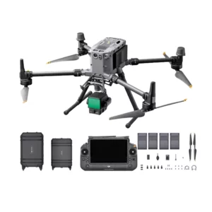
DJI Matrice 350 + Zenmuse L2 3D Lidar Combo
Integrated 3D Lidar system with Zenmuse L2 and Matrice 350 RTK for professional aerial scanning of bridges, infrastructure and large structures. Includes drone, BS65 charging station, batteries and Terra Pro software. Available at DroneBase, DJI Gold 5 Dealer.
SKU: DJM351-CL2 -
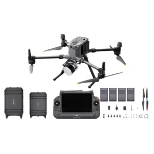
✓ Pronta consegna3D Lidar Combo, Combo
DJI Lidar Matrice 350 + TopoDrone Lidar 100+ Combo.
Complete M350 Lidar system with TopoDrone 100+ and RTK precision for professional 3D scanning of infrastructure and large structures. Includes drone, charging station and 4 TB65 batteries. Available at DroneBase, DJI Gold 5 Dealer.
SKU: DJM351-CTDL100
Advanced 3D Lidar Technology for Professional Applications
Our 3D Lidar combo solutions represent the cutting edge of aerial surveying technology. These integrated systems combine DJI's proven Matrice 350 platform with state-of-the-art Lidar payloads, delivering millimeter-accurate point cloud data for construction, mining, forestry, and infrastructure inspection projects.
Each combo package includes pre-calibrated sensors, professional software licenses, and comprehensive training materials to ensure immediate deployment capability for your surveying operations.
Matrice 350 Platform Advantages for Lidar Operations
The DJI Matrice 350 serves as the ideal platform for professional Lidar operations, featuring IP55 weather resistance, dual battery systems for extended flight times, and precision hovering capabilities essential for accurate data collection. The aircraft's robust design handles payload weights up to 2.7kg while maintaining stability in challenging weather conditions.
TopoDrone Lidar 100+ Integration Benefits
The TopoDrone Lidar 100+ offers exceptional versatility for surveying applications, featuring customizable scanning patterns and real-time data processing capabilities. This system excels in vegetation penetration for forestry applications and provides survey-grade accuracy suitable for cadastral mapping and construction site monitoring.
Integration with popular GIS software platforms ensures seamless workflow integration for surveying professionals requiring immediate data processing and analysis capabilities.
DJI Zenmuse L2 Professional Features
The Zenmuse L2 represents DJI's most advanced Lidar solution, incorporating a high-precision IMU system and integrated 20MP RGB camera for photogrammetry fusion. This system delivers exceptional point cloud density and accuracy, making it ideal for detailed infrastructure inspection and precision mapping applications.
Software Integration and Workflow Solutions
Our Lidar combos include comprehensive software packages for data processing and analysis. DJI Terra compatibility ensures seamless point cloud processing, while third-party software integration supports advanced modeling and analysis workflows required by surveying professionals.
Cloud-based processing options enable teams to handle large datasets efficiently, with automated classification and feature extraction capabilities that significantly reduce post-processing time requirements.
Professional Training and Support Services
DroneBase provides comprehensive training programs covering both hardware operation and software workflows. Our ISO 9001:2015 certified processes ensure consistent support quality, with ongoing technical assistance available for complex mapping projects and advanced application development.
Why buy from DroneBase
DJI Gold 5 Dealer Status
Highest tier DJI partnership ensures priority access to latest technology and comprehensive technical support.
ISO 9001:2015 Certified
Quality management certification guarantees consistent service delivery and professional support standards.
Complete Turnkey Solutions
Pre-configured combos with integrated training reduce deployment time and ensure immediate operational capability.
Italian Technical Expertise
Local support team in Rimini provides personalized assistance and rapid response for mission-critical operations.
Frequently asked questions
3D Lidar combo pricing varies based on payload selection and software requirements. Contact our Rimini office for detailed quotations including training, warranty coverage, and ongoing support services tailored to your specific mapping applications.
Commercial Lidar operations require appropriate drone pilot certification and may need additional permits depending on your operational area. DroneBase provides guidance on regulatory compliance and can recommend certified training providers for professional drone operations.
Both TopoDrone Lidar 100+ and Zenmuse L2 systems deliver centimeter-level accuracy under optimal conditions. Actual precision depends on flight altitude, ground control points, and environmental factors. Our technical team can provide specific accuracy specifications for your application requirements.
Primary applications include construction progress monitoring, mining volume calculations, forestry management, power line inspection, and archaeological surveys. These systems excel in any application requiring precise topographical data or vegetation penetration capabilities.
Processing time varies with dataset size and complexity. Real-time preview capabilities allow immediate data validation, while full processing typically completes within hours using DJI Terra or specialized Lidar software. Cloud processing options can significantly reduce local processing requirements.
Standard packages include operational training covering flight planning, data collection procedures, and basic processing workflows. Advanced training modules cover specialized applications and integration with professional surveying software platforms.
Want a consultation or a demo?
Our DJI Enterprise certified technicians help you choose the right configuration. No commitment.
+39 0541 1790411


