
- Advanced mission planning: Define specific waypoints, altitudes and actions for each segment of the flight.
- Multi-sensor support: Easily integrate cameras, LiDAR and other sensors to capture diverse data.
- Extended compatibility: Works with numerous drone models, offering operational flexibility.
- 3D terrain planning: Use 3D maps for accurate planning in complex environments.
- Photogrammetry and mapping: Create detailed orthomosaics and 3D models for topographic surveys.
- Industrial inspections: Monitors infrastructure such as power lines, pipelines and plants.
- Precision agriculture: Analyze crop status and optimize agricultural resources.
Featured products

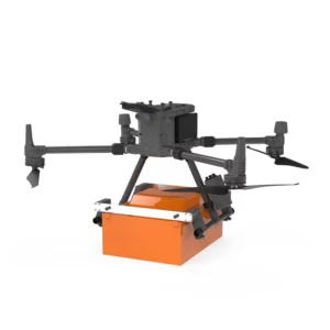
Georadar Drone - Zond Aero 1000 NG GPR
Ultra-lightweight GPR system for geophysical and archaeological surveying on DJI Matrice 300/350. Single unit with Ethernet and WiFi connect
Georadar Drone - Zond Aero 500 NG
Ultralight single-unit GPR for advanced geophysical surveying on DJI Matrice 300/350. Real-time profile visualisation and WiFi/Ethernet conn

UgCS Commander-SPH
Professional software for simultaneous control of drone fleets with automated missions. Manages multiple UAVs concurrently whilst optimising
UgCS - SPH
Showing all 6 results
-
✓ Pronta consegnaMagnetometer, UgCS - SPH
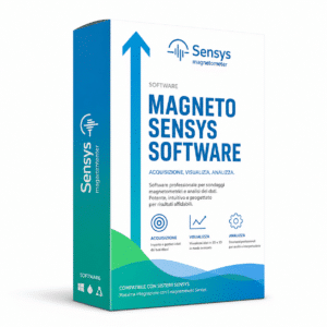
SENSYS MAGNETO® Desktop | Magnetic Data Analysis Software
The SENSYS MAGNETO® Desktop is the professional SENSYS GmbH software for the comprehensive analysis of magnetic and electromagnetic data from area and borehole surveys. Automatic calculation of position and size of suspicious objects, color-coded maps, multi-dataset management, integrated text editor for reporting. Standard for UXO, archaeology, geophysics and offshore investigations. Compatible with the entire SENSYS ecosystem (MagDrone, MagWalk, MX, BM2). DroneBase is official reseller.
SKU: IS-SENSYS-MAGNETO -
✓ Pronta consegnaGeoradar, Georadar & Magnetometer Combo, UgCS - SPH
Georadar Drone – Zond Aero 1000 NG GPR
Ultra-lightweight GPR system for geophysical and archaeological surveying on DJI Matrice 300/350. Single unit with Ethernet and WiFi connectivity for real-time analysis. Available at DroneBase, DJI Gold 5 Dealer.
SKU: n/a -
✓ Pronta consegna
-
✓ Pronta consegna


Professional Ground Penetrating Radar Technology
UgCS SPH systems represent the cutting edge of airborne ground penetrating radar technology. These specialized drone-mounted georadar solutions enable non-invasive subsurface investigations across archaeological sites, utility infrastructure, and geological formations. The Zond Aero series delivers exceptional penetration capabilities while maintaining flight safety and operational efficiency.
Our georadar drones combine advanced GPR sensors with precision flight control systems, ensuring accurate data collection even in challenging environments. The integration of UgCS mission planning software provides seamless workflow management from flight planning to data analysis.
Zond Aero 1000 NG GPR Specifications
The Zond Aero 1000 NG GPR system operates at 1000 MHz frequency, providing exceptional resolution for shallow subsurface investigations up to 3 meters depth. This high-frequency configuration excels in archaeological surveys, concrete inspection, and utility mapping where detailed structural information is critical.
Advanced signal processing algorithms enhance target detection capabilities while reducing noise interference. The system's lightweight design ensures compatibility with professional drone platforms while maintaining extended flight endurance for comprehensive survey coverage.
Zond Aero 500 NG Capabilities
Operating at 500 MHz frequency, the Zond Aero 500 NG offers deeper penetration capabilities up to 5 meters while maintaining excellent resolution for mid-depth investigations. This configuration proves ideal for geological surveys, environmental monitoring, and infrastructure assessment applications.
The system's enhanced signal processing capabilities ensure reliable target detection in various soil conditions and geological formations. Integrated GPS positioning provides precise georeferencing for accurate subsurface mapping and analysis.
UgCS Commander-SPH Software Integration
UgCS Commander-SPH provides comprehensive mission planning and data management capabilities specifically designed for georadar operations. The software streamlines flight planning, data acquisition, and post-processing workflows to maximize operational efficiency and data quality.
Real-time data visualization enables immediate assessment of survey progress and data quality during flight operations. Advanced analysis tools support detailed interpretation of GPR data, generating professional reports and 3D subsurface models for client deliverables.
Applications and Use Cases
UgCS SPH systems serve diverse professional applications including archaeological site investigation, utility infrastructure mapping, and geological survey operations. These systems excel in non-invasive subsurface exploration where traditional excavation methods prove impractical or potentially damaging.
Environmental consultants utilize these systems for contamination assessment and groundwater studies, while engineering firms deploy them for foundation analysis and structural inspection. The technology's versatility extends to mining exploration, pipeline inspection, and forensic investigation applications.
Why buy from DroneBase
DJI Gold 5 Partner
Authorized elite dealer status ensuring authentic products and comprehensive technical support.
ISO 9001:2015 Certified
Quality management certification guarantees consistent service excellence and reliability.
Enterprise Focus
Specialized expertise in professional-grade georadar solutions and applications.
Italian Excellence
Based in Rimini with deep understanding of European market requirements.
Frequently asked questions
The Zond Aero 1000 NG penetrates up to 3 meters with high resolution, while the Zond Aero 500 NG reaches up to 5 meters depth. Actual penetration depends on soil conditions, moisture content, and target characteristics.
Pricing varies based on configuration and included components. Contact our team for detailed quotations on Zond Aero systems and UgCS Commander-SPH software packages tailored to your specific requirements.
UgCS Commander-SPH requires a professional license for commercial operations. We provide licensing options including annual subscriptions and perpetual licenses with maintenance packages.
Zond Aero systems integrate with professional DJI platforms including Matrice series drones. Our technical team ensures proper integration and certification for your specific platform requirements.
Archaeological surveys, utility mapping, geological investigations, concrete inspection, and environmental monitoring represent primary applications. The technology excels in non-invasive subsurface exploration scenarios.
Accuracy depends on frequency selection and environmental conditions. The 1000 MHz system provides centimeter-level resolution for shallow targets, while the 500 MHz offers excellent mid-depth accuracy with integrated GPS positioning.
Want a consultation or a demo?
Our DJI Enterprise certified technicians help you choose the right configuration. No commitment.
+39 0541 1790411


