DJI Zenmuse P1 — 45 MP Full-Frame Camera for Aerial Photogrammetry, Topographic Surveys and 3D Modelling
The DJI Zenmuse P1 is the reference payload for professional aerial photogrammetry: 45 MP full-frame sensor with interchangeable DL lens system, 3-axis stabilised gimbal, Smart Oblique Capture for optimised oblique missions and TimeSync 2.0 for microsecond-level synchronisation between camera, RTK module and gimbal. Compatible with the DJI Matrice 350 RTK and Matrice 400, it produces orthophotos, DSMs and 3D models with centimetre-level absolute accuracy in combination with the drone's integrated RTK module. It is the solution of choice for surveyors, engineers, architecture firms and GIS operators who require the highest image quality and metric precision in a compact payload. Available for immediate delivery from DroneBase with technical support and DJI Care included.
Explore the available configurations
The Zenmuse P1 is available on its own or with DJI Care Enterprise coverage to protect your investment.
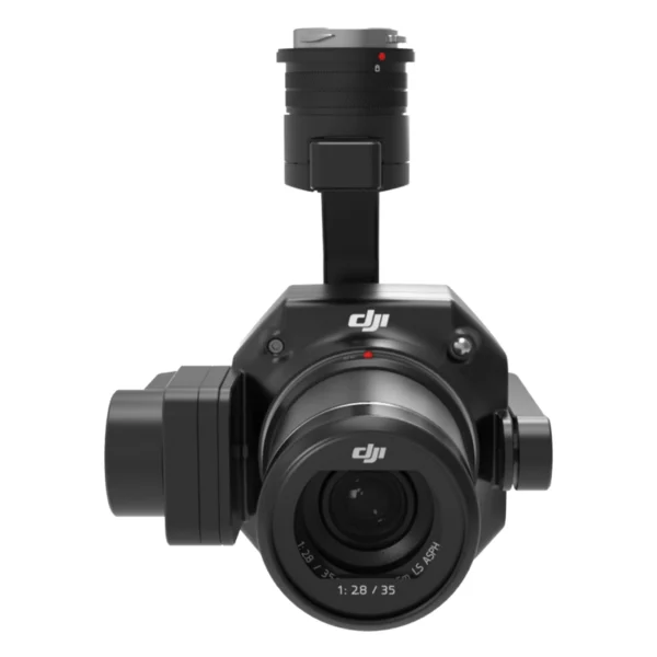
DJI Zenmuse P1
45 MP full-frame sensor, 3-axis gimbal, Smart Oblique Capture and TimeSync 2.0. The reference payload for photogrammetry, surveying and 3D modelling on the M350 RTK and M400.
- 45 MP full-frame
- 3-axis gimbal
- TimeSync 2.0
P1 + Care Enterprise Basic
DJI Care Enterprise Basic coverage for the Zenmuse P1: replacement in case of accidental damage, priority support and maintenance interventions. Essential protection for your payload.
- 1 year coverage
- Accidental damage
- Priority support
P1 + Care Enterprise Plus
DJI Care Enterprise Plus coverage for the Zenmuse P1: comprehensive protection including total loss, rapid payload replacement and maximum operational continuity for those who cannot afford downtime.
- Full coverage
- Loss included
- Rapid replacement
DJI Zenmuse P1 Gimbal
Showing all 5 results
-
✓ Ready to shipDJI Matrice 350 RTK series, DJI Matrice 400, DJI Zenmuse P1 Gimbal
DJI Zenmuse P1
45 MP Full-Frame sensor with 3cm horizontal/5cm vertical accuracy without GCP for professional photogrammetry. Covers up to 3 km² in a single flight with 3-axis gimbal and TimeSync 2.0. Available at DroneBase, DJI Gold 5 Dealer.
SKU: DJZP02 -
✓ Ready to ship
-
✓ Ready to ship
-
✓ Ready to ship
-
✓ Ready to ship

What is the DJI Zenmuse P1 and why it is the reference payload for professional aerial photogrammetry
The DJI Zenmuse P1 is DJI's flagship photogrammetric payload, designed for professionals who cannot compromise on image quality and metric precision. It mounts a 45 MP full-frame sensor — the largest format available on a DJI drone payload — with an interchangeable DL lens system (24 mm, 35 mm, 50 mm) that allows selection of the focal length best suited to the flight altitude and the Ground Sample Distance (GSD) required by the project. In combination with the RTK module of the Matrice 350 RTK or the Matrice 400, the Zenmuse P1 produces orthophotos, 3D models and DSMs with centimetre-level absolute accuracy without ground control points, drastically reducing field time compared to traditional GCP-based workflows.
45 MP full-frame sensor — the image quality that makes the difference in photogrammetry
The full-frame (35 mm) format of the Zenmuse P1 sensor offers a significantly larger light-capturing surface than the 4/3" or 1" sensors used on other DJI payloads. In photogrammetry this translates into three concrete advantages: finer GSD at the same flight altitude (fewer pixels per metre = greater detail), superior dynamic range to manage scenes with strong contrasts (deep shadows and brightly lit areas), and edge sharpness critical for the precision of measurements on tie points between frames. With the DL 35 mm lens at 120 m altitude, the GSD is below 2.5 cm/pixel — sufficient for the vast majority of professional topographic surveys.
Smart Oblique Capture — efficient oblique photogrammetry with fewer images
The Smart Oblique Capture function optimises oblique photogrammetry missions — those in which the drone captures images with the gimbal tilted laterally to capture the vertical facades of buildings and structures, essential for urban 3D modelling, vertical infrastructure surveying and reconstruction of non-horizontal surfaces. Unlike the traditional method which requires 5 separate passes (nadir + 4 obliques), the P1's Smart Oblique Capture reduces by up to 40% the number of images needed for the same coverage quality, shortening flight time and accelerating processing in DJI Terra.
TimeSync 2.0 — microsecond synchronisation for absolute accuracy
The precision of a photogrammetric survey depends not only on sensor quality but on the synchronisation between the moment of exposure and the GPS/RTK position of the drone at that precise instant. The Zenmuse P1's TimeSync 2.0 system synchronises at microsecond level the timestamps of the camera, RTK module, gimbal and drone IMU, eliminating positioning errors caused by temporal jitter between systems. The result is that every acquired image carries a precision RTK geotag that enables photogrammetric processing without GCPs with certifiable centimetre-level accuracy.
Interchangeable DL lens system — 24 mm, 35 mm and 50 mm
The Zenmuse P1 supports DJI's DL Mount lens system with three available focal lengths:
DL 24 mm f/2.8 LS ASPH — maximum ground coverage
The ideal wide-angle lens for surveys of large areas (quarries, water bodies, industrial areas, extensive agricultural land) where swath coverage per pass is prioritised over ground resolution. At 150 m altitude it covers approximately 140 × 93 m per image with a GSD of around 2.6 cm/pixel.
DL 35 mm f/2.8 LS ASPH — optimal balance
The reference focal length for the majority of professional topographic surveys: optimal balance between ground coverage and resolution, with minimal distortion at the edges of the frame. It is the recommended choice for cadastral surveys, urban orthophotos and BIM models.
DL 50 mm f/2.8 LS ASPH — maximum resolution
The lens for surveys requiring the finest GSD over limited areas: structural inspections, detailed architectural surveys, artefact modelling. At 80 m altitude it produces images with a GSD below 1.2 cm/pixel.
Compatibility — DJI Matrice 350 RTK and Matrice 400
The Zenmuse P1 is compatible with the gimbal connectors of the DJI Matrice 350 RTK and the DJI Matrice 400. On both platforms it leverages the drone's integrated RTK module for precision geolocation in real-time or PPK mode. On the Matrice 350 RTK it can be paired with a second payload on the dual lower connector — for example a Zenmuse L2 for simultaneous LiDAR acquisition — obtaining both photogrammetric images and a 3D point cloud in a single flight pass.
Workflow — from DJI Terra to GIS/BIM output
The Zenmuse P1 workflow is fully integrated into the DJI ecosystem: mission planning in DJI Pilot 2 with automatic setting of altitude, overlap and flight plan based on the target GSD, acquisition with RTK geotag for every image, processing in DJI Terra to generate orthophotos, DSMs, DTMs and textured 3D models. Output files are compatible with all major GIS and BIM software: QGIS, ArcGIS, Pix4Dmapper, Agisoft Metashape, AutoCAD Civil 3D, Revit. For PPK workflows, the RINEX logs from the RTK module can be exported for differential correction in post-processing.
DJI Care Enterprise — essential protection for a €6,109 payload
The Zenmuse P1 is a significant investment that deserves adequate protection. The DJI Care Enterprise programme covers accidental damage (drops, collisions, water contact) with payload replacement or repair at fixed annual costs, eliminating the risk of unexpected expenses that could halt operations. The Care Enterprise Plus version extends coverage to total payload loss. Given the turnaround times and out-of-warranty repair costs for a professional full-frame sensor, Care Enterprise pays for itself at the first avoided incident.
Why buy the DJI Zenmuse P1 from DroneBase
We are the only DJI Gold 5 Dealer in Italy with exclusive specialisation in the enterprise sector. The Zenmuse P1 is available for immediate delivery from our Rimini warehouse with shipping within 24–48h. Our technical team supports payload configuration on your Matrice 350 RTK or M400, lens system calibration, DJI Terra configuration for your photogrammetric workflow and verification of the first surveys' accuracy. For surveyors and topographers, we provide all the technical documentation required for intervention reporting and survey accuracy certification.
Frequently asked questions about the DJI Zenmuse P1
The DJI Zenmuse P1 is compatible with the DJI Matrice 350 RTK and DJI Matrice 400. It is not compatible with consumer or semi-pro DJI platforms such as the Mavic 3 Enterprise. On both platforms it leverages the drone's integrated RTK module for centimetre-level precision geolocation of every acquired image.
Coverage depends on flight altitude, lens choice and overlap settings. With the DL 35 mm lens at 150 m altitude, 80% frontal and 70% lateral overlap, a single TB65 battery (55 min on the M350 RTK) covers approximately 300–400 hectares. With the 24 mm lens coverage increases; with the 50 mm it decreases. DJI Terra automatically calculates the optimised flight plan based on the project parameters.
In combination with the RTK module of the Matrice 350 RTK and a CORS network or the D-RTK 2 base station, the system achieves absolute accuracy of ±1.5–2 cm horizontally and ±3–5 cm vertically without ground control points (GCPs). The addition of 2–3 verified GCPs further improves vertical accuracy. Exact values depend on flight geometry, GNSS signal quality and atmospheric conditions.
Smart Oblique Capture is an acquisition mode that optimises oblique photogrammetry missions — required when the vertical facades of buildings, industrial structures or architectural features need to be modelled. Unlike the traditional 5-pass method, Smart Oblique Capture reduces by up to 40% the number of images needed for the same coverage, shortening both flight time and processing time. It is recommended for urban 3D modelling, architectural surveys, BIM and any application where vertical surfaces are as relevant as horizontal ones.
Yes. On the Matrice 350 RTK with the Dual Gimbal Connector, the Zenmuse P1 can be mounted on the lower connector together with a second payload — for example the Zenmuse L2 for simultaneous LiDAR acquisition or the Zenmuse H30T for thermal inspection combined with photogrammetry. This enables acquisition of both photogrammetric images and a LiDAR point cloud in a single flight pass — a workflow widely used in forest surveying, land management and infrastructure inspection.
The choice depends on the type of survey and the required GSD. The DL 24 mm is optimal for large areas (quarries, water bodies, agricultural land) where swath coverage per pass is prioritised. The DL 35 mm is the universal choice for cadastral surveys, urban orthophotos and BIM — optimal balance between coverage and resolution. The DL 50 mm is for high-resolution surveys over limited areas (structures, historic buildings, detailed infrastructure). Contact us if you have doubts about the choice: we help you calculate GSD and coverage for your specific project.
Would you like to see the Zenmuse P1 in action on a real survey with 3D model processing?
Our DJI Enterprise certified technicians organise an operational demonstration with Matrice 350 RTK + Zenmuse P1, from mission planning to GIS/BIM output.
Book Photogrammetric Demo +39 0541 1790411