
Drones with Georadar and Magnetometer: Advanced Technology for Precision Geophysical Analysis
Drones with Georadar and Magnetometer are an innovative solution for performing precision geophysical surveys, ideal for subsurface analysis over large areas, hard-to-reach areas, and complex environments. Through the integration of a Georadar and a Magnetometer, these systems enable the detection of geological anomalies, metal objects, and underground structures with speed and accuracy, offering comprehensive results in a single operation.Why Choose Drones with Georadar and Magnetometer?
- Safe and Quick Access: Drones enable surveys in dangerous or hard-to-reach areas, eliminating risks to personnel.
- Accuracy and Completeness: The combination of Georadar and Magnetometer ensures detailed geophysical data for accurate subsurface analysis.
- Operational Efficiency: Coverage of large areas in a shorter time than traditional methods, reducing costs and resources.
- Versatility: Ideal for various applications, such as archaeology, geology, construction, and environmental monitoring.
Applications of Drones with Georadar and Magnetometer
- Archaeology: Survey of ancient structures and buried objects without invasive excavation.
- Geology: Identification of stratigraphic anomalies and surveys for detailed geological analysis.
- Construction and Civil Engineering: Subsurface assessment for construction and maintenance projects.
- Mining Industry: Identification of mineral deposits and monitoring of mining areas.
- Environmental Monitoring: Locating metal contaminants or buried objects for remediation.
Featured products

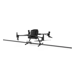
Drone magnetometer - Sensys MagDrone R4
Ultra-portable magnetometer for DJI M300/M350 RTK drones with integrated GPS for surveying large inaccessible areas. Ideal for mineral explo

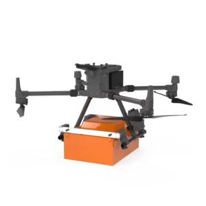
Georadar Drone - Zond Aero 1000 NG GPR
Ultra-lightweight GPR system for geophysical and archaeological surveying on DJI Matrice 300/350. Single unit with Ethernet and WiFi connect
Georadar Drone - Zond Aero 500 NG
Ultralight single-unit GPR for advanced geophysical surveying on DJI Matrice 300/350. Real-time profile visualisation and WiFi/Ethernet conn
Georadar & Magnetometer Combo
Showing all 4 results
-
✓ Pronta consegnaGeoradar, Georadar & Magnetometer Combo, UgCS - SPH
Georadar Drone – Zond Aero 1000 NG GPR
Ultra-lightweight GPR system for geophysical and archaeological surveying on DJI Matrice 300/350. Single unit with Ethernet and WiFi connectivity for real-time analysis. Available at DroneBase, DJI Gold 5 Dealer.
SKU: n/a -
✓ Pronta consegna
-
✓ Pronta consegnaGeoradar & Magnetometer Combo, Magnetometer
Drone magnetometer – Sensys MagDrone R3
Ultra-portable magnetometer with integrated GPS for DJI M300/M350 RTK drones, perfect for surveys across vast inaccessible areas. Ideal for mining exploration, archaeology and security. Available at DroneBase, DJI Gold 5 Dealer.
SKU: n/a -
✓ Pronta consegnaGeoradar & Magnetometer Combo, Magnetometer
Drone magnetometer – Sensys MagDrone R4
Ultra-portable magnetometer for DJI M300/M350 RTK drones with integrated GPS for surveying large inaccessible areas. Ideal for mineral exploration, archaeology and security applications. Available at DroneBase, DJI Gold 5 Dealer.
SKU: n/a
Integrated Geophysical Survey Solutions
Combining georadar and magnetometer technologies on a single platform revolutionizes subsurface investigation capabilities. These integrated systems provide complementary data sets that enhance detection accuracy and reduce survey time. Dual-sensor configurations eliminate the need for multiple flights while delivering comprehensive geophysical data for complex projects.
Archaeological and Heritage Site Documentation
Professional archaeologists rely on combined georadar-magnetometer systems for non-invasive site investigation. The magnetometer detects ferrous artifacts and fired clay structures, while GPR reveals stone foundations, burial chambers, and stratigraphic layers. This multi-modal approach provides complete archaeological site characterization without excavation.
Utility Infrastructure Mapping
Municipal and engineering applications benefit from integrated detection capabilities that identify both metallic and non-metallic utilities. GPR locates plastic pipes, fiber optics, and concrete structures, while magnetometry pinpoints metal pipes, manholes, and buried infrastructure. Combined data processing creates comprehensive utility maps for safe excavation planning.
Advanced processing algorithms correlate GPR and magnetic data to reduce false positives and improve target identification accuracy in urban environments.
Geological and Environmental Surveys
Geological applications leverage the complementary nature of electromagnetic and magnetic sensing for mineral exploration and environmental site assessment. GPR characterizes soil layers and groundwater conditions, while magnetometry maps geological structures and potential contamination sources.
Real-Time Data Integration and Processing
Modern combo systems feature synchronized data acquisition with GPS positioning for precise georeferencing. Real-time visualization allows operators to adjust survey parameters during flight missions. Advanced software suites provide integrated processing workflows that combine GPR and magnetic data for enhanced interpretation capabilities.
Why buy from DroneBase
DJI Gold 5 Partner Status
Exclusive access to enterprise drone platforms with priority support and training programs.
ISO 9001:2015 Quality Assurance
Certified quality management ensures reliable equipment delivery and comprehensive documentation.
Professional Integration Services
Expert payload integration and system configuration for optimal survey performance.
Comprehensive Technical Training
Specialized operator training programs for geophysical survey applications and data processing.
Frequently asked questions
Professional combo systems range from €150,000 to €400,000 depending on sensor specifications, drone platform, and software packages. Contact our specialists for detailed quotations based on your specific survey requirements.
Yes, commercial drone operations require EASA certification and specific authorizations for specialized payloads. We provide guidance on regulatory compliance and can recommend certified training providers for professional operations.
GPR effectively penetrates concrete and asphalt to detect underlying utilities, while magnetometers identify ferrous objects through most surface materials. Detection depth depends on material properties and target characteristics.
Typical survey altitudes range from 3-15 meters above ground level, depending on sensor specifications and target depth. Lower altitudes provide higher resolution but require slower flight speeds for adequate data quality.
Wind speeds above 10 m/s can affect data quality due to platform stability. Rain and high humidity may impact GPR performance. Magnetometer operations are less weather-sensitive but require magnetically quiet conditions.
Systems typically output standard formats including SEG-Y for GPR data, XYZ coordinates for magnetic data, and integrated GIS-compatible formats. Most systems include professional processing software with export capabilities for CAD and mapping applications.
Want a consultation or a demo?
Our DJI Enterprise certified technicians help you choose the right configuration. No commitment.
+39 0541 1790411


