
Drones for Photogrammetry: Advanced Technology for Precision 3D Surveys
Photogrammetry drones offer an advanced solution for performing high-precision three-dimensional surveys, ideal for large areas, complex buildings, and hard-to-reach territories. Using high-resolution cameras mounted on drones, detailed images can be obtained and transformed into accurate 3D models useful for geospatial analysis, topographic surveys, and engineering projects.Why Choose Drones for Photogrammetry?
- Safe and Quick Access: Drones allow inaccessible areas, such as escarpments, ravines and complex structures, to be safely surveyed without risk to personnel.
- Accuracy and Detail: Images captured by drones enable the creation of 3D models with a level of detail critical to survey accuracy.
- Efficiency: With a drone, large areas can be covered in a short time, drastically reducing the time compared to traditional methods.
- Economic Savings: Drones eliminate the need for lifting equipment and reduce operational costs, optimizing time and resources.
Applications of Drones for Photogrammetry
- Construction and Civil Engineering: Creating 3D models of buildings and infrastructure for construction and maintenance projects.
- Topography and Cartography: Topographic surveys to create accurate maps of complex terrain and sites.
- Mining Industry: Monitoring and measuring volumes of extracted materials in quarries and mines.
- Precision Agriculture: Farmland mapping for soil analysis and crop optimization.
- Emergency Management: Monitoring disaster-affected areas for analysis and response planning.
Featured products
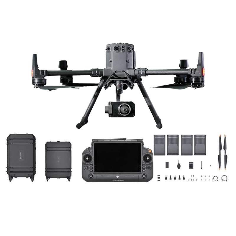
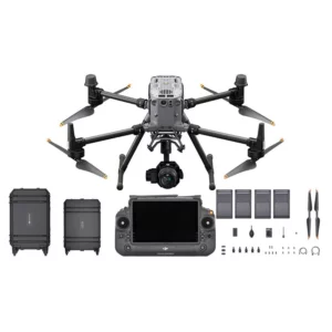
DJI Matrice 350 & BL6100 Pro Photogrammetry Combo
M350 RTK complete bundle with BL6100 Pro camera and BS65 base station: everything for professional photogrammetry with 4 TB65 batteries incl
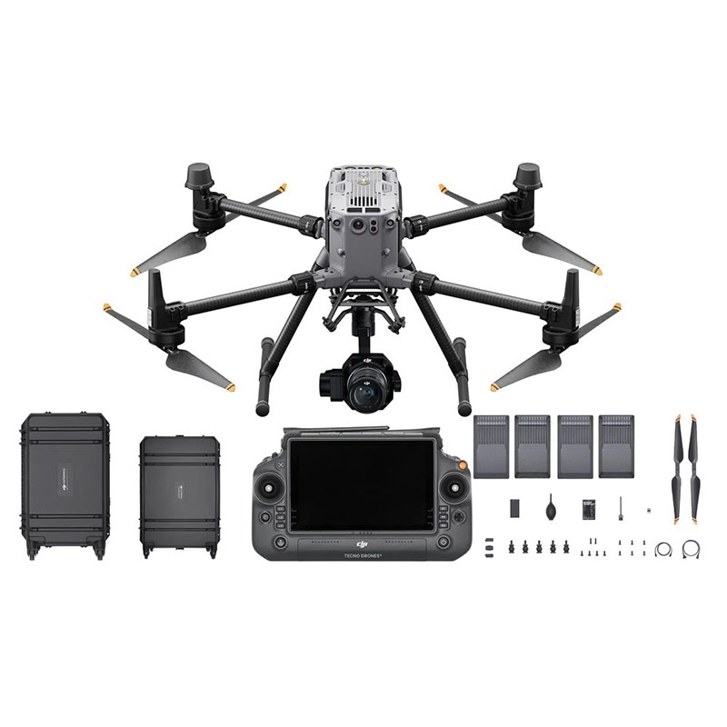
DJI Matrice 350 + Zenmuse P1 Photogrammetry Combo
Complete professional photogrammetry system with M350 RTK and P1 45MP full-frame camera, delivering centimetre-level accuracy and high-resol
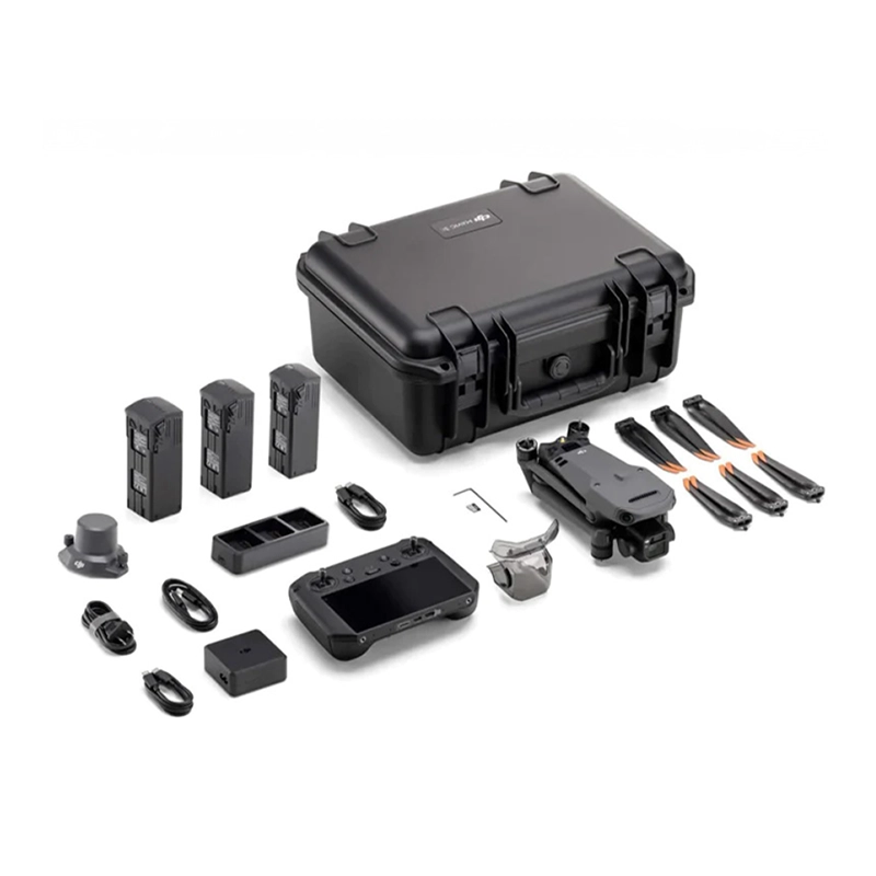
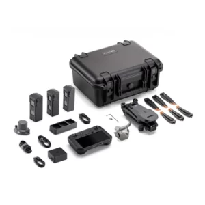
DJI Mavic 3 Enterprise Photogrammetry Combo
Complete photogrammetry kit with Mavic 3 Enterprise, RTK module and additional batteries. Everything for professional precision surveys. Ava
Combo Photogrammetry
Showing all 3 results
-
✓ Pronta consegna
-
✓ Pronta consegnaCombo, Combo Photogrammetry
DJI Matrice 350 + Zenmuse P1 Photogrammetry Combo
Complete professional photogrammetry system with M350 RTK and P1 45MP full-frame camera, delivering centimetre-level accuracy and high-resolution mapping. Includes BS65 charging station and 4 batteries for continuous operations. Available at DroneBase, DJI Gold 5 Dealer.
SKU: DJM351-CP1 -
✓ Pronta consegna
Complete Photogrammetry Workflow Solutions
DroneBase's combo photogrammetry packages integrate cutting-edge DJI enterprise drones with professional-grade cameras and survey software, delivering end-to-end aerial mapping solutions. Each combo includes pre-configured hardware, mission planning software, and processing workflows optimized for surveying, construction monitoring, and volumetric analysis.
Our ISO 9001:2015 certified processes ensure every combo meets stringent quality standards, providing surveyors and engineers with reliable tools for precise data collection and analysis across diverse project requirements.
Advanced Camera Technology for Survey Excellence
The Zenmuse P1 full-frame camera delivers exceptional image quality with its 45-megapixel sensor and mechanical shutter, eliminating rolling shutter distortion critical for accurate photogrammetry. The BL6100 Pro oblique camera system captures nadir and oblique imagery simultaneously, significantly reducing flight times while improving model detail and accuracy.
Both camera systems feature integrated RTK positioning, ensuring centimeter-level accuracy without ground control points in many scenarios, streamlining your survey workflow and reducing field time requirements.
Enterprise-Grade Platform Performance
The DJI Matrice 350 RTK platform provides robust performance with up to 55-minute flight times, enabling coverage of large survey areas in single flights. Its IP55 weather resistance rating allows operations in challenging environmental conditions, while dual-battery hot-swap capability ensures continuous operations for time-critical projects.
For smaller sites and rapid deployment, the Mavic 3 Enterprise offers professional surveying capabilities in a compact form factor, featuring 43-minute flight times and advanced obstacle sensing for safe autonomous missions.
Professional Software Integration
Each photogrammetry combo includes DJI Terra software for mission planning, real-time mapping, and 3D reconstruction processing. The integrated workflow supports various output formats including orthomosaics, digital surface models, point clouds, and 3D models compatible with leading CAD and GIS platforms.
Advanced mission planning features enable automated flight patterns optimized for photogrammetry, ensuring consistent overlap ratios and optimal image quality for accurate reconstruction results across diverse terrain and project types.
Industry Applications and Use Cases
Construction and infrastructure projects benefit from regular progress monitoring, volumetric calculations, and as-built documentation capabilities. Mining operations utilize these combos for stockpile management, pit surveys, and environmental monitoring with high accuracy and efficiency.
Agricultural applications include crop monitoring, yield estimation, and precision agriculture planning, while emergency response teams deploy these systems for rapid situation assessment, damage evaluation, and disaster response coordination across affected areas.
Why buy from DroneBase
DJI Gold 5 Partner Status
Highest level DJI certification ensures access to latest products, technical support, and professional training programs.
ISO 9001:2015 Quality Assurance
Certified quality management systems guarantee consistent service delivery and professional standards throughout Italy.
Complete Solution Packages
Ready-to-deploy combos include hardware, software licenses, and configuration for immediate professional deployment.
Expert Technical Support
Dedicated Italian support team provides local language assistance and rapid response for mission-critical operations.
Frequently asked questions
Each combo includes the drone platform, professional camera payload, batteries, charging hub, remote controller, carrying case, DJI Terra software license, and comprehensive documentation. Some packages also include additional accessories like extra batteries and memory cards.
With RTK positioning, expect 1-3cm horizontal accuracy and 1-5cm vertical accuracy without ground control points. Using ground control points can achieve sub-centimeter accuracy suitable for high-precision surveying and engineering applications.
The Matrice 350 + P1 combo is ideal for large construction sites requiring high accuracy, while the Mavic 3 Enterprise combo suits smaller sites or frequent monitoring due to its portability and quick deployment capabilities.
Yes, commercial drone operations in Italy require ENAC certification and appropriate pilot licenses. Drones over 25kg require additional permits. DroneBase can provide guidance on regulatory requirements and training options.
Standard delivery across Italy is 3-5 business days for in-stock items. Custom configurations or large orders may require 1-2 weeks. Express delivery options are available for urgent project requirements.
Yes, DJI Terra enables real-time 2D reconstruction during flights with the Matrice 350 combos, allowing immediate orthomosaic generation for quick decision-making. Full 3D processing typically requires post-flight processing time depending on area size and detail requirements.
Want a consultation or a demo?
Our DJI Enterprise certified technicians help you choose the right configuration. No commitment.
+39 0541 1790411


