
Sniffer4D Mapper-The Data Visualization and Analytical Software
Gas Analysis and Mapping Software
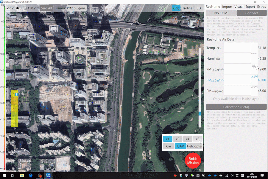
Sniffer4D Mapper visualizes and analyzes Sniffer4D data in real time,
providing intuitive information (e.g., 2D/3D pollution distribution, PDF mission reports) for decision makers.


- Analyze data from Sniffer4D in real time.
- Generates a point cloud heat map of air pollution.
- Supports target setting and navigation.
- View the drone camera view in real time.
- Supports screen recording during missions.
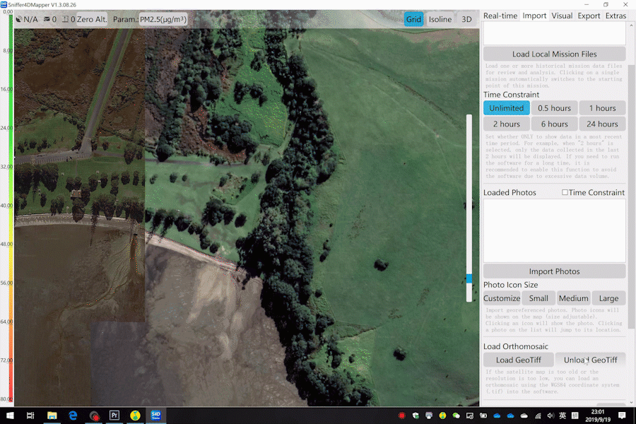
- Upload historical data for analysis and review.
- Load orthophotos (GeoTiff, WGS84) into the software.
- Upload georeferenced photos.
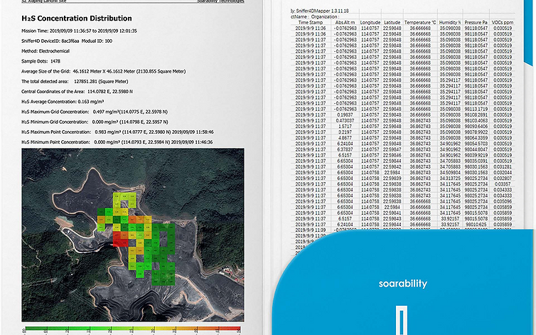
- One-click generation of mission reports (PDF).
- Export mission files as a data sheet (CSV).
- Connections with multiple Sniffer4Ds.
- Three integrated demo missions (drone mounted, car mounted and helicopter mounted).
- It exports decoded Sniffer4D data (json) using MQTT and UDP.
- Automatic software update.
Gas Analysis and Mapping Software
Analyze data from Sniffer4D in real time
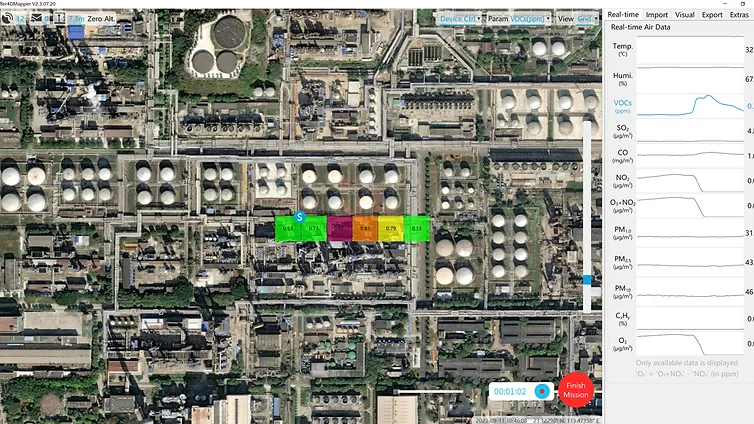
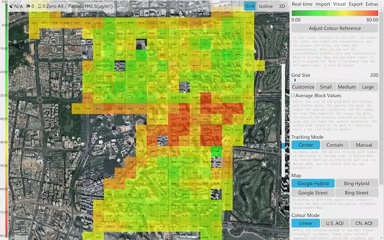
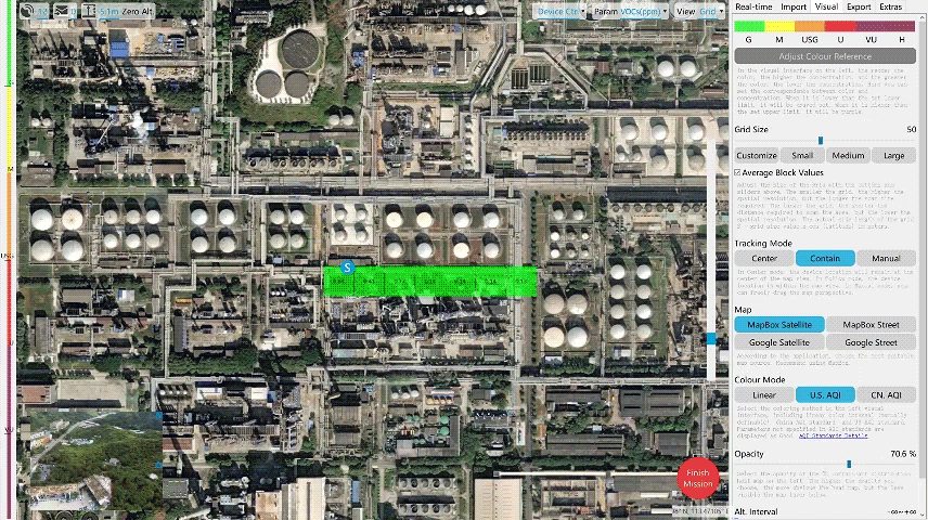
3 Types of Visualization
Generates real-time 2D grid, 2D isoline and 3D point cloud distribution maps of gases and particles, showing at a glance the concentration
and distribution of gases.
Real-Time RGB or Infrared Camera View
Real-time RGB or infrared camera views can be displayed in Sniffer4D Mapper, helping users correlate concentrations and
gas distributions with actual scenes.
Upload past data for analysis and review
Gas Analysis and Mapping Software
Upload Orthophoto (GeoTiff, WGS84) into Software
Users can overlay a high-definition orthophoto on an obsolete or low-definition satellite map to better align high-concentration points with real scenes.

Upload Georeferenced Photos
Users can upload georeferenced photos (e.g., taken with a drone or smartphone) to associate air pollution distribution with corresponding physical photos.

Three Built-in Demo Missions (Drone Mounted, Car and Helicopter)
Users can download Sniffer4D Mapper and use the built-in demo missions for an intuitive experience on how it works the
Sniffer4D system before purchase.
Generating Reports and Data Sheets with a Click
Users can easily export data to MS Excel, Matlab, R and other software for later collection, analysis and interpretation.
Automatic Sending of Data to the Cloud
Sniffer4D supports real-time data output to the specific software platform requested by the user (via the MQTT protocol). In contrast, Sniffer4D Mapper supports output of decoded data (json format) to a designated IP address via UDP.

Sniffer4D Mapper Detailed Specifications
- Displays real-time working status of Sniffer4D, including device name, number of GNSS satellites, relative altitude, and volume of data to be retrieved. Controls Sniffer4D’s high-brightness warning LEDs, gas sampling module, and other features.
- Recovers data not received during a communication breakdown.
- Displays measurement values in real time and their time graphs.
- Generates real-time heat maps for gas concentration/PM in 2D grid.
- Generates real-time heat maps for gas/PM concentrations in 2D isolines.
- Generates real-time heat maps for gas concentration/PM in 3D point cloud.
- View real-time drone camera view and save georeferenced screenshots (“Video Streaming Service” must be selected).
- Estimates Fuel Sulfur Content (FSC) using a proprietary inversion algorithm.
- Supports loading multiple historical data files into the software for later analysis.
- Supports loading an orthophoto (GeoTiff, WGS84) and displaying it under heat maps for concentrations.
- Supports uploading georeferenced photos and displaying their locations in the heat map of concentrations.
- Supports automatic generation of PDF mission reports.
- Supports export of mission files as a CSV data sheet.
- Track and display multiple Sniffer4Ds simultaneously.
- It displays the detailed status of the internal sensing units mounted inside Sniffer4D. The user can calibrate the sensitivity (slope) and zero point (intercept) of each module.
- Exports decoded Sniffer4D data (json) using UDP.
- Unlimited software installations and automatic software updates.
Downloads
Users can download Sniffer4D Mapper and use the built-in demo missions for an intuitive experience of how the Sniffer4D system works before purchase.
Contact us


