
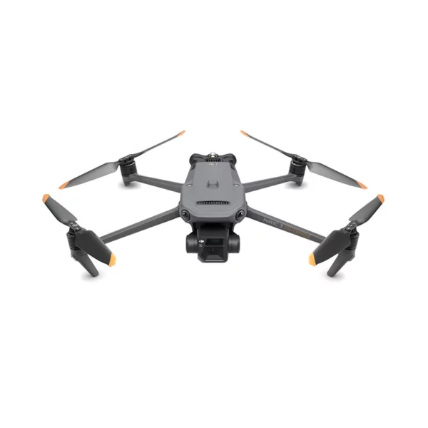
Compact outside.
Enterprise
inside.
The compact commercial drone that redefines the standards of professional mapping. 4/3" CMOS 20 MP sensor with mechanical shutter, 56× hybrid zoom, centimeter-level RTK, and 45 minutes of flight time. Folds into one hand, works like an enterprise platform.
Choose the version
that fits your mission
Same portability, same flight time, two different optical systems. The Mavic 3E is built around precision mapping with a mechanical shutter; the Mavic 3T integrates a radiometric thermal camera for public safety, firefighting, and night inspection operations.
Mapping & Photogrammetry
4/3" CMOS with mechanical shutter and centimeter-level RTK. Designed for surveying, construction sites, industrial inspection, and photogrammetry without Ground Control Points.
- Wide 4/3 CMOS, 20 MP, mechanical shutter f/2.8-f/11
- Tele 12 MP, 162 mm eq., 56× hybrid zoom (28× lossless)
- Rapid shots at 0.7 s intervals, 2 km² mapped in one flight
- Optional RTK module, ±1 cm + 1 ppm horizontal accuracy
- 3.3 μm pixels, dedicated mode for low-light conditions
Thermal & Public Safety
Four optics in one compact gimbal with a 640×512 radiometric thermal camera. Built for firefighting, search and rescue, energy inspection, and night-time public safety operations.
- Wide 1/2" 48 MP, 24 mm equivalent
- Tele 12 MP, 56× hybrid zoom with 14× split-screen
- 640 × 512 thermal camera, spot and area temperature measurement
- Color palettes, isotherms, high-temperature alerts
- Optional RTK, compatible with D-RTK 2 Mobile Station
O3 Enterprise,
4 antennas, 15 km
The four-antenna O3 Enterprise system guarantees stable connections even in complex environments. Real-time 1080p video transmission up to 15 km away, with latency kept to 120 ms. Supports the DJI Cellular Dongle for extended operations in dense urban areas or remote regions.
Want to see if the Mavic 3 Enterprise is the right drone for you?
APAS 5.0,
omnidirectional sensors
Wide-angle lenses on all sides for obstacle avoidance with no blind spots. APAS 5.0 automatically reroutes around obstacles, while the advanced Return-to-Home plans the optimal path to save battery. Integrated AirSense detects nearby manned air traffic.
Omnidirectional
360° obstacles
APAS 5.0
Auto bypass
Advanced RTH
Optimal route
AirSense
Air traffic
The Mavic 3 Enterprise at work,
not on the brochure
Real missions, no renders. If you want a live demo on your actual use case — job site, inspection, topographic survey — we'll arrange a free trial at our Rimini office.
Six tools that
make the difference
Mechanical shutter, integrated RTK, real-time Terrain Follow, Smart Oblique Capture, Corridor mission planning, open SDK. All already on board, ready for professional operations.
Mechanical shutter
The 4/3 CMOS 20 MP sensor eliminates motion blur in moving shots. Rapid 0.7-second intervals for highly efficient photogrammetric surveys without compromising image quality.
56× hybrid zoom
162 mm equivalent telephoto with 28× lossless and 56× hybrid zoom. Observe every detail while maintaining a safe operating distance on pylons, roofs, energy facilities, and critical structures.
RTK module
Centimeter-level accuracy, ±1 cm + 1 ppm. Compatible with standard NTRIP network RTK services and the D-RTK 2 Mobile Station. Topographic surveys without Ground Control Points on the ground.
Terrain Follow
Automatically adjusts altitude when mapping terrain with elevation changes. No external DEM data required, thanks to the integrated omnidirectional sensing on the aircraft.
Smart Oblique Capture
During flight the gimbal automatically rotates in three directions: forward, nadir, and backward. Just two routes cover every angle needed for high-precision 3D modeling.
Open SDK
MSDK, PSDK, and Cloud API to integrate the drone with third-party cloud platforms, develop custom apps, and build proprietary payloads. AES-256 encryption on video transmission.
Where the Mavic 3 Enterprise
becomes a work tool
Eight B2B contexts where the combination of portability, optical quality, and centimeter-level RTK justifies moving away from bulkier platforms without giving up on professional deliverables.
Your use case is on this list. Let's talk.
You're never alone
with your drone
DJI Gold 5 Dealer, ISO 9001:2015 certified. DJI Care Enterprise, original spare parts always in stock, EASA STS training with a specific Mavic 3 Enterprise focus. DJI Enterprise certified technicians.
DJI Care Enterprise
Unlimited repairs within the coverage cap, annual battery replacement, extended fleet coverage.
24h shipping
Delivery across Italy within 24 hours of order. Orders placed before 13:00 CET ship the same day.
Expert support
DJI Enterprise certified technicians, rapid response on-site included. A dedicated account contact for you.
Extended warranty
+1 year on top of the official DJI warranty. Genuine OEM parts and professional engineers.
Training
EASA STS courses plus dedicated operational training on Mavic 3E / 3T, including RTK setup.
Original spare parts
Mavic 3 Enterprise spare parts always in stock. Minimal turnaround times for repairs.
Software and accessories
built for industry
DJI Pilot 2 with refreshed Enterprise interface, FlightHub 2 for cloud fleet management, DJI Terra for 2D/3D processing, DJI Thermal Analysis Tool 3.0 for thermal inspection. Compatible with Pix4D, Agisoft Metashape, and all major photogrammetry suites.
DJI Pilot 2
FlightHub 2
DJI Terra
Thermal Tool 3.0
Cloud API
Let's talk
about your project
We'll help you pick between Mavic 3E and Mavic 3T based on your use case and advise on the best RTK configuration. Free consultation or demo at our Rimini office. Fill out the form below and we'll reply within 48h. Or call us at +39 0541.1790411.
Iper-Ammortamento
+ Nuova Sabatini
Professional drones qualify as eligible Industry 4.0 capital goods. Full cumulability between Iper-Ammortamento and Nuova Sabatini for Italian public bodies, SMEs, and self-employed professionals with a VAT number. Technical 4.0 documentation support included.
Learn moreLease your Mavic 3 Enterprise
Zero down payment · Response within 48h · Available for VAT holders with at least 18 months of business activity · 100% tax deductible on each installment
Request information


