
- Advanced thermal imaging: Accurate detection of temperature changes to identify hidden problems.
- Integration with DJI drones: Full compatibility with DJI platforms, ensuring easy installation and smooth operation.
- Multiple features: Combination of thermography, optical zoom and laser telemetry in one device.
- Industrial inspections: Monitoring electrical infrastructure, buildings, and facilities for overheating or inefficiencies.
- Environmental monitoring: Detection of thermal changes in natural ecosystems for environmental studies.
- Rescue operations: Locating people in low visibility conditions or during night operations.
Featured products

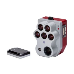
Micasense Altum-Pt.
Multispectral and thermal camera with ultra-high resolution panchromatic imaging for precision agriculture. Dual spatial resolution and CFex

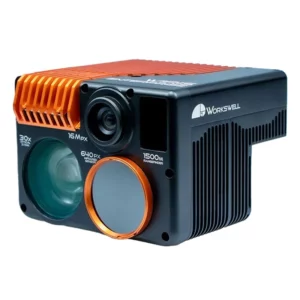
Workswell Wiris Enterprise
Professional thermal camera with 640×512px LWIR sensor and Super Resolution mode for precision inspections. Ultracompact design for maximum

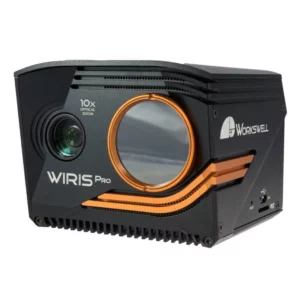
Workswell Wiris Pro
Bispectral LWIR thermal camera 640×512px with Super Resolution for professional radiometric inspections. Compact, precise and efficient for
Thermography with Drones
Showing all 3 results
-
✓ Pronta consegna
-
✓ Pronta consegna
-
✓ Pronta consegnaMultispectral, Sensors for agriculture, Thermography with Drones
Micasense Altum-Pt.
Multispectral and thermal camera with ultra-high resolution panchromatic imaging for precision agriculture. Dual spatial resolution and CFexpress storage for rapid acquisition and efficient data management. Available at DroneBase, DJI Gold 5 Dealer.
SKU: n/a
Industrial Thermal Inspection Applications
Thermography drones revolutionize industrial inspections by providing safe, efficient access to hazardous or hard-to-reach areas. Power line inspections detect hotspots and electrical faults before they cause outages, while solar panel monitoring identifies defective cells and connection issues that reduce energy output.
Building envelope assessments reveal insulation gaps, air leaks, and moisture intrusion with unprecedented detail. Our thermal imaging solutions deliver precise temperature measurements essential for predictive maintenance programs and energy efficiency audits.
Advanced Radiometric Analysis
Professional thermography requires accurate temperature measurement, not just thermal visualization. Our radiometric thermal cameras provide calibrated temperature data with measurement accuracy within ±2°C, enabling quantitative analysis for compliance reporting and trending analysis.
Advanced software tools process thermal data to generate isothermal maps, temperature profiles, and thermal reports that meet international inspection standards for electrical, mechanical, and building diagnostics.
Dual-Sensor Imaging Capabilities
Modern thermography drones integrate multiple imaging sensors to provide comprehensive inspection data. RGB-thermal fusion overlays precise thermal information onto high-resolution visible images, enabling exact localization of thermal anomalies within complex industrial environments.
The Micasense Altum-Pt combines thermal, RGB, and multispectral sensors in one compact payload, delivering vegetation health analysis alongside thermal monitoring for agricultural and environmental applications.
Real-Time Thermal Monitoring
Live thermal video streaming enables immediate decision-making during critical inspections. Real-time temperature measurement allows operators to identify dangerous hotspots, monitor equipment performance, and verify repair effectiveness without interrupting operations.
Professional thermal cameras feature customizable temperature alarms and isothermal overlays that highlight areas exceeding specified temperature thresholds, ensuring no critical thermal anomalies are missed during inspection flights.
Thermal Data Integration Workflows
Effective thermography programs require seamless data integration with existing maintenance management systems. Our thermal imaging solutions export georeferenced thermal data compatible with GIS platforms and CMMS software for asset tracking and trending analysis.
Automated report generation combines thermal images, temperature data, and GPS coordinates into professional inspection reports that support regulatory compliance and insurance documentation requirements.
Why buy from DroneBase
DJI Gold 5 Partner
Authorized enterprise dealer with direct access to professional thermal imaging solutions and technical support.
ISO 9001:2015 Quality
Certified quality management ensures consistent service delivery and product reliability standards.
Professional Training
Comprehensive thermal imaging training programs and ongoing technical support for optimal system utilization.
Italian Service Excellence
Local expertise and rapid response times from our Rimini headquarters throughout Italy.
Frequently asked questions
For building envelope inspections, 320x256 thermal resolution is typically sufficient to detect insulation defects and air leaks. However, 640x512 resolution provides superior detail for precise defect localization and is recommended for commercial building assessments and energy audit compliance.
Thermal drones require standard EASA drone pilot licenses based on aircraft weight and operation type. Additional thermography training is recommended to ensure proper thermal camera operation, radiometric calibration, and accurate temperature measurement techniques for professional inspections.
Professional thermal imaging systems range from €15,000 to €45,000 depending on thermal resolution, radiometric accuracy, and multi-sensor capabilities. Contact our team for detailed quotations including training, software licenses, and support packages tailored to your inspection requirements.
Yes, thermal drones effectively detect electrical hotspots, loose connections, and insulator defects in power transmission systems. Radiometric thermal cameras measure precise temperatures to identify components operating above normal thermal signatures, enabling preventive maintenance before equipment failures occur.
Professional thermal cameras include radiometric analysis software for temperature measurement, thermal data processing, and report generation. Additional software licenses may be required for advanced features like thermal mapping, automated analysis workflows, and integration with existing maintenance management systems.
Professional radiometric thermal cameras achieve measurement accuracy within ±2°C or ±2% of reading when properly calibrated. Accuracy depends on atmospheric conditions, target emissivity settings, and camera calibration status. Regular calibration and proper measurement techniques ensure reliable temperature data for critical applications.
Want a consultation or a demo?
Our DJI Enterprise certified technicians help you choose the right configuration. No commitment.
+39 0541 1790411


