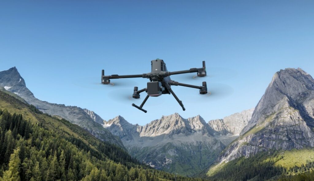
DJI's first long-range, high-precision airborne LiDAR system
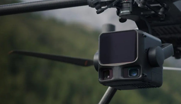
DJI Zenmuse L2
See far and deep, grasp every detail
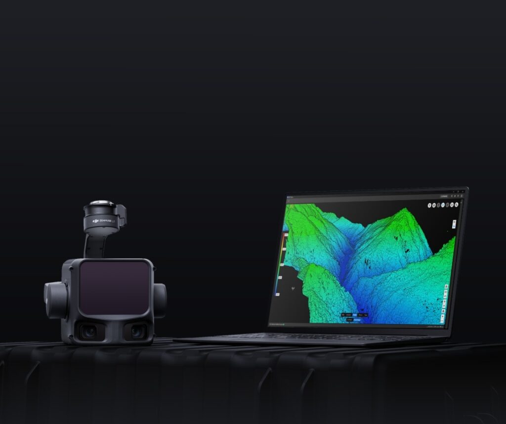
DJI's next-generation high-precision airborne LiDAR system features long-range LiDAR capable of reaching up to 950 m [1] even over objects with 10% reflectivity. Dual 100 MP RGB mapping cameras and a high-precision POS system accelerate geospatial data acquisition, enabling daily coverage of up to 100 km² [2].
1535 nm long-range LiDAR
System of
mapping to
dual
RGB camera
100 MP
Up to 100km2 per day
High Penetration
Up to 100km2 per day
Complete Solution
Redefined Hardware Performance
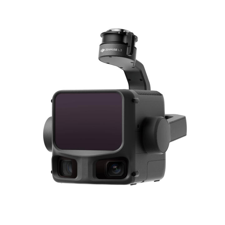
Zenmuse L3 integrates a long-range 1535 nm LiDAR, two 100 MP RGB cameras for mapping, a high-precision POS system, and a three-axis stabilizer, all in a compact device that offers unprecedented performance for its size.
1535 nm long-range LiDAR
Long range, wide coverage
Zenmuse L3 achieves a maximum sensing distance of 950 m [1] at a pulse frequency of 100 kHz, tested under ambient light of 100 klx and on objects with 10% reflectivity. The adjustable pulse frequency allows flexible power delivery and optimal adaptability to different operational scenarios. Typical flight altitudes between 300 and 500 m [3] significantly expand the coverage of a single flight and increase mapping efficiency.
Small laser dot, high energy
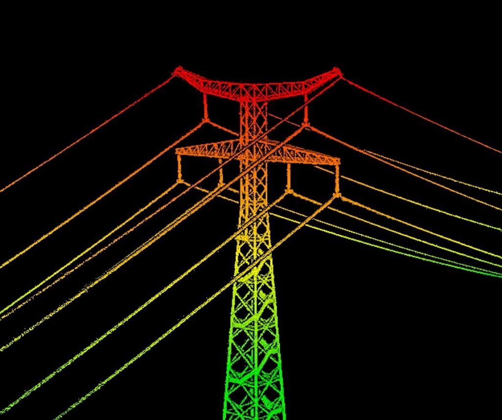
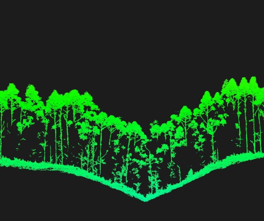
With a laser beam divergence of only 0.25 mrad (1/e²), the spot size at the same distance is about one-fifth that of Zenmuse L2, enabling detection of smaller objects such as power lines and branches. Higher energy density translates into higher penetration capability, significantly increasing the density of ground points under vegetation and enabling high-precision reconstruction of complex terrain and structures.
High pulse frequency, multiple returns
With a maximum laser pulse rate of 2 million pulses per second and support for up to 16 returns [4], Zenmuse L3 offers extremely accurate spatial reconstruction. Point cloud density and penetration capability can be adjusted as needed, from high-accuracy mapping to complex environments.
Scan modes
Supports linear, star, and non-repetitive scanning modes for different operating scenarios: - Linear: provides a more uniform point cloud distribution, ideal for high-precision terrain mapping. - Star: balances accuracy with multiple scanning angles and penetration capabilities, making it ideal for forests or dense urban environments. - Non-repetitive: provides multiple scanning angles and wider coverage, optimized for power line inspection and other complex structural surveys.
100 MP RGB dual camera mapping system
100MP RGB sensor
Equipped with dual 100 MP 4/3 RGB CMOS sensors and a mechanical shutter, Zenmuse L3 offers significantly higher precision and efficiency. Pixel binning supports an effective resolution of 25 MP with a larger pixel size, ensuring superior color reproduction even in low-light conditions.

Ultra-wide-angle FOV of 107°
Two RGB cameras with up to 107° horizontal FOV for wider coverage per shot, even with 20% lateral LiDAR overlap it is possible to capture DOM and DEM in one flight, increasing operational efficiency
Do you have any doubts?
We respond in less than 2 hours, with real technical consultants.
Free first year: DJI Care Enterprise Plus or official extended warranty service

DJI Care Enterprise Plus
Comprehensive protection | Professional quality assurance | Exclusive service | Service starts with activation
Unlimited free repairs
Unlimited free repairs within the coverage limit
Coverage for the entire fleet
Shared coverage for maximum protection
Free two-way shipping
Hassle-free repair with free shipping both ways
Expert support
Quick response from DJI's qualified technicians
Data Security
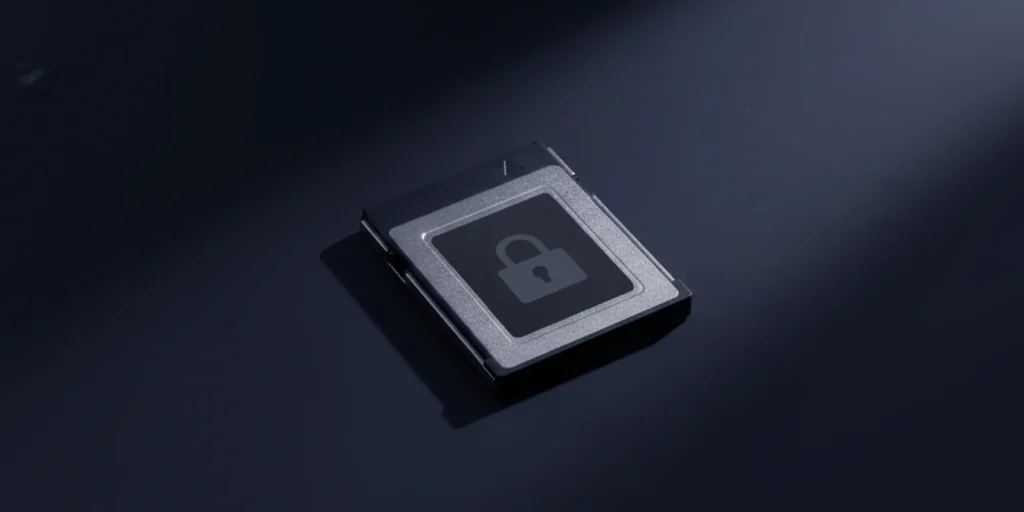
Zenmuse L3 supports CFexpress™ memory card encryption, enabling secure protection of stored data and preventing unauthorized access or data theft. Matrice 400 offers one-click log deletion and AES-256 encryption for video transmission, further ensuring data confidentiality.
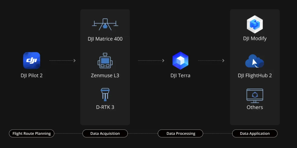
Data acquisition
Estimation of the new of points
Inspection of power lines
Flexible split-screen view
Real-time point cloud
Cloud measurement of point clouds
During operation, DJI Pilot 2 supports three display modes: RGB, point cloud and point cloud/RGB side-by-side display, presenting operational results intuitively. Enabling RNG (Laser Rangefinder) provides access to distance information between the LiDAR module and the object in the center of the FOV, improving flight safety. It also supports four real-time point cloud coloring modes: reflectivity, height, distance and RGB.
After operation, the 3D point cloud model [7] can be viewed directly in the album. The 3D point cloud models of multiple flights can also be merged, allowing on-the-spot decision making regarding operational quality.
After point cloud data is collected, the DJI Pilot 2 app will automatically generate an activity quality report [8] so that operators can check operational results in real time and on site, making field work more responsive and worry-free.
In complex operating environments, users can set RTK base stations before operation to prevent RTK data loss due to interference, video transmission disconnection or other problems beforehand. After operation, it imports the original files into DJI Terra to use the PPK (post-processing kinematics) process to reconstruct high-precision models.
Get efficient and reliable one-stop post-processing when importing point cloud data into DJI Terra. Generate a 3D point cloud model in standard format with one click after point cloud trajectory calculation and accuracy optimization. After classifying the point on the ground using Ground Point Type, a DEM can be generated. The quality of the point cloud can be analyzed with the Accuracy Control and Check function.
Data processing
DJI Terra has robust PPK (Post-Processed Kinematic) capabilities built in, compatible with D-RTK 3 and standard base station data. The platform supports local PPK for RGB and LiDAR imagery, ensuring centimeter-level positioning accuracy even in areas with limited network connectivity or where RTK is not available
DJI Terra enables advanced reconstruction based on Gaussian Splatting fusion of point cloud and RGB data collected by Zenmuse L3, greatly improving the realism and detail of 3D models. This feature expands the scope of LiDAR in different mapping scenarios and provides higher quality 3D model outputs.
DJI Terra enables deep integration of LiDAR and RGB data. With a single acquisition, users can simultaneously generate high-accuracy point clouds, 2D maps, and 3D mesh models. This data fusion approach significantly improves model completeness and detail, especially in environments with complex structures such as bridges and substations. It meets the needs of industries such as energy, transportation and infrastructure.
Data application
DJI Modify supports intelligent semantic classification of point clouds, automatically distinguishing between terrain, vegetation, buildings, wires, power pylons and more. After classification, users can effectively adjust categories using the Quick Selection and Structure Selection tools, further improving classification accuracy and process efficiency.
DJI Modify’s Profile tool allows users to flexibly select cross-sectional areas of point cloud models for intuitive analysis of terrain variations, structural features, and elevation profiles.
Combined with DJI Modify, Zenmuse L3 delivers versatile results. DJI Modify automatically generates a wide range of map products from point cloud data, including semantic point clouds, DEMs, TINs, point grids, and contour lines, and supports multilevel visualization. These outputs meet the diverse needs of workflows related to engineering and CAD design.
1535 nm long-range LiDAR
It provides a complete workflow covering data acquisition, processing and application.
Customers trust Dronebase
We are always available to you.
- Secure Payments
- Quick Deliveries
- Italian Support
Impeccable service and absolute speed. Great!
Andrea
Applicable scenarios
Topographical Surveys
Topographical Surveys
Earthmoving
Geological disaster investigations
Management of sviculture
Electricity
Mining Site Survey
Emergency relief
Haven't found your scenario?
We can analyze together whether this model meets your needs
Request a call: our experts will evaluate your case and propose the most suitable solution.
Call Us Now
for a free consultation on Hardware,
Software and ENAC.
Book Now
your free phone consultation with our Experts.
Up to 40% Tax Relief
The goal of Industry 4.0 and 5.0 is to incentivize Italian companies that invest in capital goods to improve, through digitization, their production processes.
This translates into Fiscal benefits on the one hand and Productive benefits on the other especially for:
- Startup
- Freelancers
- SME
- Public Administration
- Law Enforcement.
Rent your drone from 150€/Month
Pay in convenient installments
– Zero down payment, easy and quick to apply
– All-Risk helmet insurance on drone and accessories
– Small and convenient installments from 24 to 60 months
– Lower costs than a loan or lease
– Asset immediately available
– 100% tax-deductible installment by installment
– Possibility of final redemption of asset
– Possibility of early termination of contract
*Available only for vat holders with at least 18months of activity