
3 km².
In un
volo.
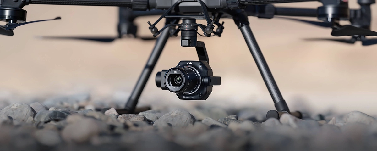
Camera fotogrammetrica full-frame da 45 megapixel con tre obiettivi DJI DL intercambiabili. Otturatore meccanico globale, TimeSync 2.0 a livello di microsecondi, precisione di 3 cm in orizzontale senza Ground Control Points. Per chi misura il territorio dall'alto e ha bisogno di dati metricamente affidabili. Compatibile con Matrice 400, M350 RTK e M300 RTK.
Una camera,
tre focali professionali
Il P1 supporta tre obiettivi DJI DL F2.8 a fuoco fisso, intercambiabili a innesto. Ognuno è ottimizzato per uno scenario specifico — dal grandangolo per coperture estese al telefoto per il dettaglio millimetrico. La 35mm è inclusa nella confezione.
Massima area
Grandangolare per coperture estese e fotogrammetria di area. La scelta per Smart Oblique Capture e mappature topografiche su grandi superfici.
- Campo visivo 84°
- Massima area per scatto
- Ideale per ortofoto 2D
- Perfetto per Smart Oblique
- Mappature catastali estese
L'obiettivo di default
Compromesso ottimale tra area coperta e dettaglio. L'obiettivo standard fornito nella confezione del P1, versatile per la maggior parte dei rilievi.
- Campo visivo 63.5°
- Bilanciamento area/dettaglio
- Versatile su rilievi 2D e 3D
- Incluso nel box di vendita
- Adatto a urbanistica e AEC
Massimo dettaglio
Telefoto per ispezione di precisione e modeling fine. La massima risoluzione per pixel — per soggetti specifici e dettagli architettonici.
- Campo visivo 46.8°
- Massima risoluzione per pixel
- Ispezioni infrastrutturali
- Modeling 3D di facciate
- Beni culturali e archeologia
45 megapixel,
al microsecondo
Sensore CMOS full-frame da 35.9×24mm — il formato dei sistemi fotogrammetrici professionali — con 45 megapixel effettivi e pixel da 4.4 μm per imaging a basso rumore e alta sensibilità. TimeSync 2.0 sincronizza camera, gimbal, controller di volo e modulo RTK al livello del microsecondo, garantendo dati georeferenziati metricamente affidabili. Combinato con la compensazione real-time di posizione e orientamento, raggiunge precisione di 3 cm in orizzontale senza GCP.
Vuoi valutare il P1 per il tuo prossimo progetto?
Una missione
per ogni risultato
Il P1 supporta quattro tipologie di missione native su DJI Pilot 2 — dall'ortofoto 2D di vaste aree al modeling 3D dettagliato di soggetti specifici. La modalità Smart Oblique Capture automatizza la sequenza obliqua con efficienza dal 20 al 50% in più sul post-processing.
Ortomosaico aereo
Mappature topografiche · grandi aree
Generazione di ortofoto georeferenziate ad alta precisione su superfici estese. Acquisizione di scatti planari per costruire mappe 2D continue. Ideale per agricoltura di precisione, catasto, monitoraggio territoriale e ambientale.
Acquisizione obliqua
Modelling di realtà 3D
Acquisizione di immagini oblique multi-angolo per ricostruzione 3D fotorealistica. Sequenza nadir + 4 inclinazioni laterali. Per pianificazione urbana, smart city, modelli digitali del territorio e BIM.
Modeling fine
Soggetti specifici · alta densità
Acquisizione concentrata su singoli soggetti con alta densità di scatti per modelli al centimetro. Ideale per ispezioni di infrastrutture critiche — ponti, dighe, turbine eoliche, monumenti storici, facciate complesse.
Smart Oblique Capture
Efficienza fino al 50%
Il gimbal ruota automaticamente per scattare alle angolazioni necessarie. Ai bordi dell'area scatta solo le foto essenziali — efficienza post-processing dal 20% al 50%. Smart Oblique copre fino a 7,5 km² in giornata lavorativa.
Fotogrammetria aerea
su progetto reale
Il P1 in operativo: rilievo topografico, modeling 3D urbano, ispezione infrastrutturale, documentazione patrimonio culturale. Demo dimostrativa presso la nostra sede di Rimini o sul tuo cantiere/sito di lavoro reale, con processing dei dati su DJI Terra incluso.
Sei tecnologie
che fanno la differenza
Non una semplice camera su gimbal: un sistema fotogrammetrico integrato. Sensore full-frame, otturatore meccanico globale, sincronizzazione di tutti i moduli al microsecondo, gestione dati intelligente, verifica post-volo immediata, ecosistema di sviluppo aperto.
Sensore Full-Frame 45MP
CMOS 35.9×24mm, pixel 4.4 μm, basso rumore e alta sensibilità. ISO 100-12800. La massima qualità d'immagine in formato fotogrammetrico professionale.
Otturatore meccanico globale
Velocità fino a 1/2000s. Esposizione simultanea di tutto il sensore — elimina rolling shutter e distorsione movimento. Impulso di esposizione mediano in microsecondi.
TimeSync 2.0
Sincronizzazione al microsecondo tra camera, gimbal, controller di volo e modulo RTK. Compensazione real-time di posizione e orientamento per dati metricamente affidabili.
DL Mount system
Tre obiettivi DJI DL F2.8 intercambiabili a innesto: 24mm wide, 35mm standard, 50mm detail. Ottiche dedicate ottimizzate per fotogrammetria — non lenti adattate.
Smart Data Management
File auto-associati a missione e timestamp, posizione storage centralizzata per foto, GNSS e file MRK. Metadata completi: parametri intrinseci/estrinseci camera e stato RTK.
Field Work Report
Verifica qualità dati immediatamente dopo il volo: dati di posizione, conteggio immagini acquisite, stato RTK e precisione del posizionamento. Niente sorprese in ufficio.
Otto contesti
dove i numeri contano
Otto ambiti professionali italiani in cui un sistema fotogrammetrico full-frame con precisione centimetrica sostituisce settimane di rilievo a terra. Topografia, catasto, ingegneria civile, urbanistica, geologia, beni culturali, ricostruzione di siti compromessi.
Il tuo settore è tra questi. Parliamone.
Dal rilievo
al deliverable
DJI Gold 5 Dealer certificato ISO 9001:2015. Training avanzato su fotogrammetria, consulenza DJI Terra e workflow di post-processing, integrazione con software CAD/GIS, fornitura MEPA per Pubbliche Amministrazioni, DJI Shield 1 anno incluso.
Training fotogrammetria avanzata
Formazione tecnica su pianificazione missioni, scelta lente, Smart Oblique Capture, calibrazione RTK, gestione GCP opzionali.
Consulenza DJI Terra
Setup e ottimizzazione processing su DJI Terra. Generazione ortofoto, modelli 3D, point cloud, output CAD/GIS-ready.
Spedizione 24h
Consegna in tutta Italia entro 24 ore dall'ordine. Imballaggio professionale per trasporto sicuro di camera e ottiche DL.
Supporto tecnico dedicato
Consulente certificato assegnato all'account. Assistenza pre e post vendita senza limiti di chiamate, copertura sui workflow GIS/CAD.
DJI Shield 1 anno incluso
Garanzia estesa DJI Shield già nella confezione. Estensioni e DJI Care Enterprise disponibili per copertura flotta professionisti.
Integrazione CAD/GIS
Supporto integrazione output P1 con Autodesk, Bentley, ESRI, Agisoft Metashape, Pix4D. Workflow personalizzato per il tuo studio.
Pipeline completa
dall'acquisizione al modello
DJI Pilot 2 per pianificazione missioni e controllo in volo, RC Plus con schermo 7" HD, DJI Terra come motore di processing fotogrammetrico (mesh, point cloud, ortofoto, modelli 3D), DJI Modify per editing modelli 3D, DJI Shield per copertura prodotto inclusa.
DJI Pilot 2
RC Plus
DJI Terra
DJI Modify
DJI Shield
Parliamo
del tuo prossimo rilievo
Ti aiutiamo a valutare il P1 sul tuo workflow specifico: scelta della lente per il tipo di rilievo, integrazione con la tua flotta DJI, tempi e accuratezza attesi sul tuo cantiere tipo, fornitura MEPA per enti pubblici. Demo presso la nostra sede di Rimini o sul tuo sito di lavoro reale. Compila il form e ti ricontattiamo entro 48h. Oppure chiamaci allo 0541.1790411.
Iper Ammortamento
+ Nuova Sabatini
Il Zenmuse P1 rientra nei beni 4.0 agevolabili se abbinato a piattaforma enterprise con requisiti di interconnessione (Matrice 400, M350 RTK, M300 RTK). Cumulabilità tra Iper Ammortamento e Nuova Sabatini fino al 50-60% di recupero complessivo sul sistema integrato drone + payload + software DJI Terra. Documentazione tecnica 4.0 inclusa. Disponibile su MEPA per studi di geometri, ingegneri e Pubbliche Amministrazioni.
Scopri come funzionaNoleggia il tuo Zenmuse P1
Zero anticipi · Risposta entro 48h · Assicurazione casco All-Risk inclusa · Rate da 24 a 60 mesi · 100% deducibile rata per rata · Possibilità di riscatto finale · Disponibile anche su MEPA
Richiedi preventivo personalizzato


