
The most powerful and cost-effective software on the market for advanced LiDAR data processing. Transform point clouds into millimetre-precision 3D models with professional tools for surveying and civil engineering.
| 3-5 cmLiDAR Accuracy | 8 formatsSupported Sensors | GNSS+IMUPost Processing | PPK/RTKSupported Systems |


TOPODRONE software represents the most comprehensive and economical solution for professional LiDAR data post-processing, with native support for DJI and AUTEL systems.
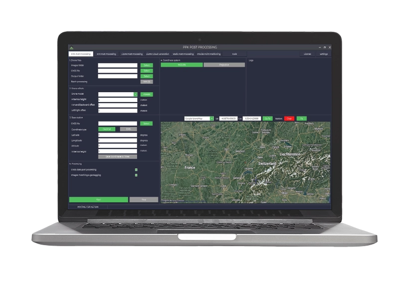
The TOPODRONE LiDAR Post Processing License represents the most advanced and cost-effective software solution for professional LiDAR data processing and GNSS post-processing. Specifically designed to support the complete range of TOPODRONE PPK and LiDAR systems, this software offers native compatibility with DJI Phantom 4 RTK, DJI P1 and AUTEL EVO II PRO RTK, ensuring maximum operational flexibility. The platform integrates advanced modules for high-precision GNSS post-processing, image geotagging, precise trajectory calculation based on GNSS and IMU data, and georeferenced point cloud generation from VELODYNE, LIVOX AVIA and HDL 32 sensors. DroneBase, DJI Gold 5 Dealer certified ISO 9001:2015, provides specialised technical support and training to maximise the performance of this powerful LiDAR data processing tool.
Which LiDAR sensors does the software support?
Is it compatible with DJI drones?
What type of licence is provided?
Can the software process GNSS data in post-processing?
Is it possible to process multiple flights simultaneously?
What technical support is included?
Pre and post-sale assistance · 24h express shipping · Certified technical support · On-site demo
★ DJI Gold 5 DealerISO 9001:2015Technical SupportOn-site Demo


There are no reviews yet.