
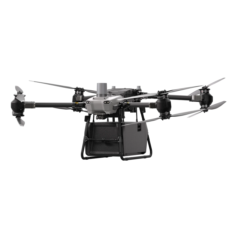
- High load capacity: The DJI FlyCart 30 can carry up to 30 kg, enabling significant loads to be carried over long distances.
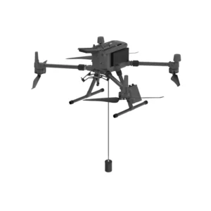
- Flexible delivery modes: Supports two delivery modes: via box or winch, adapting to different operational scenarios.
- Advanced safety: Equipped with a parachute system for emergency landings and an ADS-B receiver that alerts you to the presence of other aircraft nearby.
- Long-range video transmission: DJI O3 technology ensures stable video transmission up to 20 km, with 1080p live feeds.
- Resistance to environmental conditions: Designed to operate in a wide range of temperatures ( -20°C to 45°C) and withstands winds up to 12 m/s, ensuring reliable operations in a variety of weather conditions.
- DJI RC Plus FlyCart: Radio control with 7-inch high-brightness screen for precise and intuitive control of the drone.
- DJI FlyCart 30 Winch System Kit: Winch system kit for delivery operations in areas without suitable landing sites.
- Tethered System DJI FlyCart30 - 240m: System that providescontinuous and stablepower for extended flights, ideal for aerial surveillance and emergency operations.
Featured products
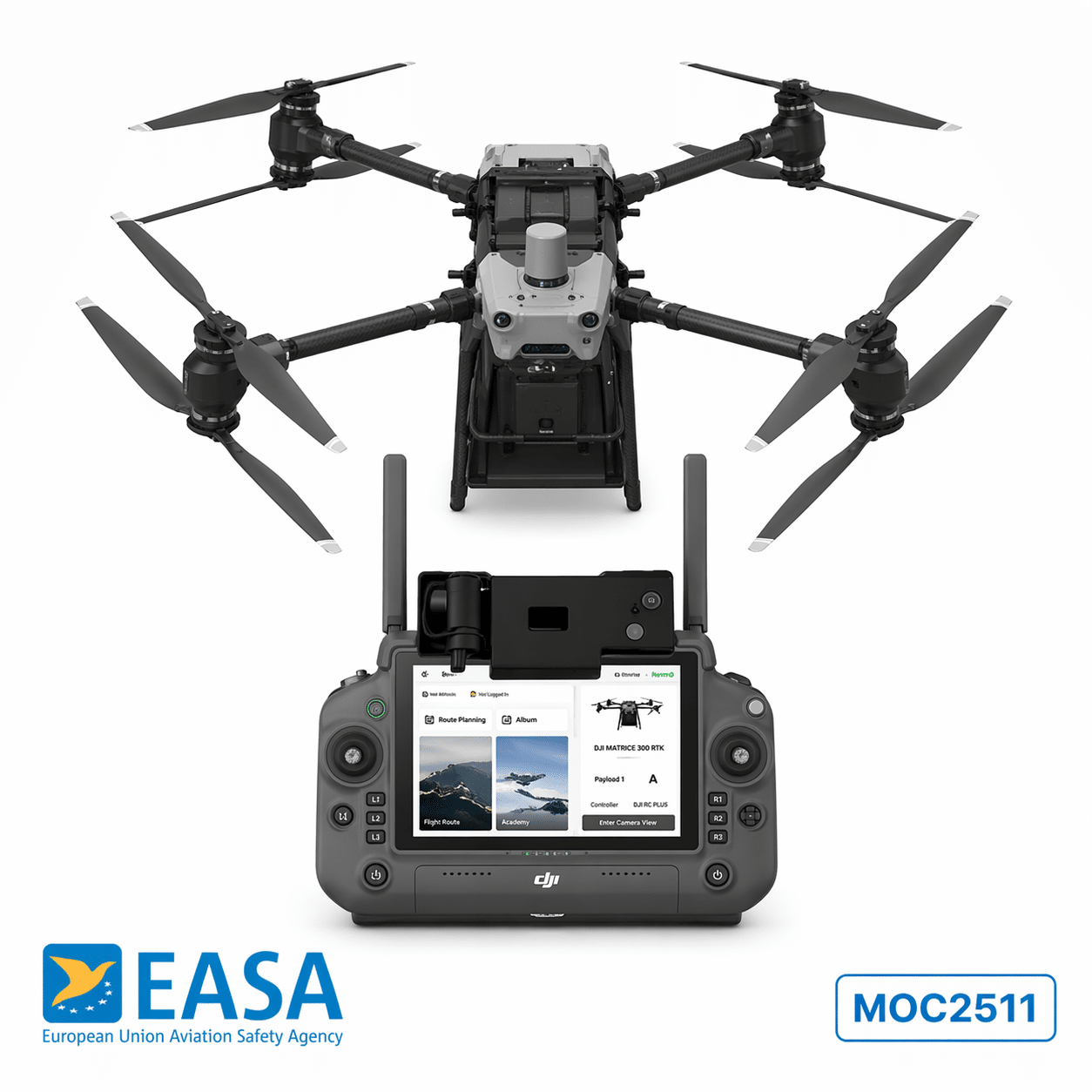
FTS Flight Terminator for DJI Flycart 30
Certified flight terminator MOC2511 with GeoCage for DJI FlyCart 30. Plug-and-play installation with no structural modifications, manual rad
DJI FlyCart 30 (No Warranty)
Cargo drone with payload capacity up to 30 kg and range of 28 km, revolutionises logistics with dual delivery modes via box or winch. Availa

Tethered DJI Flycart 30 - 240m
240m Tethered System with continuous 24H+ power supply for DJI FlyCart 30, IP54 certified for weather resistance. Perfect for video surveill
Drone bathymetry
Showing all 2 results
-
✓ Pronta consegna
-
✓ Pronta consegna
Advanced Underwater Surveying Technology
DroneBase's drone bathymetry solutions combine cutting-edge echosounder technology with professional UAV platforms to deliver unprecedented underwater mapping capabilities. Our EchoLogger systems enable rapid, cost-effective bathymetric surveys across diverse aquatic environments, from shallow coastal waters to deeper inland waterways.
These systems provide real-time depth measurements with exceptional accuracy, making them ideal for hydrographic surveying, marine construction projects, and environmental monitoring applications throughout Italy and beyond.
EchoLogger ECT Series Comparison
The EchoLogger ECT D052S excels in shallow water applications, offering precise depth measurements in coastal zones, harbours, and inland waterways. Its compact design ensures seamless integration with professional DJI drone platforms while maintaining survey-grade accuracy.
For more demanding applications, the EchoLogger ECT 400S delivers enhanced penetration depth and superior signal processing capabilities. This advanced system supports comprehensive bathymetric mapping projects requiring maximum precision and reliability in challenging underwater environments.
Professional Applications and Use Cases
Drone bathymetry systems serve critical roles in marine engineering projects, providing essential depth data for port development, dredging operations, and underwater infrastructure planning. Environmental consultants rely on these systems for habitat mapping, sediment analysis, and water quality assessments.
Research institutions and surveying companies utilise our bathymetric solutions for coastal erosion studies, flood risk assessments, and hydrographic chart updates, significantly reducing survey time while improving data accuracy and safety.
Integration with Professional DJI Platforms
Our EchoLogger bathymetry systems integrate seamlessly with professional DJI drone platforms, leveraging advanced flight control systems and precise positioning capabilities. This integration ensures consistent, repeatable survey patterns essential for accurate bathymetric data collection.
DroneBase provides complete system configuration and calibration services, ensuring optimal performance across diverse survey conditions and environmental challenges faced by Italian marine professionals.
Data Processing and Analysis Capabilities
Advanced data processing software accompanies our bathymetry systems, enabling real-time depth visualisation and post-processing analysis. Users can generate detailed bathymetric charts, cross-sectional profiles, and volumetric calculations essential for engineering and research applications.
The software supports industry-standard data formats, ensuring compatibility with existing GIS workflows and CAD systems used by surveying professionals and marine consultants throughout Italy.
DroneBase Professional Support Services
As an ISO 9001:2015 certified DJI Gold 5 Dealer, DroneBase provides comprehensive support for professional bathymetry operations. Our technical team offers system training, calibration services, and ongoing maintenance support to ensure consistent survey performance.
We provide expert consultation on bathymetry system selection, helping clients choose optimal configurations for specific survey requirements and operational environments across Italian waters.
Why buy from DroneBase
DJI Gold 5 Partner
Certified professional dealer providing expert bathymetry system integration and support.
ISO 9001:2015 Certified
Quality-assured service delivery for critical professional surveying applications.
Technical Expertise
Specialised knowledge in marine surveying and hydrographic data collection systems.
Professional Training
Comprehensive operator training and ongoing technical support for bathymetry systems.
Frequently asked questions
Professional drone bathymetry systems typically achieve depth measurement accuracy within ±10cm, depending on water conditions and system configuration. The EchoLogger series provides survey-grade precision suitable for commercial hydrographic applications.
Professional bathymetry system pricing varies based on specifications and integration requirements. Contact DroneBase for detailed quotations tailored to your specific surveying needs and operational requirements.
EchoLogger bathymetry systems integrate with professional DJI platforms including the Matrice series. DroneBase provides complete system integration ensuring optimal performance and regulatory compliance.
Drone bathymetry operations require appropriate EASA drone pilot certification and may need additional permits for marine surveying activities. DroneBase provides guidance on regulatory requirements for Italian waters.
Measurement range depends on water clarity, bottom composition, and system specifications. EchoLogger systems typically measure depths from 0.5m to 50m+ in optimal conditions, with performance varying based on environmental factors.
Yes, professional bathymetry systems are designed for both freshwater and saltwater operations. Proper maintenance protocols ensure reliable performance in marine environments while protecting equipment from corrosion.
Want a consultation or a demo?
Our DJI Enterprise certified technicians help you choose the right configuration. No commitment.
+39 0541 1790411


