

DJI’s most advanced mapping and 3D modelling software. Integrates Gaussian Splatting, LiDAR reconstruction and professional tools for enterprise projects. Complete solution for photogrammetry, multispectral mapping and industrial applications.
| 30,000 imagesPer project | 500 photos/hourProcessing | 32 GBMinimum RAM | 365 daysAnnual licence |
Generate detailed and realistic 3D models from photographs, preserving reflective surfaces, transparent materials and vegetation with photographic quality.
Combines LiDAR and photogrammetry data for centimetre-precision models. Compatible with Zenmuse L2 and RTK/PPK workflows.
DJI Terra Flagship represents the pinnacle of professional modelling and mapping, integrating the most advanced technologies for large-scale enterprise projects.
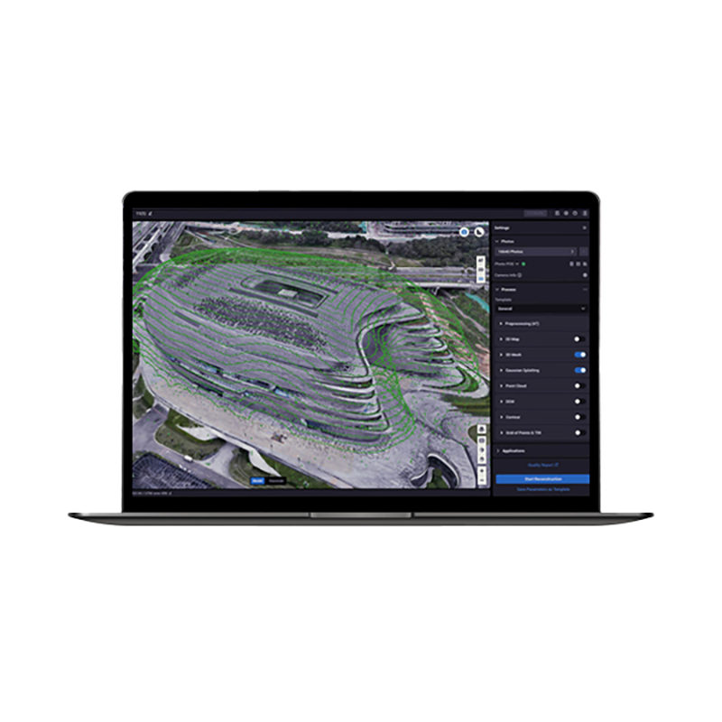
DJI Terra is a 3D modelling software equipped with next-generation reconstruction technologies, including 3D Gaussian Splatting. The Flagship version represents the most complete solution for professionals requiring advanced tools for photogrammetry, LiDAR mapping and multispectral analysis. Integrated with DJI drones such as Matrice 4E/400, Mavic 3 E/T and Zenmuse L2, Terra offers a unified solution for data acquisition and processing with survey-grade precision on entry-level hardware. DroneBase, a DJI Gold 5 Dealer certified ISO 9001:2015, provides specialist technical support and advanced training to maximise the potential of this powerful professional mapping and enterprise 3D modelling software.
What is the difference between Standard and Flagship?
Can I use Terra Flagship without an internet connection?
What hardware do I need to use Terra Flagship?
Is it compatible with non-DJI drones?
Can I upgrade from Standard to Flagship?
How does Gaussian Splatting work?
Pre and post-sale assistance · Express 24-hour shipping · Certified technical support · On-site demos
★ DJI Gold 5 DealerISO 9001:2015Technical SupportOn-site Demo


There are no reviews yet.