
Photogrammetry.
Without limits.
The industry-leading professional photogrammetry software for processing drone, LiDAR and satellite data. Photogrammetric triangulation, dense point clouds, DSM/DTM, georeferenced orthomosaics, textured 3D models, multispectral processing, Python/Java APIs and network processing. From a single workstation to a distributed computing cluster.
From raw data
to final deliverable.
Metashape Professional covers the full photogrammetric workflow: from automatic image triangulation to the generation of dense point clouds, digital elevation models, georeferenced orthomosaics and textured 3D models. Every step is fully configurable to suit any project type and scale.
Photogrammetric triangulation
Processing of aerial (nadir, oblique), close-up and satellite images. Auto-calibration for frame cameras (including fisheye), spherical and cylindrical cameras. Multi-camera project support and scanned images with reference marks.
Dense point cloud
Advanced model modification for accurate results. Automatic multi-class point classification customizable for further reconstruction. Full import/export support for integration into the classic point data processing workflow.
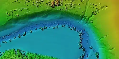
DSM / DTM
Digital Surface Model and/or Digital Terrain Model depending on the project. Georeferencing from EXIF metadata/flight log and GCP data. EPSG coordinate system support: WGS84, UTM and more. Configurable geoid grid and advanced editing with break line drawing and fill tools.
Georeferenced orthomosaics
GeoTIFF compatible with most GIS software and KML for Google Earth. Block export for large projects. Color correction for homogeneous textures. Built-in ghosting filter to combat artifacts from moving objects. Custom planar and cylindrical projection for close-range projects.
Textured 3D models
Reconstruction of archaeological sites, artifacts, buildings, interiors, people and more. Direct upload to online platforms and export to many popular formats. Photorealistic textures with HDR and multifile support including UDIM layout.
GCPs & scale bars
GCP import for georeferencing and accuracy verification. Automatic detection of coded/uncoded targets for rapid GCP input. Scale bar tool to set reference distance without positioning equipment.
Looking for the most complete photogrammetry software for drone and LiDAR data?
LiDAR, multispectral,
4D, APIs & network.
Metashape Professional includes advanced features that set it apart from consumer photogrammetry software: native LiDAR support, multispectral processing with NDVI, 4D modeling for dynamic scenes, automatic power line detection, cloud and distributed network processing, and Python/Java APIs for full pipeline automation.
LiDAR support
Aerial LiDAR point cloud attribute support. External registration for laser scans. Marker-based alignment of laser scans. Display laser scans in the Model view. Ground point classification adapted for LiDAR data.
Multispectral processing
RGB/NIR/thermal/multispectral image processing. Fast reconstruction based on the preferred channel. Multi-channel orthomosaic generation and calculation and export of user-defined vegetation indices (e.g. NDVI).
Built-in measurements
Built-in tools for measuring distances, areas and volumes. For more sophisticated metric analysis, photogrammetric products can be seamlessly transferred to external tools using a variety of export formats.
Stereoscopic measurements
Professional 3D monitor and 3D controller support for accurate and convenient stereoscopic vectorization of measurement features. Ideal for high-precision survey applications.
Hierarchical tiled models
City-scale modeling preserving the original image resolution for texturing. Cesium publication for web-based 3D visualization of large urban and territorial datasets.
4D modeling
Multi-camera rig data processing for creative projects in film and video game production. 3D models reconstructed in time sequence as the basis for numerous visual effects.
Panoramic stitching
3D reconstruction from data acquired at the same camera location (minimum 2 stations). 360° panoramic stitching from a single camera station. For immersive documentation and virtual tours.
Power line detection
Automatic power line detection on large-scale projects: requires only aligned images as input. Results exported as a 3D polyline model for each wire. Reliable results thanks to the catenary curve fitting algorithm.
Satellite image processing
Common processing workflow for panchromatic and multispectral satellite images with sufficiently accurate RPC data. Support for major commercial satellite imagery providers.
Python & Java APIs.
Network or cloud.
Metashape Professional is not just a desktop application — it is an automatable and scalable platform. The Python and Java APIs allow you to integrate Metashape into any processing pipeline: from automatic batch processing and adding custom operations to the GUI, to full workflow automation in Python or Java environments. For large datasets, network processing distributes computations across a local network of nodes to harness the combined power of multiple machines on a single project. Cloud processing eliminates the need for local hardware infrastructure, with the added option to view and share results online with colleagues or clients and embed published projects into your own web platforms.
From drone survey
to 4D cinema.
Metashape Professional is adopted across vastly different industries — because quality photogrammetry is a universal need. Topographic survey, archaeology, infrastructure inspection, precision agriculture, urban digital twin, cinema and VFX, scientific research. One software, endless applications.
Ready to process your drone data with the most complete photogrammetry software?
Licensing, training &
pipeline integration.
DJI Gold 5 Dealer certified ISO 9001:2015. Metashape integrates seamlessly into the DJI workflow: data acquisition with Matrice + Zenmuse P1/L2, mission planning with UgCS, processing with Metashape. We support you from license selection to full operational readiness on your first real project.
License consulting
Metashape is available in Standard and Professional editions. We help you choose: if you need GCP, LiDAR, multispectral, Python/Java APIs or network processing, the Pro version is essential. We analyse your scenario and recommend the optimal configuration.
Photogrammetry training
Hands-on training on Metashape Pro: triangulation, dense point cloud, DSM/DTM, orthomosaic, 3D models, GCP, multispectral NDVI processing. In-person training at our Rimini office or remote webinar using your own real drone dataset.
DJI pipeline integration
Full workflow setup UgCS → DJI Terra/Pilot 2 → Metashape: optimal flight planning for photogrammetry, data acquisition with Zenmuse P1, processing in Metashape with GCPs and GeoTIFF/LAS output. The end-to-end pipeline for professional surveys.
Python automation
Development of custom Python scripts to automate the Metashape workflow: multi-project batch processing, automatic export in multiple formats, integration into existing GIS/BIM pipelines. Significant time savings on serial processing tasks.
Recommended hardware
Workstations optimised for Metashape Pro: NVIDIA GPU with high VRAM for dense cloud and mesh processing, multi-core CPU for triangulation, large RAM for big projects, NVMe SSD for fast I/O. Custom hardware configuration based on your project type and volume.
Ongoing technical support
Dedicated consultant for your account. Support on complex processing jobs, parameter optimisation for different scenarios (LiDAR, multispectral, satellite), troubleshooting, software updates and migration from other platforms (Pix4D, DroneDeploy, OpenDroneMap).
Metashape in the complete
DJI Enterprise workflow
Metashape Professional fits as the photogrammetric processing engine in the DJI Enterprise workflow: plan flights in UgCS, acquire data with Matrice 400 + Zenmuse P1 (photogrammetry) or L2/L3 (LiDAR), process in Metashape with GCPs and obtain certified DSM, orthomosaics and point clouds. A powerful alternative to DJI Terra for those who need maximum processing flexibility and automation.
UgCS Flight Planning
Matrice 400 · Zenmuse P1/L2
Metashape Processing
DJI Modify · Cleanup
GIS · BIM · CAD Export
Transition Plan 5.0
+ Nuova Sabatini
Metashape Professional, combined with DJI Enterprise drones and photogrammetric/LiDAR payloads, qualifies for the Italian Transition Plan 5.0 and Nuova Sabatini incentives: software-driven workflows with certified digital outputs, integration with corporate BIM/GIS systems, pipeline automation via API. Technical documentation included. Available on MEPA for Public Administrations, cultural heritage authorities, universities and research institutions.
Learn about incentivesAgisoft Metashape Pro — Buy in the Shop
The Professional edition includes everything: photogrammetric triangulation, dense point cloud, DSM/DTM, GeoTIFF orthomosaics, textured 3D models, LiDAR support, multispectral NDVI processing, GCPs, 3D measurements, hierarchical tiled models for Cesium, 4D modeling, power line detection, satellite image processing, Python/Java APIs, network processing and cloud processing. Purchase directly from the DroneBase shop — DJI Gold 5 Dealer certified ISO 9001:2015.
Buy Metashape Pro 📞 0541.1790411


