Magnetometer

SENSYS MAGNETO® Desktop | Magnetic Data Analysis Software

The SENSYS MAGNETO® Desktop is the professional SENSYS GmbH software for the comprehensive analysis of magnetic and electromagnetic data from area and borehole surveys. Automatic calculation of position and size of suspicious objects, color-coded maps, multi-dataset management, integrated text editor for reporting. Standard for UXO, archaeology, geophysics and offshore investigations. Compatible with the entire SENSYS ecosystem (MagDrone, MagWalk, MX, BM2). DroneBase is official reseller.

sensys magneto software magnetometer dji matrice
SENSYS MAGNETO is a software for the comprehensive analysis and interpretation of measurement data from magnetic and electromagnetic area and borehole surveys.
5.410,00  TAX (22%) Included
Invoicing available at check-out
Yours from 119,64 €/month with Grenke Operating Lease
🌍 VAT-FREE
Tax-Free Shopping For EU businesses registered in VIES
Talk to an expert Dedicated technical consultant — Mon–Fri 9:00 AM–6:00 PM
Call
Register now → ACCESS DISCOUNTS
Register now and get exclusive discounts on all products. Reserved prices are visible only to registered users.
Access the Reserved Pricing
We recommend

Add to your order

Products hand-picked by our engineers. Select and add them to your cart in one step.

Drone for archaeology - magnetometer
Drone magnetometer - Sensys MagDrone R3 - Combo Kit with Drone
41.480,00  TAX (22%) Included
TAX Included
View product →
Drone for archaeology - magnetometer
Drone magnetometer - Sensys MagDrone R3 - Standard Magnetometer Kit
19.520,00  TAX (22%) Included
TAX Included
View product →
Drone for archaeology - magnetometer
Drone magnetometer - Sensys MagDrone R4 - Combo Kit with Drone
69.540,00  TAX (22%) Included
TAX Included
View product →
Drone for archaeology - magnetometer
Drone magnetometer - Sensys MagDrone R4 - Standard Magnetometer Kit
47.580,00  TAX (22%) Included
TAX Included
View product →
Aggiunto al carrello!
Professional analysis software · DroneBaseSENSYS MAGNETO® — Desktop Magnetic Data Analysis Software

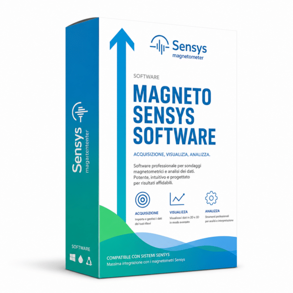
Professional SENSYS MAGNETO® software in the desktop version, dedicated to the comprehensive analysis and interpretation of magnetic and electromagnetic area and borehole survey data. Automatic calculation of position and size of suspicious objects, color-coded maps, multi-session management and integrated reporting. Industry standard for UXO detection, archaeology, geophysics and offshore surveys. Distributed by DroneBase, official SENSYS reseller.

4+Application SectorsMultiDataset Layers2D/3DMap VisualizationProSoftware Level
SENSYS MAGNETO Desktop Software
Magnetic map analysis with MAGNETO
From acquisition to reportThe reference software for magnetic data interpretation

MAGNETO® is the standard desktop platform for the complete management of magnetic survey workflows: data import from area and borehole systems, color-coded maps, line tracking, overlay of multiple sessions, automatic identification of suspicious objects and generation of professional technical reports.

Why choose itKey advantages

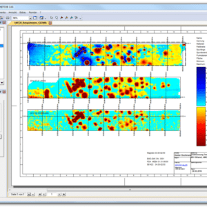
SENSYS MAGNETO® Desktop is the reference professional software for those operating in UXO detection, archaeology, geophysics and offshore surveys with magnetometric and electromagnetic instrumentation. It combines advanced calculation algorithms for automatic object localization, color-coded cartographic visualization, multi-dataset management on a single workspace and integrated reporting functions.

Automatic suspicious object calculationProprietary SENSYS algorithms for automatic estimation of position, depth and size of magnetic anomalies
Color-coded maps and trackingColor-coded cartographic visualization of all measurement data with flight tracks and survey lines
Free and modular workspaceMaps, lines, texts, objects, images and frames freely organizable on the workspace for tailored analysis
Multiple datasets in single projectLink datasets from multiple surveys and sessions on the same field in a unified workspace for continuous analysis
Text editor and integrated reportingNative text editor functions for drafting technical reports and client deliverable documentation
Complete SENSYS ecosystemNative compatibility with all SENSYS survey systems: MagDrone, MagWalk, MX series, ARCH I and borehole magnetometers
The productSENSYS MAGNETO®: the reference software for professional magnetic surveys

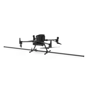
SENSYS MAGNETO® is the professional SENSYS GmbH software dedicated to the comprehensive analysis and interpretation of data collected through magnetic and electromagnetic surveys, both area and borehole. The desktop version is designed for full dataset processing in the office: import, processing, visualization and generation of professional technical outputs. MAGNETO® enables the automatic calculation of position and size of suspicious objects detected in surveys, through proprietary SENSYS algorithms validated in thousands of campaigns worldwide. All measurement data can be visualized in color-coded maps, survey lines or flight tracks, with the ability to freely arrange maps, texts, objects, images and frames on the workspace. The software supports linking multiple datasets from different surveys in a single project, allowing work on an area across multiple sessions and time-based comparison. Integrated text editor functions facilitate technical report drafting and project documentation. MAGNETO® is the standard choice for processing data from surveys on contaminated sites, UXO detection, archaeological and geophysical prospections. The software is compatible with the entire SENSYS ecosystem of magnetometers and gradiometers for aerial surveys (MagDrone R1/R3/R4), pedestrian (MagWalk, ARCH I, SBL10), vehicle (MX V3/V4, SMD12), borehole (BM2, FGM650) and marine (MX3D UW, MMVA). Distributed by DroneBase, official SENSYS reseller and DJI Gold 5 Dealer ISO 9001:2015 certified, with pre and post-sales technical support, MAGNETO® training and specialized consulting for UXO and magnetic survey projects.

FeaturesSoftware features
PROCESSING AND ANALYSIS
Software typeDesktop for office (Windows)
Data types handledMagnetic and electromagnetic
Survey typesArea (surface) and borehole
Object localizationAutomatic position and size calculation
Sensor technologyElectromagnetic, magnetometric, gradiometric
VISUALIZATION AND WORKSPACE
MapsColor-coded for measurement data
Line visualizationSurvey tracks and flight profiles
WorkspaceFree, with maps, texts, objects, images, frames
Multi-datasetLinking of multiple surveys and sessions
Multi-temporal comparisonTime-based comparison of surveys on the same site
REPORTING AND DOCUMENTATION
Text editorIntegrated for report drafting
Documentary outputMaps + text + images in a single document
ExportStandard formats for client delivery
SUPPORTED APPLICATIONS
UXO detectionUnexploded ordnance detection
ArchaeologyArchaeological prospections and heritage sites
Geophysics and geologyGeophysical surveys and geological modeling
OffshoreMarine surveys, pre-installation investigations
Special applicationsContaminated sites, environmental surveys, security
SENSYS ECOSYSTEM COMPATIBILITY
Aerial systems (drone)SENSYS MagDrone R1, R3, R4
Pedestrian systemsSENSYS MagWalk, ARCH I, SBL10
Vehicle systemsSENSYS MX V3, MX V4, MX heavy duty, SMD12
Borehole systemsSENSYS MAGNETO® BM2, FGM650, DBL15, MagCone
Marine systemsSENSYS MX3D UW, MMVA, SEARACK
Who it’s forApplication sectors
UXO detection and deminingUnexploded ordnance detection in construction sites, demolitions and site clearance projects
ArchaeologyArchaeological prospections, search for buried sites, excavation documentation and preventive investigations
Geophysics and geologyGeophysical investigations for geological studies, subsurface structural mapping and mineral exploration
Offshore investigationsMarine surveys for pipelines, offshore wind farms, pre-installation investigations and marine UXO
Law enforcement and securitySearch for buried metallic objects, forensic investigations, support for police and customs operations
Contaminated sites and environmentSurveys on illegal landfills, buried drums, underground infrastructure and environmental remediation
FAQFrequently asked questions
What’s the difference between desktop and mobile versions of MAGNETO®?
The desktop version of MAGNETO® is intended for complete data processing in the office: import, processing, visualization, interpretation and reporting. The mobile version is instead installed on rugged PDAs and supports survey activity directly in the field, with real-time display of data and tracks. This product is the desktop version.
What hardware does the software run on?
SENSYS MAGNETO® Desktop is software for Windows desktop or workstation systems. For updated system requirements and supported operating systems, refer to the official SENSYS datasheet or contact DroneBase for personalized consulting.
Which survey instruments is it compatible with?
MAGNETO® is natively compatible with the entire SENSYS ecosystem: MagDrone R1/R3/R4 aerial magnetometers, MagWalk and ARCH I pedestrian systems, MX V3/V4 and SMD12 vehicle systems, BM2 and FGM650 borehole systems, and MX3D UW and MMVA marine systems.
What does it allow to calculate automatically?
The software allows automatic calculation of position and size of suspicious objects detected in magnetic data. The proprietary SENSYS algorithms are validated in thousands of UXO, archaeological and geophysical campaigns.
Can surveys from different sessions be combined?
Yes, MAGNETO® supports linking multiple datasets from different surveys on the same workspace, allowing continuous work on an area across multiple sessions and time-based comparison of data for multi-temporal analysis.
Does it include reporting functions?
Yes, the software integrates native text editor functions that facilitate the drafting of technical reports and client deliverable documentation, combining maps, text, objects and images in a single output.
Is training provided upon purchase?
DroneBase, as official SENSYS reseller, offers dedicated training on the use of MAGNETO® and technical consulting for the integration of the software into client processes. Contact our team for details on training programs and operational support.
What support does DroneBase offer?
DroneBase provides pre and post-sales technical support, license activation, operational training, consulting for the design of UXO, archaeological, geophysical and offshore campaigns, plus integration of MAGNETO® with SENSYS and DJI survey systems.
SENSYS MAGNETO® Desktop — Available at DroneBase

Professional magnetic analysis software · Automatic suspicious object calculation · Color-coded maps · Integrated reporting · DroneBase training included

★ Official SENSYS ResellerDJI Gold 5 DealerISO 9001:2015UXO · Archaeology · Geophysics

Based on 0 reviews

0.0 overall
0
0
0
0
0

Be the first to review “SENSYS MAGNETO® Desktop | Magnetic Data Analysis Software”

There are no reviews yet.

Why DroneBase

The partner that neverleaves you grounded.

01 — Warranty
Official DJI Warranty
12-month full warranty on original product. Certified purchase from a DJI Gold 5 dealer.
02 — Logistics
24h Express Shipping
Orders placed by 1:00 PM ship the same day. Trackable throughout Italy. Professional packaging.
03 — Support
Dedicated Technical Support
Certified consultant assigned to your account. Unlimited pre- and post-sales support.
04 — Purchase
Free 14-Day Returns
Satisfied or refunded within 14 days of delivery. No-questions-asked policy, full refund.
Tax Incentives 2026

Buy professional drones.Recover up to 60% of your investment.

In 2026, stackable tax tools are active that significantly reduce the effective cost. Available for companies, self-employed professionals and public administration.

01 — Transition 4.0 Plan
Hyper Depreciation
Enhanced tax deduction for technologically advanced capital goods. Directly reduces the IRES/IRPEF taxable base.
+180% deduction up to €2.5M
Learn how it works →
02 — Italian Law Decree 69/2013
Nuova Sabatini
Non-repayable interest contribution on financing or leasing. Reduces credit costs to nearly zero.
Non-repayable grant Active until 2029
Check requirements →
03 — Stackability
Stackable Savings
The two instruments operate on separate levels and can be combined. On a €20,000 enterprise system you can recover up to €10,000–12,000.
50–60% recovery Stackable 2026
Request a simulation →
Technical 4.0 documentation support included. DroneBase assists you with the technical appraisal and interconnection requirements needed to access Hyper Depreciation.
Tax incentive details →
Grenke Leasing
Choose the GrenkeOperating Lease!
  1. 1Add the product to your cart
  2. 2Select Operating Lease as the purchase method
  3. 3Select the monthly payment based on your preferred term (24–60 months)
  4. 4Submit your non-binding request
  5. 5Response within 48h
Discover why leasing makes sense →

Questions about this product?

Fill out the form and one of our experts will get back to you shortly.

Contact Us Now!

Request a free consultation or a demo at our office!
Fill out the form below and our experts will contact you.

Or Call Us Now: 0541.1790411

Field is required!
Field is required!
First Name*
Field is required!
Field is required!
Last Name*
Field is required!
Field is required!
Email*
Field is required!
Field is required!
Phone*
Field is required!
Field is required!
City*
Field is required!
Field is required!
Country
Field is required!
Field is required!
Company / Organization*
Field is required!
Field is required!
VAT / Tax ID*
Field is required!
Field is required!
Insert Your note here*
Field is required!
Field is required!

All fields marked with * are mandatory

Field is required!
Field is required!
Field is required!
Field is required!