Forests Watched by Autonomous Drones
DJI Dock 3 + FlytBase Enterprise + Silvanet sensors — the autonomous ecosystem that protects up to 70 km² of territory with a single station. Scheduled 24/7 AI patrols, real-time thermal verification, response orchestrated from a remote operations center. Zero personnel on site.
When the air and the ground work together
Fixed cameras have blind spots. Human patrols are costly and intermittent. Satellites arrive with hours of delay. By the time a wildfire is visible to the naked eye, it's already too late: it has already doubled in size 30 times in the first 15 minutes.
The DroneBase Autonomous Surveillance system integrates two complementary technologies through the FlytBase Enterprise cloud platform: the DJI Dock 3 with thermal patrol drone and the Silvanet network of IoT sensors that detect pyrolysis gases before any flame appears. Together they form an autonomous system capable of protecting up to 70 km² with a single drone station.
Sensors "smell" the fire in the slow-combustion phase. The drone "sees" the hotspot with its radiometric thermal camera. Cloud AI orchestrates the response. Firefighters arrive within the Golden Hour, while the fire can still be tamed with limited resources.
A complete solution to protect communities
The DroneBase + Silvanet + FlytBase ecosystem helps regions, provinces, municipalities, mountain communities, parks and civil-protection authorities proactively shield citizens, infrastructure and natural heritage from the devastating effects of wildfires. Six direct benefits, four structural qualities of the system.
Rapid Alerts
The system detects the fire within minutes of pyrolysis and immediately deploys the drone for thermal verification. Authorities can act before flames spread, protecting forests, wildlife and people.
Greater Operational Efficiency
Automated 24/7 monitoring of vast forest areas. Drastically reduces the need for costly manual patrols and the exposure of personnel to night shifts in rugged terrain.
Cost Savings
Preventing large-scale fires means saving millions of euros in extinguishing operations, aerial assets, remediation and environmental restoration. ROI is measurable from the very first fire avoided.
Climate Adaptation
By helping to prevent and manage fire outbreaks, the system contributes to a more climate-resilient future, reducing the catastrophic CO₂ emissions tied to major wildfires.
Habitat Conservation
Early fire detection saves millions of animals from perishing and protects countless vital natural habitats, from Natura 2000 sites to national and regional protected areas.
Reduced Maintenance
Solar-powered sensors last 10-15 years with no maintenance and no batteries. Firmware updates are installed over the air. Set up once, operational for over a decade.
Simple
Distributed scalable architecture supporting millions of low-cost sensors.
Efficient
Overcomes the power and connectivity constraints typical of remote forests.
High-Performance
Capable of detecting wildfires before they erupt into visible flames.
Decisive
No assistance required for at least 15 years after sensor installation.

DJI Dock 3 + FlytBase Enterprise
The most advanced drone-in-a-box system on the market. Industrial hardware for extreme environments, natively integrated with the FlytBase Enterprise cloud platform. From alarm to drone in flight in under 60 seconds, with zero personnel on site.
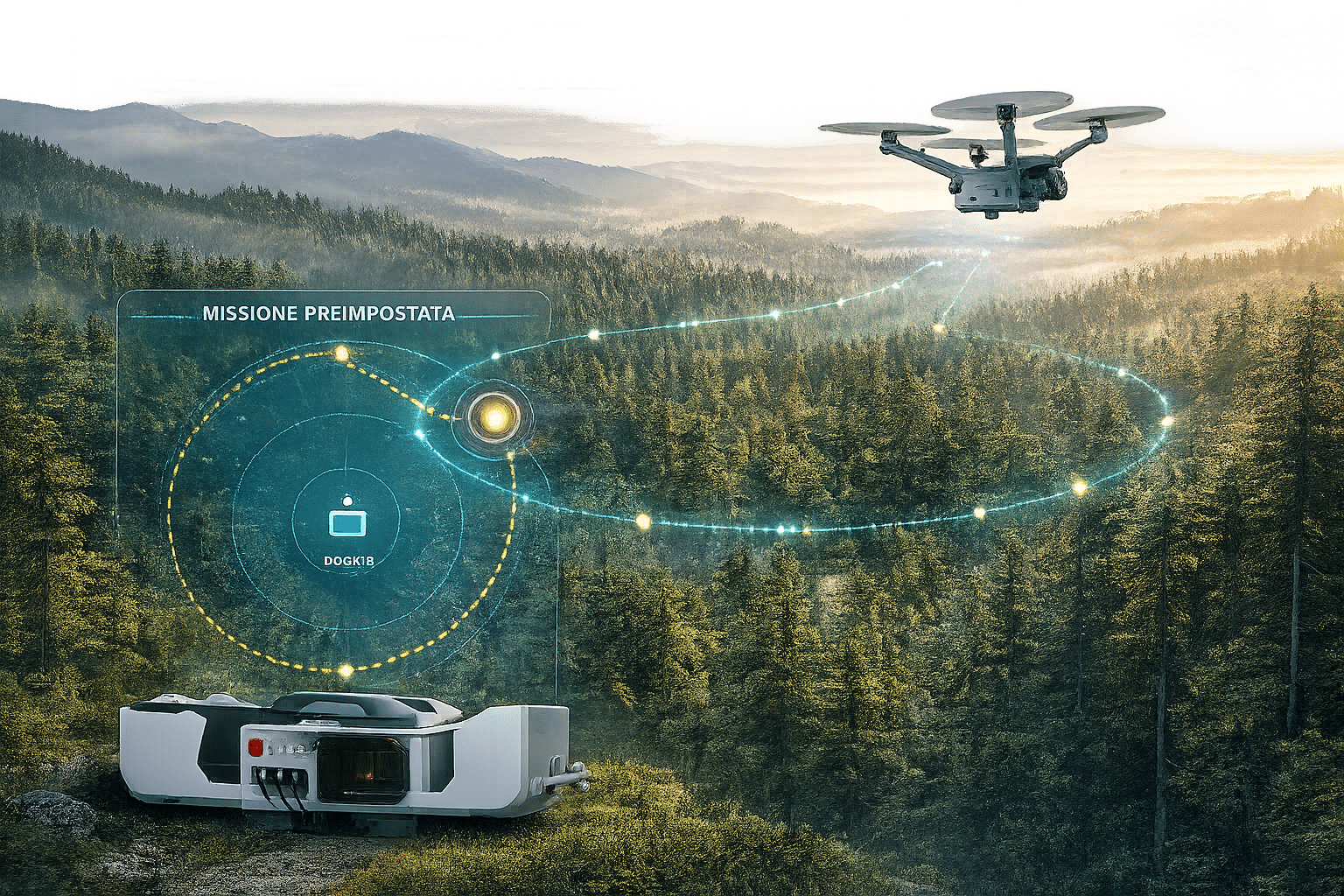
The drone runs scheduled autonomous patrol routes over at-risk forest areas: paths and schedule defined from the control center, with onboard AI analyzing vegetation cover to identify thermal anomalies, smoke and hotspots. When an alarm arrives from a Silvanet sensor or external VMS, the drone interrupts its current patrol and heads immediately to the GPS coordinates for thermal and visual verification.
The drone always watches. The AI never gets distracted.
FlytBase Enterprise programs the Dock 3 drone to run autonomous 24/7 patrols over the area of interest. Each route is optimized based on terrain profile, risk zones, weather and operational schedule.
During each patrol, onboard AI algorithms analyze the thermal and electro-optical stream in real time to identify anomalies: inconsistent temperature gradients, smoke, hotspots under the canopy, human presence in restricted areas. Every anomaly detected automatically generates a geo-referenced event for the remote operations center.
The system learns continuously: every false positive flagged by the operator enriches the model, progressively reducing noise and refining detection accuracy for the specific territory.
The Silvanet ecosystem — electronics that smell the fire
The Silvanet network by Dryad Networks turns the forest into a pervasive IoT platform: sensors that detect pyrolysis gases within the first 60 minutes of a 2×2 m fire, before flames are visible. Four modules working together to cover vast territories with 15-year autonomy, no lithium batteries and no maintenance required.

Wildfire Sensors
Solar-powered sensors mounted on tree trunks that detect pyrolysis CO, H₂ and VOCs at ppm level. Integrated Bosch BME688 AI for reliable fire recognition and false-positive rejection. They also monitor temperature, humidity and atmospheric pressure for forest health.
- 100 m radius for 60-min detection of a 2×2 m fire
- 15 years maintenance-free · solar-powered
- No lithium batteries · supercapacitors
- IP67 · -40°C to +85°C · 100% humidity
- LoRaWAN EU868/AS923/NA902-928 bands
- Installation at 3 m height on the tree

Silvanet Mesh Gateway
Extends the LoRaWAN network well beyond standard single-hop. Sensor messages jump from gateway to gateway in multi-hop self-healing mode until they reach the Border Gateway. Patented architecture with auto-configuration, automatic failover and OTA updates. Maintenance-free solar power.
- 2-6 km between Mesh Gateways · multi-hop
- Typically 100 sensors per gateway
- Automatic network configuration
- Self-healing with automatic failover
- Compatible with third-party LoRaWAN sensors
- Solar, 10-15 years maintenance-free

Silvanet Border Gateway
The edge gateway that closes the loop to the Cloud. Placed in a forest lodge or near settlements, it receives messages from Mesh Gateways and forwards them to the Silvanet Cloud platform. Triple redundant connectivity — 4G/LTE-M, Ethernet and SWARM satellite — for total coverage even in areas with no mobile signal.
- 20 Mesh Gateways managed per Border
- 4G/LTE-M + 2G/GPRS fallback
- Integrated Ethernet adapter
- SWARM satellite uplink for remote areas
- Starlink and Ku/C-band VSat compatible
- PoE or solar power (optional)

Silvanet Cloud
Central hub that ingests data from sensors via Mesh and Border Gateways. Interfaces through the Silvanet Site Management (dryad.app) web app and Silvanet Deployment mobile app. Multi-site, scalable, accessible anywhere there's an Internet connection. Each customer gets dedicated credentials with role-based permissions.
- Site Management web app (browser)
- Deployment mobile app (smartphone)
- Geographically distributed multi-site
- Real-time environmental data
- Automatic alarm notifications
- Native FlytBase integration via Flink
(1 Border + 20 Mesh + 2,000 sensors)
The Flink integration: the bridge between IoT and sky
The integration between Silvanet Cloud and FlytBase Enterprise happens through Flink Connectors, the native interoperability layer of the FlytBase platform. When a Silvanet sensor detects pyrolysis gases, the alarm flows through Mesh Gateway → Border Gateway → Silvanet Cloud → Flink → FlytBase in seconds.
FlytBase receives the precise GPS coordinates of the event, interrupts the current autonomous patrol and sends the Dock 3 drone to the exact point for thermal verification. All fully automated, with no human intervention.
The result: a single Dock 3 station can monitor and protect up to 70 km² of territory, thanks to the combined action of AI patrols and IoT sensor network.
Instant Trigger
Sensor alarm → drone in flight in < 60 sec
Thermal Verification
Thermal-camera AI for false-positive rejection
Scheduled AI Patrols
Autonomous patrols over the entire protected area
Multi-Site Scalability
More Docks + more sensors = unlimited territory
The Flinks — the universal language between drones and systems
Flinks are FlytBase Enterprise's one-click connectors that let the Dock 3 drone talk to any external system: from Silvanet wildfire IoT sensors to enterprise VMS, from air-traffic management systems to photogrammetry AI engines. A library of pre-built integrations plus the option to create custom Flinks for specific use cases.

Alarms Flink: when a Silvanet ground sensor talks to the drone in the sky
The "Alarms" Flink is the connector that integrates any external alarm system with the drone fleet. It's the exact mechanism that lets Silvanet sensors scattered through the forest transmit a fire alarm to the Dock 3 drone, which responds automatically in under 60 seconds.
The sensor detects pyrolysis gas → transmits via LoRaWAN → Silvanet Cloud → Alarms Flink → FlytBase Enterprise → drone mission generated → automatic takeoff → thermal + AI verification. All without human intervention, with precise geolocation and continuous heartbeat from the alarm source.
Stesso meccanismo per: motion sensors, fire alarms, gunshot detection, dispatch systems, distributed acoustic sensors.
Alarms
Integrates any alarm system: wildfire sensors, motion sensors, gunshot detection, dispatch systems. The drone responds to the alarm automatically.
Silvanet · Genetec · Milestone · Immix
Live Streaming
Connects drone and dock video streams to Video Management Systems (VMS) for security operations and real-time threat detection.
Genetec · Milestone · Data From Sky
Data Processing
AI-based software to generate high-resolution maps, 3D models, orthomosaics and custom reports for territory-specific applications.
DroneDeploy · Pix4D · Esri · Strayos
UTM
Air-traffic management systems for real-time situational awareness, enabling regulation-compliant BVLOS operations.
SkeyDrone · Altitude Angel · Involi
Detect & Avoid
Third-party systems for monitoring surrounding aircraft, ensuring compliance with BVLOS regulatory requirements.
uAvionix · Dedrone
Mission & Logs
Import detailed drone missions and manage resources, batteries and flight logs seamlessly across systems.
Airdata · Custom Flinks
From remote mountains to industrial sites
The Dock 3 operates where traditional surveillance fails: alpine peaks, isolated forest perimeters, offshore platforms, sprawling solar farms, port terminals. A single autonomous station replaces patrols, watchtowers and fixed-camera grids — no operators, no compromises.
From pyrolysis gas to fire extinguished
The entire chain — IoT sensor → cloud → drone → AI → fire brigade — closes in minutes. Every minute saved is a hectare of forest saved.
An invisible fire begins
A lightning strike, a cigarette, an electrical fault. Wood smolders slowly without flames, releasing CO and H₂ at ppm levels. No human eye, no satellite can see it yet. But Silvanet sensors 100 m away can.
Sensor → Mesh → Border → Cloud
The sensor detects the gas signature of pyrolysis. Bosch BME688 AI verifies it's not ambient noise (smog, agricultural smoke). The alarm travels the multi-hop LoRaWAN mesh, reaches the Border Gateway, and is transmitted to Silvanet Cloud along with GPS coordinates.
FlytBase receives the alarm via Flink
The Flink Connector forwards the event from Silvanet Cloud to FlytBase Enterprise. The platform interrupts the Dock 3 drone's current autonomous patrol and generates a verification mission with the alarming sensor's waypoints.
Thermal drone in autonomous flight
The Dock 3 opens, the drone takes off automatically. Radiometric EO/IR thermal camera active, AES-256-encrypted video stream transmitted in real time to the remote operations center.
False positive or real fire?
The drone arrives on site. Computer-vision algorithms analyze the thermal footage to confirm heat signatures, smoke or anomalous hotspots. If false positive: mission closed, drone returns to patrol. If confirmed: immediate escalation.
Multi-channel alert to the fire brigade
The system automatically notifies fire services, civil protection and the territorial coordination center with: precise coordinates, live thermal footage, weather data, area accessibility, sensor history.
Fire tamed in early stage
The fire is intercepted while still small and contained. Limited resources are enough: a few water trucks, a Canadair only if needed. Hectares saved, lives protected, ecosystems preserved.
A wildfire detected during pyrolysis is a wildfire defeated. A wildfire detected when the flames are visible miles away is a war already lost. The Silvanet + Dock 3 + FlytBase integration doesn't fight fire: it stops fire from ever becoming an enemy.
— DroneBase Aerial Surveillance Division
Three technologies. One autonomous system.
The integration of Silvanet, FlytBase and Dock 3 isn't a sum of products — it's a multiplication of capabilities. Each component amplifies the others: sensors extend the drone's eye, the drone verifies sensor alarms, the cloud orchestrates everything in real time.
70 km² Protected per Dock
With a complete Silvanet network (1 Border, 20 Mesh, ~2,000 sensors) a single Dock 3 covers up to 70 km² of territory. Linear scalability by adding docks and gateways.
Ultra-Early Detection
IoT sensors detect the fire during smouldering, 30-60 minutes before flames are visible. A critical time advantage for the Golden Hour.
Dual AI Verification
First filter: Bosch BME688 onboard sensor AI. Second filter: thermal-drone computer-vision AI. False positives reduced to operationally manageable levels.
Scheduled AI Patrols
FlytBase schedules autonomous 24/7 patrols over the area. Onboard AI continuously analyzes the thermal stream, identifying anomalies independently of the sensors.
Resilient Connectivity
Self-healing Silvanet LoRaWAN mesh + Border 4G/LTE/Ethernet/satellite. Redundant FlytBase 4G/5G/Ethernet. System operational even without mobile coverage.
Zero Maintenance for 15 Years
Solar-powered sensors with supercapacitors, no lithium batteries. Set up once, forget for 15 years. ROI optimized from initial CAPEX through the long term.
Cyber-Secure End-to-End
AES-256 encryption across the entire chain: sensor → mesh → border → cloud → FlytBase → control center. GDPR, ISO 27001, NIS compliant. Immutable audit logs.
Cloud-Native & Scalable
Natively scalable architecture: from a single site to entire regional territories. Multi-tenant remote operations center, unified dashboard, continuous OTA updates.
Regulatory Compliance
System designed for compliance with EU Civil Protection, EU Forest Strategy, PNIEC, EASA Specific Category. Support for PNRR tenders and territorial wildfire-prevention funding.
Integrated Ecosystem vs Traditional Methods
A direct comparison between the integrated DroneBase + Silvanet + FlytBase ecosystem and traditional surveillance technologies.
Who needs continuous forest protection
The DroneBase + Silvanet ecosystem is the strategic answer for public and private organizations managing significant forest, agricultural, infrastructural or natural assets.
Public Administration
Regions, provinces, municipalities and mountain communities responsible for vast public forest areas and at-risk wildland-urban interfaces.
Civil Protection & Wildfire Service
Continuous support to wildfire response operations with non-stop monitoring, automatic alerting and live visualization of emerging hotspots.
Forestry
Forest consortia, sawmills and woodland management companies overseeing extensive areas of premium timber vulnerable to destructive fires.
Strategic Infrastructure
Power transmission lines, gas pipelines, railways and motorways crossing extensive forest areas. Double risk: both targets and triggers of fires.
Solar Farms
Utility-scale solar plants in semi-arid areas surrounded by vegetation. A nearby fire can compromise hundreds of millions in assets.
Tourism & Hospitality
Tourist villages, eco-resorts, mountain hotels and farm stays in forested areas. Protecting guests, assets and business continuity through high-risk seasons.
Parks & Protected Areas
National parks, regional reserves, Natura 2000 sites: areas of high natural value where loss of vegetation cover is irreversible ecological damage.
Wildland-Urban Interface
Municipalities and residential settlements adjacent to forest areas. Protecting homes, schools, hospitals and evacuation routes.
Military Bases & Sensitive Sites
Defense installations, communication centers and classified sites in remote forest areas where traditional access for verification is limited.
Insurance & Risk Management
Insurance companies covering forest, agricultural and residential assets in fire-risk areas: real-time monitoring for premiums and claims.
Precision Agriculture
Vineyards, olive groves, orchards and large estates: protecting premium crops and adjacent forest areas, with integration of agronomic and microclimatic data.
Industrial Sites & Storage
Timber yards, sawmills, paper mills and biomass plants: where a small flare-up can quickly escalate into a catastrophic event.
The ecosystem in numbers
Performance certified through independent testing and validated across 30+ industry sectors.
Protect your territory before next summer
Our team of specialists analyzes the specific needs of your territory, simulates sensor coverage on real maps, and designs the most suitable protection ecosystem. Free consultation and feasibility study, no commitment.