Georadar & Magnetometer Combo
Showing all 4 results
Drones with Georadar and Magnetometer: Advanced Technology for Precision Geophysical Analysis
Drones with Georadar and Magnetometer are an innovative solution for performing precision geophysical surveys, ideal for subsurface analysis over large areas, hard-to-reach areas, and complex environments. Through the integration of a Georadar and a Magnetometer, these systems enable the detection of geological anomalies, metal objects, and underground structures with speed and accuracy, offering comprehensive results in a single operation.
Why Choose Drones with Georadar and Magnetometer?
- Safe and Quick Access: Drones enable surveys in dangerous or hard-to-reach areas, eliminating risks to personnel.
- Accuracy and Completeness: The combination of Georadar and Magnetometer ensures detailed geophysical data for accurate subsurface analysis.
- Operational Efficiency: Coverage of large areas in a shorter time than traditional methods, reducing costs and resources.
- Versatility: Ideal for various applications, such as archaeology, geology, construction, and environmental monitoring.
Applications of Drones with Georadar and Magnetometer
- Archaeology: Survey of ancient structures and buried objects without invasive excavation.
- Geology: Identification of stratigraphic anomalies and surveys for detailed geological analysis.
- Construction and Civil Engineering: Subsurface assessment for construction and maintenance projects.
- Mining Industry: Identification of mineral deposits and monitoring of mining areas.
- Environmental Monitoring: Locating metal contaminants or buried objects for remediation.
-
Georadar, Georadar & Magnetometer Combo, UgCS - SPH
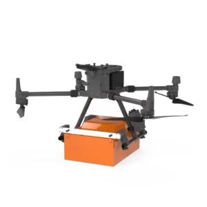
Georadar Drone – Zond Aero 1000 NG GPR
0 out of 5(0)The Zond Aero 1000 is an ultralight, single-unit ground penetrating radar (GPR) system specially designed for portable solutions. Compatible with DJI Matrice 300 and 350 drones, this georadar offers advanced performance for geophysical and archaeological survey applications.
SKU: n/aFrom 24.399,00 € TAX Included This product has multiple variants. The options may be chosen on the product page -
Georadar, Georadar & Magnetometer Combo, UgCS - SPH
Georadar Drone – Zond Aero 500 NG
0 out of 5(0)The Zond Aero 500 is an ultralight, single-unit ground penetrating radar (GPR) system specially designed for portable solutions. Compatible with DJI Matrice 300 and 350 drones, this georadar offers advanced performance for geophysical and archaeological survey applications.
SKU: n/aFrom 21.959,00 € TAX Included This product has multiple variants. The options may be chosen on the product page -
Georadar & Magnetometer Combo, Magnetometer
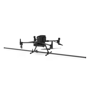
Drone magnetometer – Sensys MagDrone R3
0 out of 5(0)The Sensys MagDrone R3 is an ultra-portable magnetometer for drones, compatible with DJI M300 and M350 RTK. Designed for surveys over large areas, it is ideal for operations inaccessible on the ground. Equipped with built-in GPS, it supports optimal geotagging and connects to external GPS. Perfect for mining exploration, security, archaeology and underground structure surveying.
SKU: n/aFrom 19.520,00 € TAX Included This product has multiple variants. The options may be chosen on the product page -
Georadar & Magnetometer Combo, Magnetometer
Drone magnetometer – Sensys MagDrone R4
0 out of 5(0)The Sensys MagDrone R4 is an ultra-portable magnetometer for drones, compatible with DJI M300 and M350 RTK. Designed for surveys over large areas, it is ideal for operations inaccessible on the ground. Equipped with built-in GPS, it supports optimal geotagging and connects to external GPS. Perfect for mining exploration, security, archaeology and underground structure surveying.
SKU: n/aFrom 47.580,00 € TAX Included This product has multiple variants. The options may be chosen on the product page
Showing all 4 results