UgCS - SPH
Showing all 5 results
Discover UgCS, the advanced drone mission planning and control software designed for professionals who need automated and precise operations. UgCS offers an intuitive interface for creating complex flight paths, supporting a wide range of drones and sensors.
Main features:
- Advanced mission planning: Define specific waypoints, altitudes and actions for each segment of the flight.
- Multi-sensor support: Easily integrate cameras, LiDAR and other sensors to capture diverse data.
- Extended compatibility: Works with numerous drone models, offering operational flexibility.
- 3D terrain planning: Use 3D maps for accurate planning in complex environments.
Main applications:
- Photogrammetry and mapping: Create detailed orthomosaics and 3D models for topographic surveys.
- Industrial inspections: Monitors infrastructure such as power lines, pipelines and plants.
- Precision agriculture: Analyze crop status and optimize agricultural resources.
With UgCS, you can optimize your drone operations, ensuring efficiency and accuracy in every mission.
-
Georadar, Georadar & Magnetometer Combo, UgCS - SPH
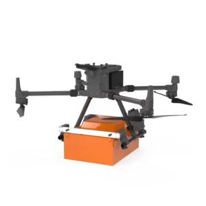
Georadar Drone – Zond Aero 1000 NG GPR
0 out of 5(0)The Zond Aero 1000 is an ultralight, single-unit ground penetrating radar (GPR) system specially designed for portable solutions. Compatible with DJI Matrice 300 and 350 drones, this georadar offers advanced performance for geophysical and archaeological survey applications.
SKU: n/aFrom 24.399,00 € TAX Included This product has multiple variants. The options may be chosen on the product page -
Georadar, Georadar & Magnetometer Combo, UgCS - SPH
Georadar Drone – Zond Aero 500 NG
0 out of 5(0)The Zond Aero 500 is an ultralight, single-unit ground penetrating radar (GPR) system specially designed for portable solutions. Compatible with DJI Matrice 300 and 350 drones, this georadar offers advanced performance for geophysical and archaeological survey applications.
SKU: n/aFrom 21.959,00 € TAX Included This product has multiple variants. The options may be chosen on the product page -
UgCS - SPH
UgCS
0 out of 5(0)UgCS is advanced software for drone mission planning and control. It supports photogrammetry, LiDAR and aerial scanning, optimizing professional operations. Compatible with various payloads, it offers an intuitive interface for automated missions.
SKU: n/aFrom 890,00 € TAX Included This product has multiple variants. The options may be chosen on the product page
Showing all 5 results