
Bathymetry Drones: Advanced Technology for Precision Underwater Surveys
Bathymetry drones are an innovative solution for mapping and analyzing the seabed, lake, and river bed. Equipped with advanced echosounders and sensors, these drones enable high-precision bathymetric surveys, even in areas that are difficult to access or dangerous to humans. Why choose drones for bathymetry?- Access to remote areas: They easily reach areas inaccessible by traditional means, such as lakes, rivers and rugged coastlines.
- Operational safety: They eliminate the risks associated with manual diving operations, protecting personnel from potential hazards.
- Efficiency and speed: They cover large areas in less time, optimizing surveying operations.
- High-quality data: Provide detailed information on seafloor morphology, essential for environmental and engineering studies.
- Environmental monitoring: Aquatic ecosystem analysis and environmental impact assessment.
- Civil engineering: Design and maintenance of infrastructure such as bridges, dams and ports.
- Navigation: Updating nautical charts and identifying submerged obstacles.
- Scientific research: Underwater geological and archaeological studies.
Featured products

Combo Bathymetry
Showing the single result
-
✓ Pronta consegna
Advanced Bathymetric Survey Technology
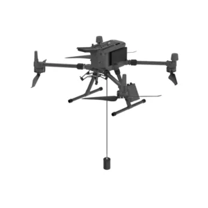
Our combo bathymetry solutions integrate cutting-edge drone platforms with precision sonar systems for comprehensive underwater mapping. The EchoLogger ECT D052S represents the pinnacle of bathymetric survey technology, combining high-frequency sonar with advanced positioning systems for centimeter-level accuracy.
These systems enable rapid deployment for hydrographic surveys, eliminating the need for manned vessels in shallow or hazardous waters while maintaining survey-grade precision required for professional marine applications.
Multi-Frequency Sonar Capabilities
The EchoLogger ECT D052S features dual frequency sonar technology that adapts to varying water conditions and survey requirements. Lower frequencies penetrate deeper waters and sediment layers, while higher frequencies provide enhanced resolution for detailed seafloor characterization.
This versatility makes our bathymetry combos suitable for diverse applications from shallow water surveys to deep harbor inspections, delivering consistent results across different marine environments.
Integrated Navigation and Data Processing
Our bathymetry drone combinations feature integrated GPS/GNSS positioning systems that ensure precise georeferencing of all depth measurements. Real-time data visualization allows operators to monitor survey progress and adjust flight patterns for optimal coverage.
Advanced data processing capabilities generate immediate bathymetric charts, cross-sections, and 3D models directly in the field, significantly reducing post-processing time and enabling rapid decision-making for time-critical projects.
Professional Survey Applications
These bathymetry drone systems excel in hydrographic surveying, port and marina inspections, dredging volume calculations, and environmental monitoring. The compact design allows access to areas impossible for traditional survey vessels while maintaining the accuracy standards required for official nautical charting.
Integration with industry-standard survey software ensures seamless workflows with existing hydrographic data processing systems and compliance with international surveying standards.
Why buy from DroneBase
DJI Gold Partner Excellence
Certified expertise and priority support for professional bathymetry applications.
ISO 9001:2015 Quality
Guaranteed quality management systems for reliable survey equipment delivery.
Professional Integration
Complete turnkey bathymetry solutions with training and technical support included.
Italian Technical Excellence
Local expertise in marine surveying with immediate technical assistance from Rimini.
Frequently asked questions
The EchoLogger ECT D052S delivers survey-grade accuracy with depth measurement precision typically within ±2cm depending on water conditions and frequency settings, meeting international hydrographic surveying standards.
Maximum survey depth depends on water clarity and sonar frequency selection, typically ranging from 50-200 meters. Shallow water performance is exceptional with millimeter-level precision in depths under 10 meters.
Yes, you need appropriate drone pilot certification and may require additional permits for marine surveys. We provide guidance on regulatory compliance and can assist with certification requirements for professional operators.
Our systems include professional survey software for real-time data visualization, post-processing, and chart generation. Integration with major hydrographic software packages like QINSy and HYPACK is supported.
Drone bathymetry offers faster deployment, access to shallow or restricted areas, lower operational costs, and reduced safety risks while maintaining comparable accuracy to traditional single-beam echo sounders.
We provide comprehensive training covering drone operation, sonar principles, survey planning, data collection procedures, and processing workflows. Training can be conducted at our Rimini facility or on-site at your location.
Want a consultation or a demo?
Our DJI Enterprise certified technicians help you choose the right configuration. No commitment.
+39 0541 1790411


