
- High resolution: Advanced sensors for detailed and accurate images.
- Seamless integration: Full compatibility with DJI drones for optimal operation.
- Operational efficiency: Designed for mapping and inspection missions, ensuring reliability and speed.
- Photogrammetry: Creating 3D maps and models for urban planning, agriculture and civil engineering.
- Industrial inspections: Analysis of infrastructure such as bridges, power lines and pipelines, detecting anomalies and trouble spots.
Featured products

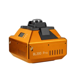
BL200 Pro - 210MP Oblique Camera DJI M350
210MP oblique camera with 5 HOYA lenses for professional photogrammetry on DJI M350. Aerospace alloy construction and OLED screen for maximu
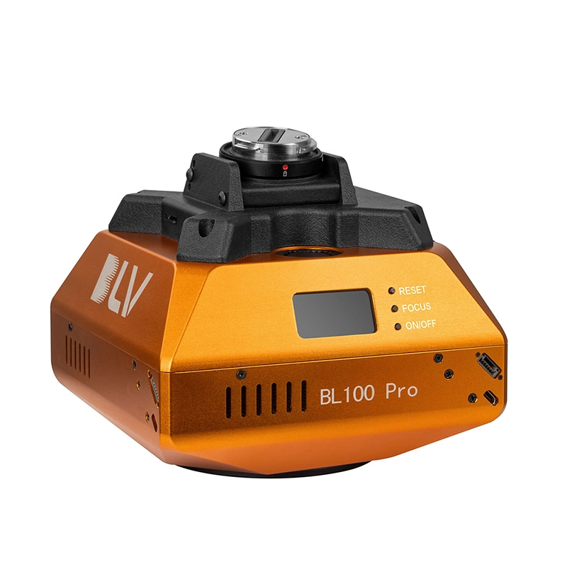
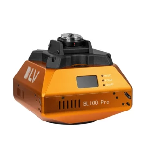
BL100 Pro - 120MP Oblique Camera DJI M350
120MP oblique camera for professional photogrammetry on DJI M350/M300 RTK. HOYA™ calibrated lenses and PSDK module for maximum survey precis
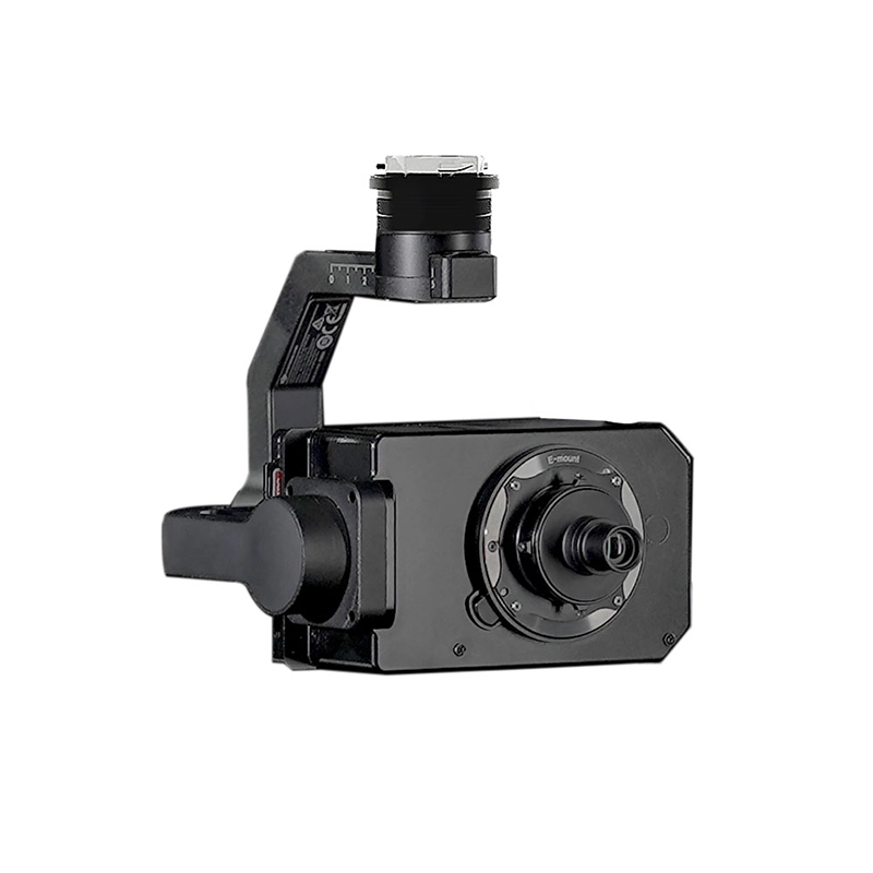
BL6100 Xport - 61MP DJI M350 Camera
61MP full-frame camera with HOYA™ lenses for professional aerial surveys on DJI M350. Precise gimbal stabilisation and ultra-high-resolution
Cameras
Showing all 3 results
-
✓ Pronta consegna
-
✓ Pronta consegna
-
✓ Pronta consegnaCameras, DJI Matrice 350 RTK series
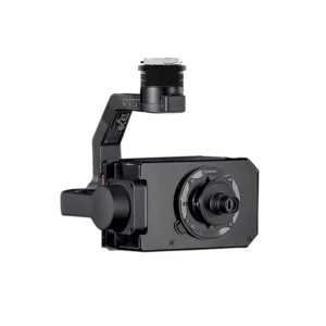
BL6100 Xport – 61MP DJI M350 Camera
61MP full-frame camera with HOYA™ lenses for professional aerial surveys on DJI M350. Precise gimbal stabilisation and ultra-high-resolution imagery for mapping and photogrammetry. Available at DroneBase, DJI Gold 5 Dealer.
SKU: BLV001
Advanced Oblique Photography Systems
Oblique photography revolutionizes aerial surveying by capturing images at multiple angles simultaneously. Our BL200 Pro and BL100 Pro systems feature sophisticated 5-camera configurations that record nadir and oblique views in a single flight pass. This multi-perspective approach dramatically improves photogrammetric reconstruction accuracy and provides comprehensive facade detail for urban modeling, building inspection, and infrastructure assessment.
High-Resolution Sensors for Precision Mapping
Professional mapping demands exceptional image quality and detail. Our camera systems feature high-resolution sensors ranging from 61MP to 210MP, ensuring sub-centimeter accuracy when combined with the DJI Matrice 350 RTK's precision positioning. These advanced sensors capture fine details essential for engineering surveys, archaeological documentation, and precision agriculture applications.
The integrated workflow with DJI Terra and third-party photogrammetry software streamlines data processing, reducing time from flight to final deliverable.
Seamless DJI M350 RTK Integration
Designed specifically for the DJI Matrice 350 RTK platform, our camera payloads integrate seamlessly with the aircraft's advanced flight systems. Intelligent flight modes, automated mission planning, and real-time image preview enhance operational efficiency while maintaining the highest safety standards. The cameras communicate directly with DJI Pilot 2, providing instant access to capture settings and flight parameters.
Enterprise-Grade Build Quality
Built to withstand demanding field conditions, these professional camera systems feature robust construction and weather-resistant designs. Precision-engineered gimbals ensure stable imagery even in challenging weather conditions, while advanced shock-mounting systems protect sensitive components during transport and operation. Each system undergoes rigorous quality testing to meet enterprise reliability standards.
Comprehensive Software Ecosystem
Our camera systems work seamlessly with industry-leading photogrammetry and GIS software platforms. Native compatibility with DJI Terra, Pix4D, and Agisoft Metashape ensures smooth workflow integration from flight planning through final deliverable generation. Advanced metadata embedding and GPS synchronization enable precise georeferencing and automated processing workflows.
Why buy from DroneBase
DJI Gold 5 Dealer Expertise
Certified expertise and direct manufacturer support ensure optimal system configuration and performance.
ISO 9001:2015 Certified
Quality management certification guarantees consistent service standards and product reliability.
Enterprise-Focused Solutions
Specialized knowledge of professional applications ensures the right camera system for your specific requirements.
Complete Technical Support
Comprehensive training, maintenance, and ongoing technical assistance from our certified specialists.
Frequently asked questions
Professional drone camera pricing varies based on resolution and capabilities. Contact our team for detailed quotations tailored to your specific requirements and volume needs. We offer competitive enterprise pricing and flexible financing options.
Camera operation follows standard drone regulations, but you'll need appropriate pilot certification for commercial operations. Our team can guide you through regulatory requirements and recommend certified training providers in your region.
Oblique cameras excel in urban planning, building inspections, 3D city modeling, infrastructure monitoring, insurance assessments, and archaeological surveys. The multi-angle capture provides comprehensive facade detail impossible with traditional nadir photography.
When combined with DJI M350 RTK positioning and proper ground control points, these systems achieve sub-centimeter accuracy. The BL200 Pro can deliver accuracy suitable for engineering-grade surveys and construction monitoring applications.
Our cameras integrate with DJI Terra, Pix4D Mapper, Agisoft Metashape, Bentley ContextCapture, and other leading photogrammetry platforms. We provide workflow guidance and software recommendations based on your application requirements.
Flight time varies by camera system and flight conditions. The M350 RTK typically achieves 35-45 minutes with camera payloads, depending on configuration. We can provide specific performance data for your operational requirements.
Want a consultation or a demo?
Our DJI Enterprise certified technicians help you choose the right configuration. No commitment.
+39 0541 1790411


