
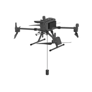
- DJI drone compatibility: Designed to integrate seamlessly with platforms such as the DJI Matrice 300 RTK and DJI Matrice 350 RTK, ensuring stability and reliability during operations.
- Data accuracy: Fishfinders provide accurate measurements of depth and bottom structure, which are essential for applications such as nautical charting, environmental monitoring, and underwater inspections.
- Ease of use: With intuitive interfaces and integration with dedicated software, you can plan missions and analyze collected data with ease.
- Bathymetric Surveys: Creating detailed seabed maps for navigation and water resource management.
- Environmental monitoring: Aquatic ecosystem assessment and sediment monitoring.
- Underwater inspections: Analysis of underwater structures such as dams, bridges and marine infrastructure.
Featured products
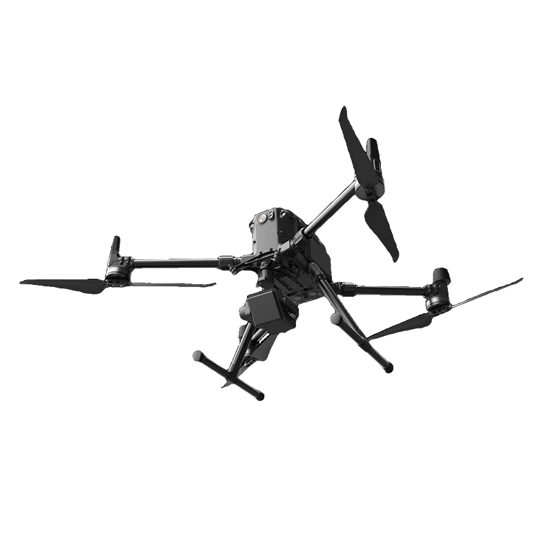
Water Flow Measurement System DJI Matrice 350
Doppler radar system for measuring water flow velocity, level and discharge in real-time on DJI M350. Advanced technology with IP protection

EchoLogger ECT D052S
Dual-frequency 50/200 kHz echosounder for bathymetric surveys up to 200m with DJI drones. Penetrates soft sediments whilst detecting hard se
EchoLogger ECT 400S
Ultracompact echo sounder at 450kHz for precision bathymetric surveys, with integrated transducer and inclination sensor for professional un
Echosounder
Showing all 4 results
-
✓ Pronta consegna
-
✓ Pronta consegna
-
✓ Pronta consegna
-
✓ Pronta consegna

Advanced Bathymetric Survey Capabilities
Our professional echosounder systems revolutionize underwater surveying by combining drone mobility with precision acoustic measurement technology. The Water Flow Measurement System integrated with the DJI Matrice 350 provides comprehensive hydrological data collection capabilities, enabling accurate flow velocity measurements and volumetric calculations in rivers, channels, and coastal environments.
These systems deliver centimeter-level accuracy in depth measurement while simultaneously capturing flow dynamics, making them essential tools for flood management, environmental assessment, and hydraulic engineering projects.
EchoLogger ECT Series: Precision Acoustic Sensing
The EchoLogger ECT D052S and ECT 400S represent the pinnacle of drone-mounted echosounder technology, each optimized for specific survey requirements. The D052S operates at 52kHz, providing excellent penetration in shallow waters and sediment characterization, while the 400S high-frequency system delivers exceptional resolution for detailed bottom mapping and small object detection.
Both systems feature advanced signal processing algorithms that automatically compensate for water conditions, ensuring consistent data quality across varying environmental parameters including temperature gradients, turbidity, and acoustic interference.
Real-Time Data Processing and Integration
Our echosounder solutions feature sophisticated data processing capabilities that deliver immediate survey results during flight operations. Real-time depth profiling and flow calculations enable operators to adjust survey patterns dynamically, ensuring complete coverage and optimal data density for project requirements.
Integration with professional GIS software and hydrographic survey platforms streamlines the workflow from data collection to final deliverables, supporting standard formats including XYZ, CSV, and industry-specific bathymetric file types.
Multi-Environment Survey Applications
These professional echosounder systems excel across diverse aquatic environments, from river flow monitoring and lake bathymetry to coastal zone management and port infrastructure inspection. The drone-mounted configuration enables access to previously unreachable areas while maintaining survey accuracy and operator safety.
Applications span environmental compliance monitoring, sediment transport studies, navigation channel surveys, and emergency response scenarios where rapid bathymetric assessment is critical for decision-making.
Enterprise-Grade Reliability and Support
As a DJI Gold 5 Dealer with ISO 9001:2015 certification, DroneBase ensures each echosounder system meets the highest professional standards for accuracy, durability, and operational reliability. Our comprehensive support includes technical training, calibration services, and ongoing maintenance to maximize your survey productivity.
Each system undergoes rigorous quality testing and comes with complete documentation, calibration certificates, and professional technical support to ensure seamless integration into your surveying operations.
Why buy from DroneBase
DJI Gold 5 Expertise
Certified elite dealer with deep technical knowledge of professional drone integration and echosounder systems.
ISO Quality Assurance
ISO 9001:2015 certified processes ensure consistent quality and reliability in every echosounder solution delivered.
Professional Training
Comprehensive technical training and ongoing support maximize your team's survey capabilities and productivity.
Complete Integration
Turnkey solutions combining drone platforms, echosounder technology, and professional software for immediate deployment.
Frequently asked questions
Professional echosounder systems typically range from €15,000 to €45,000 depending on frequency specifications, integration complexity, and included software packages. Contact our specialists for detailed quotations based on your specific survey requirements.
Yes, you need both appropriate drone pilot certification and may require hydrographic survey permits depending on your location and application. We provide guidance on regulatory requirements and can recommend certified training programs.
Our professional echosounder systems deliver depth accuracy of ±2-5cm under optimal conditions, with flow measurement precision within 2-3% of actual values. Accuracy depends on water conditions, survey altitude, and environmental factors.
Yes, our echosounder systems are designed for both freshwater and saltwater applications. The systems automatically adjust for salinity variations that affect acoustic propagation, ensuring consistent accuracy across different water types.
Systems include professional data collection software, real-time processing applications, and export utilities for major GIS platforms. Advanced hydrographic processing software packages are available as optional upgrades.
The 52kHz ECT D052S system typically measures depths up to 100 meters, while the 400kHz ECT 400S is optimized for shallow water applications up to 20 meters with superior resolution for detailed bottom characterization.
Want a consultation or a demo?
Our DJI Enterprise certified technicians help you choose the right configuration. No commitment.
+39 0541 1790411


