
Drones with 3D LiDAR: Advanced Technology for Precision Three-Dimensional
Surveys Drones with LiDAR are an innovative solution for performing precision three-dimensional surveys, ideal for large areas, hard-to-access areas and complex projects. Using LiDAR (Light Detection and Ranging) technology, these systems enable detailed data capture to create accurate 3D models, overcoming obstacles such as dense vegetation or uneven terrain. Why Choose Drones with 3D LiDAR? Safe and Quick Access: Drones enable surveys in difficult or dangerous areas without risk to personnel. Accuracy and Completeness: LiDAR technology captures millions of data points per second, ensuring detailed and reliable 3D models. Operational Efficiency: Coverage of large areas in a shorter time than traditional methods, optimizing time and resources. Versatility: Perfect for applications in topography, engineering, geology, archaeology and environmental monitoring.Applications of Drones with 3D LiDAR
Topography: Creation of elevation maps and precision 3D models for terrain analysis. Civil Engineering: Monitoring and design of infrastructure such as bridges, roads and railways. Archaeology: Identification of buried structures and mapping of archaeological sites without invasive intervention. Environmental Monitoring: Study of vegetation, forest management and detection of climate or environmental changes. Mining Industry: Volume measurement surveys and mapping of quarries and mining sites.Discover Our Drones with LiDAR 3D
Explore our range of drones, designed to ensure accuracy and reliability in three-dimensional surveys. Get detailed 3D models and comprehensive results in any environment with our advanced technologies and dedicated technical support. Contact us today for a personalized consultation or field demonstration!Featured products
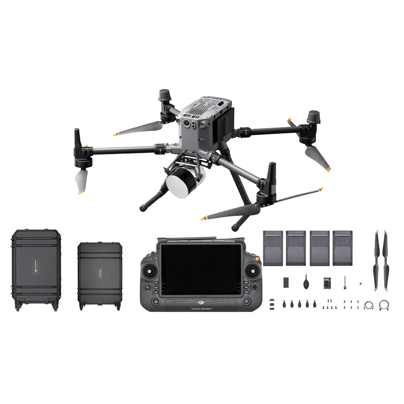
DJI Lidar Matrice 350 + TopoDrone Lidar 100+ Combo.
Complete M350 Lidar system with TopoDrone 100+ and RTK precision for professional 3D scanning of infrastructure and large structures. Includ
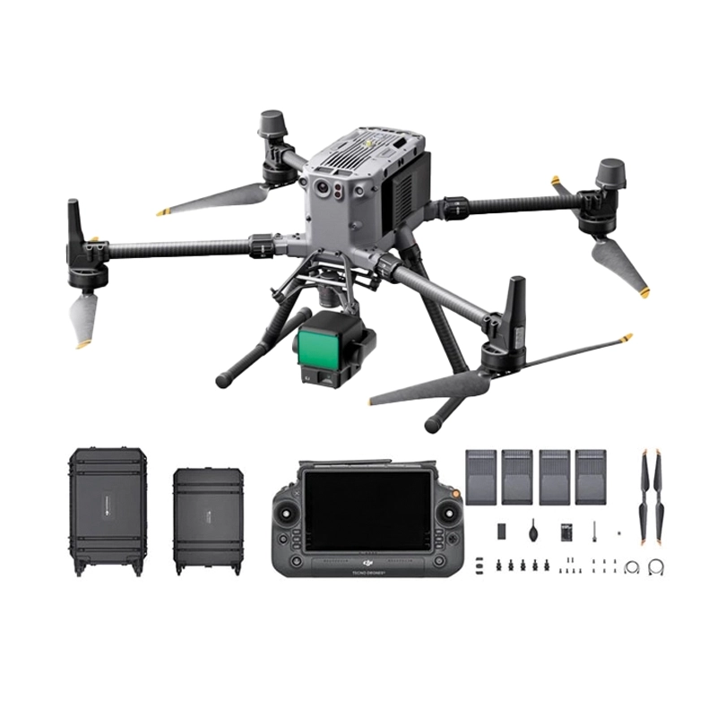
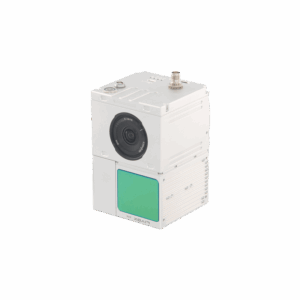
DJI Matrice 350 + Zenmuse L2 3D Lidar Combo
Integrated 3D Lidar system with Zenmuse L2 and Matrice 350 RTK for professional aerial scanning of bridges, infrastructure and large structu
3D Lidar
Showing all 5 results
-
✓ Pronta consegna

Advanced LiDAR Technology for Professional Applications
Modern 3D LiDAR technology revolutionizes how professionals approach surveying, mapping, and inspection tasks. Our laser scanner portfolio delivers sub-centimeter accuracy with rapid data acquisition, enabling precise digital twin creation and comprehensive site analysis.
From topographic surveys to power line inspection, these systems generate millions of measurement points per flight, creating detailed 3D models that traditional photogrammetry cannot match in challenging conditions like dense vegetation or low-light environments.
GS Series Laser Scanners: Precision Engineering
The GS series represents the pinnacle of airborne LiDAR technology, engineered for demanding professional environments. Each scanner incorporates advanced laser ranging technology with integrated IMU systems for precise georeferencing and exceptional data quality.
These systems excel in applications requiring millimeter-level precision, including construction monitoring, mining operations, and archaeological documentation. The dual-return capability captures both canopy and ground surfaces simultaneously, essential for forestry and environmental monitoring projects.
Integration with Professional Drone Platforms
Our LiDAR scanners integrate seamlessly with enterprise-grade DJI platforms, creating complete surveying solutions. The systems feature real-time data preview and automated flight planning capabilities, maximizing operational efficiency while ensuring comprehensive coverage.
Professional payload mounting systems ensure stable data acquisition even in challenging weather conditions, while integrated GPS/GNSS modules provide centimeter-level positioning accuracy essential for large-scale surveying projects.
Applications Across Industries
Construction and infrastructure professionals utilize LiDAR for progress monitoring, volume calculations, and as-built documentation. The technology excels in power line corridor mapping, bridge inspection, and railway monitoring where precision and safety are paramount.
Mining operations leverage LiDAR for stockpile management, pit planning, and safety monitoring, while environmental consultants use the technology for flood modeling, habitat mapping, and coastal erosion studies. Archaeological teams employ LiDAR to reveal hidden structures beneath vegetation canopy.
Data Processing and Analysis Solutions
Raw LiDAR point clouds require specialized processing software to extract actionable insights. Our solutions include comprehensive data processing workflows that transform millions of measurement points into accurate digital elevation models, contour maps, and 3D visualizations.
Professional software suites enable advanced classification algorithms, automatic feature extraction, and seamless integration with existing CAD and GIS workflows, ensuring your LiDAR investment delivers maximum value across your organization.
Professional Support and Training
As an ISO 9001:2015 certified dealer, DroneBase provides comprehensive technical support throughout your LiDAR implementation journey. Our certified technicians offer on-site training, system calibration, and ongoing maintenance services to ensure optimal performance.
We understand that LiDAR technology represents a significant investment, which is why we provide detailed consultation services to match the right system configuration to your specific application requirements and operational constraints.
Why buy from DroneBase
ISO 9001:2015 Quality Assurance
Certified quality management ensures reliable products and professional service standards.
DJI Gold 5 Dealer Status
Highest level DJI partnership provides access to latest technology and priority support.
Expert Technical Consultation
Our specialists guide you to the optimal LiDAR solution for your specific applications.
Comprehensive Integration Support
Complete setup, training, and ongoing technical assistance for seamless deployment.
Frequently asked questions
Our GS series laser scanners deliver ±2cm accuracy at 100m range under optimal conditions. Actual accuracy depends on flight altitude, terrain conditions, and GPS signal quality. For precision surveying applications, we recommend flight altitudes between 50-120m for optimal results.
The GS series scanners are designed for enterprise DJI platforms including the Matrice 350 RTK and Matrice 300 RTK. Payload integration requires professional mounting systems and may affect flight time. Our technical team provides detailed compatibility assessments for your specific platform.
LiDAR data processing requires specialized software capable of handling large point cloud datasets. We recommend professional solutions that include classification algorithms, filtering tools, and export capabilities to common GIS formats. Training on data processing workflows is included with system purchase.
Professional LiDAR scanner pricing varies based on specifications, accuracy requirements, and included software packages. Systems typically range from mid-five to six-figure investments. Contact our sales team for detailed quotations based on your specific application requirements and volume needs.
LiDAR excels in challenging conditions where photogrammetry struggles: dense vegetation penetration, low-light environments, and uniform surfaces. It provides direct distance measurements rather than calculated positions, delivering superior accuracy for vertical mapping and detailed elevation models.
LiDAR drone operations require standard commercial drone licenses (A2 CofC in Europe) plus additional considerations for survey-grade equipment. Some applications may require surveyor licensing depending on local regulations. We provide guidance on regulatory requirements for your specific use case and location.
Want a consultation or a demo?
Our DJI Enterprise certified technicians help you choose the right configuration. No commitment.
+39 0541 1790411


