DJI Zenmuse L3 — Long-Range Survey-Grade Aerial LiDAR with 950 m Range, 16 Returns and Dual 100 MP 4/3" RGB Camera
The DJI Zenmuse L3 is DJI's next-generation airborne LiDAR system for professional mapping and large-scale infrastructure surveys: 1535 nm laser with range up to 950 m (2,000 m on high-reflectivity surfaces), 16 returns per pulse for maximum vegetation penetration, dual 4/3" 100 MP RGB camera for high-resolution coloured point clouds and coverage up to 100 km² per day. With vertical accuracy of 3 cm at 120 m, 5 cm at 300 m and 10 cm at 500 m, it is the survey-grade solution for topography, civil engineering, forest management and extended infrastructure inspection. Compatible exclusively with DJI Matrice 400, it includes DJI Care Enterprise Plus 1 Year in the box. Available in ready stock from DroneBase with GrenkeLeasing operational rental from €334.47/month.
Explore the main operational profiles
The Zenmuse L3 is a unique system suited to very different scenarios — from large-scale territorial mapping to long-range linear infrastructure inspection.
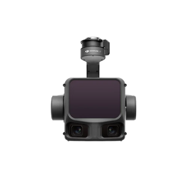
DJI Zenmuse L3
Showing the single result
-
✓ Ready to shipDJI Matrice 400, DJI Payload, DJI Zenmuse L3
DJI Zenmuse L2 3D Lidar (Copia)
Zenmuse L2 integrates LiDAR frames, an in-house developed high-precision IMU system and a 4/3 RGB CMOS mapping camera, providing DJI flight platforms with more accurate, efficient and reliable geospatial data acquisition. When used with DJI Terra, it offers a turnkey solution for 3D data collection and high-precision post-processing.
SKU: DJZL30
What is the DJI Zenmuse L3 and what sets it apart from the L2 generation
The DJI Zenmuse L3 is DJI's next-generation airborne LiDAR system, designed for professional applications requiring territorial-scale coverage and survey-grade accuracy. Compared to the Zenmuse L2 — which remains the reference solution for medium-scale surveys on M350 RTK — the L3 introduces a generational leap on every critical parameter: range increases from 240 m to 950 m, returns per pulse from 5 to 16, daily coverage from 2.5 km² to 100 km² and the RGB cameras from a single 4/3" sensor to a pair of 4/3" 100 MP sensors with mechanical shutter. It is a system designed for professional geospatial operators, engineering firms, infrastructure managers and research centres that require industrial-scale productivity. Compatible exclusively with DJI Matrice 400.
1535 nm LiDAR — range up to 950 m and long-range technology
The Zenmuse L3 uses the 1535 nm near-infrared wavelength — the same adopted by professional airborne LiDAR systems mounted on crewed aircraft for cadastral and infrastructure surveys. This wavelength allows a maximum range of 950 m on surfaces with 10% reflectivity (difficult conditions, wet vegetation, dark asphalt) and up to 2,000 m on high-reflectivity surfaces (80%, such as snow or white concrete). The beam divergence of only 0.25 mrad ensures the laser spot remains small even at high distances, preserving the spatial resolution of the point cloud at operating altitudes that would be impossible for the Zenmuse L2.
16 returns per pulse — unprecedented vegetation penetration
The parameter that defines a LiDAR's ability to reconstruct the vertical structure of complex environments is the number of returns per pulse. The Zenmuse L3 records up to 16 returns per laser pulse — three times the 5 returns of the Zenmuse L2. In a dense canopy forest, 16 returns means the ability to capture the complete vertical structure from the highest canopy to the ground, with enough points to classify vegetation layers (canopy, understorey, ground) even in environments with very high LAI. For linear infrastructure, multiple returns allow detection of thin electrical cables, guard wires and structures just a few centimetres in diameter that would be invisible to systems with fewer returns.
Dual 4/3" 100 MP RGB camera — high-resolution coloured point cloud
The Zenmuse L3 integrates two mapping RGB cameras with 4/3" 100 MP sensors and mechanical shutter, arranged to maximise lateral coverage and reduce shadow zones in the photogrammetric acquisition paired with the LiDAR. The mean RGB GSD is 3 cm at 300 m nadir altitude — sufficient for high-fidelity point cloud colouring and high-resolution orthophoto production in parallel with LiDAR acquisition. The LiDAR + dual RGB combination in a single overflight eliminates the need for separate passes for the two datasets, reducing operational time by 40–50% compared to sequential acquisition.
100 km² per day — industrial-scale productivity
The daily coverage of the Zenmuse L3 reaches 100 km² under standard operating conditions — 40 times the coverage of the Zenmuse L2 (2.5 km²). This parameter transforms the economic feasibility of territorial-scale projects: a LiDAR survey of a medium-sized municipality (50–80 km²) becomes completable in a single operational day instead of the weeks required with previous-generation systems. For utilities managing hundreds of kilometres of power lines or gas pipelines, the L3 reduces inspection time from months to weeks. For research centres monitoring watersheds or extensive forest areas, it opens possibilities for high-frequency temporal monitoring previously impractical.
Survey-grade accuracy — 3 cm at 120 m, 5 cm at 300 m, 10 cm at 500 m
The vertical accuracy of the Zenmuse L3 is certified at three standard operating altitudes:
3 cm at 120 m altitude
The reference accuracy for high-resolution topographic surveys, BIM models of structures, volumetric calculations on quarries and construction sites, and any application requiring certifiable centimetre accuracy.
5 cm at 300 m altitude
The optimal operating altitude for balancing coverage and resolution in most professional surveys: topography, DTM, infrastructure inspection, high-density forest inventories.
10 cm at 500 m altitude
The altitude for maximising daily coverage over large areas (100 km²/day) while maintaining accuracy sufficient for cartography, territorial monitoring and screening surveys on extended infrastructure corridors.
Scan modes — linear, staggered and non-repetitive
The Zenmuse L3 supports three scan modes selectable based on the operational scenario. Linear mode produces regular parallel scan lines — optimal for surveys of linear corridors (roads, railways, pipelines, power lines) where uniform and predictable point distribution is required. Staggered mode generates a rosette pattern that accumulates increasing density over time — optimal for area surveys where uniform maximum coverage is desired. Non-repetitive mode varies the scan pattern to minimise shadow zones on complex three-dimensional structures — optimal for inspections of infrastructure with irregular geometries.
Integrated software ecosystem — DJI Terra, Modify and FlightHub 2
The Zenmuse L3 workflow is integrated into the DJI ecosystem: mission planning in DJI FlightHub 2 or DJI Pilot 2, point cloud processing in DJI Terra with LiDAR + IMU + RTK fusion and RGB colouring, and advanced post-processing with DJI Modify for automatic classification, noise filtering and DTM/DSM production. Output files are in LAS/LAZ, PLY, PCD, S3MB and PNTS format — compatible with all major GIS, BIM and point cloud analysis software: QGIS, ArcGIS, AutoCAD Civil 3D, Bentley ContextCapture, CloudCompare and Autodesk ReCap. The system is also compatible with the DJI D-RTK 3 base station for real-time RTK correction.
Exclusive compatibility with DJI Matrice 400
The Zenmuse L3 is compatible exclusively with the DJI Matrice 400 via DJI SKYPORT connector on port E1 (underside of the drone). It is not compatible with Matrice 350 RTK, Matrice 300 RTK or any other DJI platform. The connection requires the single gimbal connector included in the box. For those evaluating the purchase of the Zenmuse L3 without already owning a Matrice 400, our team can put together a complete quote for the integrated drone + payload system.
DJI Care Enterprise Plus 1 Year — included in the box
Unlike most DJI payloads that require separate purchase of Care coverage, the Zenmuse L3 includes DJI Care Enterprise Plus for 1 Year in the standard box — the most comprehensive protection available, covering accidental damage, total payload loss and rapid replacement with a priority spare unit. For a €15,124 system intended for intensive professional-scale operations, having Care Plus active from day one eliminates the risk of unplanned operational downtime on projects with tight deadlines.
GrenkeLeasing Operational Rental — from €334.47/month
The Zenmuse L3 is also available as a GrenkeLeasing operational rental from 36 to 60 months with a monthly instalment starting from €334.47/month: zero upfront payment, response within 48 hours, available for VAT-registered businesses with at least 18 months of activity. The monthly fee is 100% deductible as an operating cost. For engineering firms, survey companies and geospatial operators who want access to survey-grade LiDAR technology without tying up capital, operational rental is the most efficient formula. Calculate your personalised instalment.
Why buy the DJI Zenmuse L3 from DroneBase
We are the only DJI Gold 5 Dealer in Italy with exclusive specialisation in the enterprise sector and ISO 9001:2015 certification. The Zenmuse L3 is available in ready stock with express 24h shipping. Our technical team supports payload configuration on the Matrice 400, LiDAR system calibration, DJI Terra and Modify configuration for your processing workflow and accuracy verification of your first surveys. We offer on-site demos at your premises with a complete demonstration survey and processed point cloud output. For research centres, universities and public administrations, the Zenmuse L3 is available via MEPA.
Frequently asked questions about the DJI Zenmuse L3
No. The Zenmuse L3 is compatible exclusively with the DJI Matrice 400 via DJI SKYPORT connector on port E1. It is not compatible with Matrice 350 RTK, Matrice 300 RTK or other DJI platforms. For LiDAR surveys on Matrice 350 RTK, the reference payload is the Zenmuse L2. If you are evaluating the purchase of the L3 without owning an M400, contact us for a complete system quote.
The L3 is a superior generation on every parameter: range 950 m vs 240 m, returns per pulse 16 vs 5, daily coverage 100 km² vs 2.5 km², dual RGB camera 100 MP vs single 4/3". The L3 is designed for territorial-scale projects and requires the Matrice 400. The L2 is the optimal solution for medium-scale surveys on Matrice 350 RTK at a lower investment. For most professionals operating on areas up to 50–100 hectares per flight, the L2 on M350 RTK offers the best value for money; the L3 on M400 is for those operating at industrial scale.
The Zenmuse L3 requires a CFexpress Type B card with a minimum write speed of 1,500 MB/s. This specification is necessary to handle the high-frequency LiDAR data acquisition rate (up to 2 million points per second) and the two 100 MP RGB cameras without frame loss. A compliant CFexpress Type B card is included in the box together with the payload.
The native workflow is based on DJI Terra for LiDAR + IMU + RTK fusion and georeferenced point cloud production, and DJI Modify for automatic classification and DTM/DSM production. Both software packages are included with the system purchase. Output files (LAS/LAZ, PLY, PCD, S3MB, PNTS) are compatible with all major third-party software: QGIS, ArcGIS, CloudCompare, AutoCAD Civil 3D, Bentley ContextCapture and Autodesk ReCap.
The Matrice 400 with the Zenmuse L3 mounted has a typical operational autonomy of 40–50 minutes per battery under standard conditions. The 100 km²/day coverage is achieved with multiple battery cycles in an 8-hour working day — typically 8–10 flights of 40–45 minutes with battery rotation. The Matrice 400 supports rapid charging for continuous operational cycles. The number of flights required to cover a specific area depends on flight altitude, cruise speed and the overlap set in DJI FlightHub 2.
Yes. DJI Care Enterprise Plus for 1 Year is included in the standard Zenmuse L3 box at no additional cost. It covers accidental damage and total payload loss with priority replacement — the most comprehensive protection available in the DJI Enterprise Care programme. It must be activated on the DJI portal before the expiry date shown in the box. At the end of the first year, renewal is available separately.
Yes. The Zenmuse L3 is available as a GrenkeLeasing operational rental from 36 to 60 months with a monthly instalment starting from €334.47/month: zero upfront payment, 100% tax deductible, response within 48h. Available for VAT-registered businesses with at least 18 months of activity. For engineering firms and survey companies looking to access survey-grade LiDAR technology without tying up capital, operational rental transforms a €15,124 investment into a manageable monthly operating cost. Request a personalised quote.
Want a demo of the Zenmuse L3 with a survey-grade LiDAR survey at your premises?
Our DJI Enterprise certified technicians arrange an operational demonstration with Matrice 400 + Zenmuse L3, from mission planning to processed point cloud output in DJI Terra.
Book LiDAR L3 Demo +39 0541 1790411